California is a state of the USA situated in the Western area of the country. This state is divided into 58 counties but initially, California has only 27 counties. Later, in 1861 another 14 counties were formed. Imperial County is the most recent county which is established in 1907 and Butte County is the oldest county in California. And, based on area San Bernardino County is the largest county in this state.
If you want to know more about the counties of California, then you start with a printable CA county map. We have added different types of maps related to counties so please scroll down the page to check our collection of maps.
California (CA) County Maps Collection:
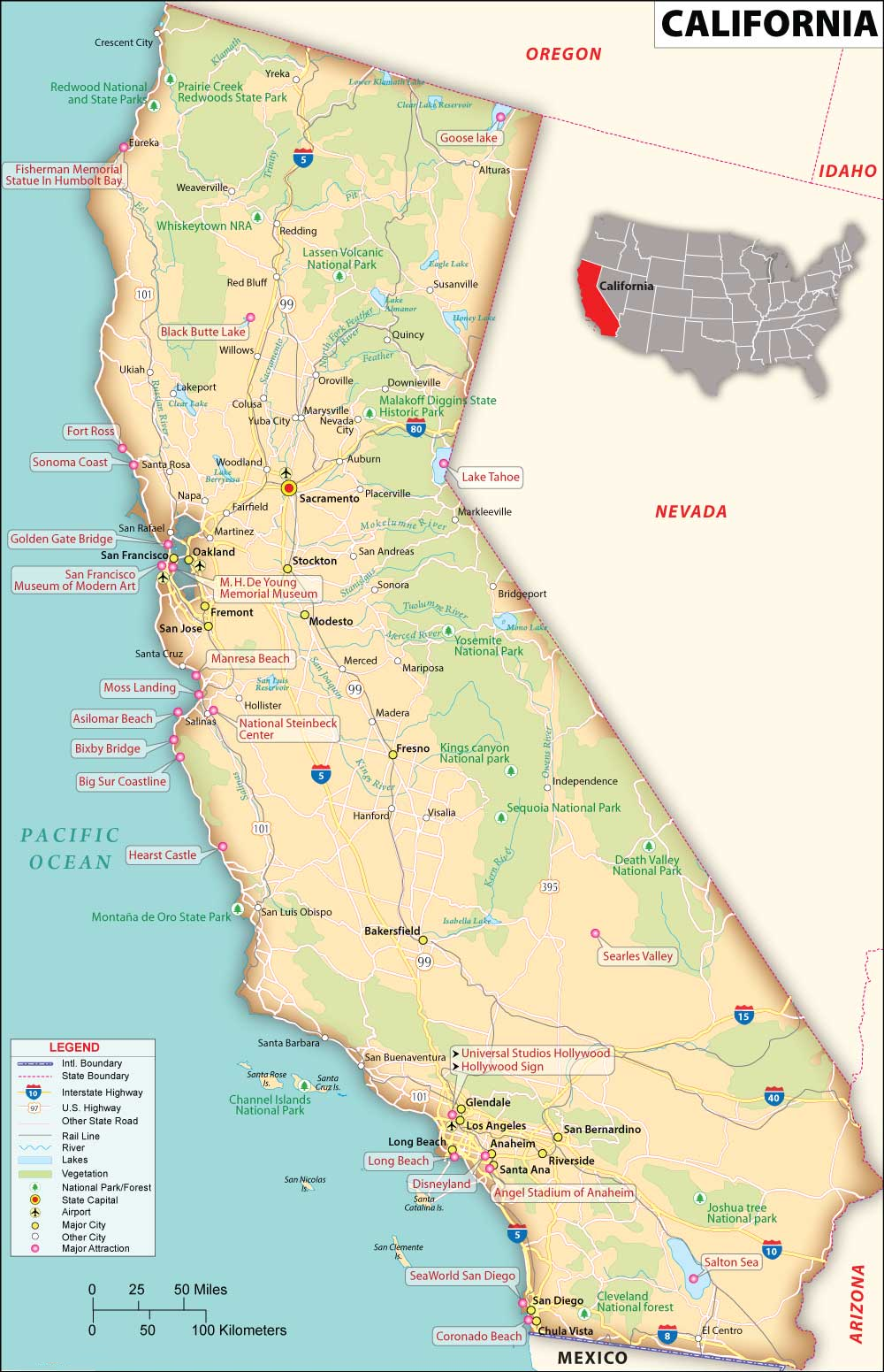
1. California County Map with Cities:

2. County Map of California:

3. California County Map (Type -3):

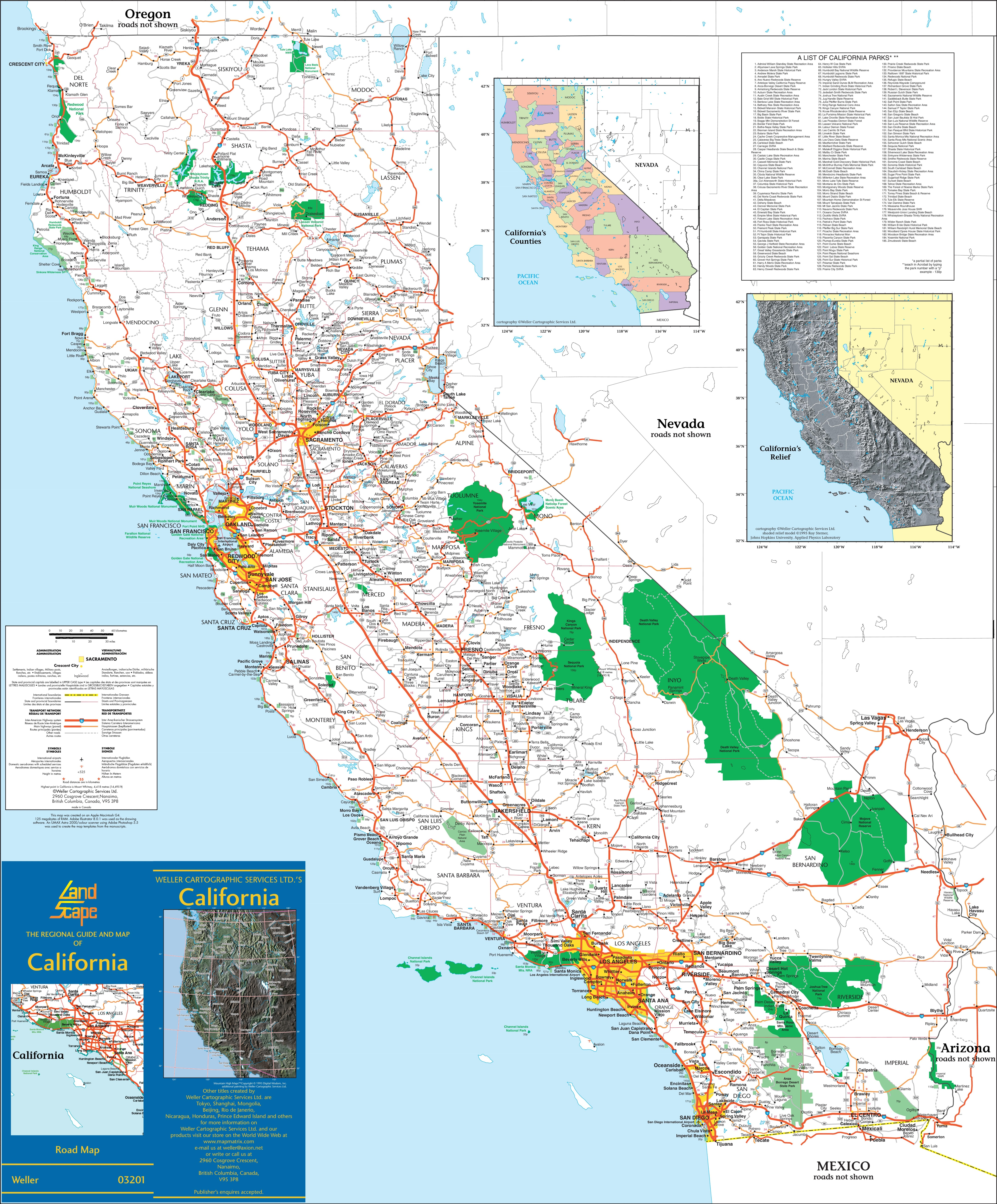
4. Map of California :
5. California Map with Cities & Towns:
Above we have added the collection of printable maps of California County. We have added five maps that contain useful information about all counties of this state. Below, we are adding some brief information about each map. So, please read the full description before viewing or saving any map on any of your devices. We are also including a table that shows some useful information about counties. Please check the entire table.
This is a list of all counties with some additional information like name of county name, year of establishment, populations, and total area.
| County | Established | Population | Area |
| Alpine County | 1864 | 1235 | 739 sq mi |
| Amador County | 1854 | 41259 | 606 sq mi |
| Butte County | 1850 | 208309 | 1,640 sq mi |
| Calaveras County | 1850 | 46221 | 1,020 sq mi |
| Colusa County | 1850 | 21917 | 1,151 sq mi |
| Contra Costa County | 1850 | 1161413 | 720 sq mi |
| Del Norte County | 1857 | 28100 | 1,008 sq mi |
| El Dorado County | 1850 | 193221 | 1,712 sq mi |
| Fresno County | 1856 | 1013581 | 5,963 sq mi |
| Glenn County | 1891 | 28805 | 1,315 sq mi |
| Humboldt County | 1853 | 136310 | 3,573 sq mi |
| Imperial County | 1907 | 179851 | 4,175 sq mi |
| Inyo County | 1866 | 18970 | 10,192 sq mi |
| Kern County | 1866 | 917673 | 8,142 sq mi |
| Kings County | 1893 | 153443 | 1,390 sq mi |
| Lake County | 1861 | 68766 | 1,258 sq mi |
| Lassen County | 1864 | 33159 | 4,558 sq mi |
| Los Angeles County | 1850 | 9829544 | 4,060 sq mi |
| Madera County | 1893 | 159410 | 2,138 sq mi |
| Marin County | 1850 | 260206 | 520 sq mi |
| Mariposa County | 1850 | 17147 | 1,451 sq mi |
| Mendocino County | 1850 | 91305 | 3,509 sq mi |
| Merced County | 1855 | 286461 | 1,929 sq mi |
| Modoc County | 1874 | 8661 | 3,944 sq mi |
| Mono County | 1861 | 13247 | 3,044 sq mi |
| Monterey County | 1850 | 437325 | 3,322 sq mi |
| Napa County | 1850 | 136207 | 754 sq mi |
| Nevada County | 1851 | 103487 | 958 sq mi |
| Orange County | 1889 | 3167809 | 948 sq mi |
| Placer County | 1851 | 412300 | 1,407 sq mi |
| Plumas County | 1854 | 19915 | 2,554 sq mi |
| Riverside County | 1893 | 2458395 | 7,208 sq mi |
| Sacramento County | 1850 | 1588921 | 966 sq mi |
| San Benito County | 1874 | 66677 | 1,389 sq mi |
| San Bernardino County | 1853 | 2194710 | 20,062 sq mi |
| San Diego County | 1850 | 3286069 | 4,204 sq mi |
| San Francisco | 1850 | 815201 | 47 sq mi |
| San Joaquin County | 1850 | 789410 | 1,399 sq mi |
| San Luis Obispo County | 1850 | 283159 | 3,304 sq mi |
| San Mateo County | 1856 | 737888 | 449 sq mi |
| Santa Barbara County | 1850 | 446475 | 2,738 sq mi |
| Santa Clara County | 1850 | 1885508 | 1,291 sq mi |
| Santa Cruz County | 1850 | 267792 | 446 sq mi |
| Shasta County | 1850 | 182139 | 3,786 sq mi |
| Sierra County | 1852 | 3283 | 953 sq mi |
| Siskiyou County | 1852 | 44118 | 6,287 sq mi |
| Solano County | 1850 | 451716 | 828 sq mi |
| Sonoma County | 1850 | 485887 | 1,576 sq mi |
| Stanislaus County | 1854 | 552999 | 1,495 sq mi |
| Sutter County | 1850 | 99063 | 603 sq mi |
| Tehama County | 1856 | 65498 | 2,951 sq mi |
| Trinity County | 1850 | 16060 | 3,179 sq mi |
| Tulare County | 1852 | 477054 | 4,824 sq mi |
| Tuolumne County | 1850 | 55810 | 2,236 sq mi |
| Ventura County | 1872 | 839784 | 1,846 sq mi |
| Yolo County | 1850 | 216986 | 1,012 sq mi |
| Yuba County | 1850 | 83421 | 630 sq mi |
The first map is the main county map of California State with some major cities. The second map is a simple county map related to all counties of California. And the next map is a CA county map that shows its county seat (administrator city) in California. This map is the same as the other two maps but visually different. Check the first map if you are looking for a detailed county map of California, USA
You can check the further links if you are looking for some other maps related to California, USA.
- California Road Maps
- California River Maps
- California Mountains Ranges Maps
- California Highway Maps
- Printable Maps of California
And the fourth map is a state map of California. This map is the main and detailed printable map of this state. The fifth map is a map of California with cities that shows all cities, roads, highways, rivers, and lakes. So, these were some high-quality and printable maps that we have added above. These large HD maps are available in PDF and JPG (Image) formats. You can easily download any map by clicking on the buttons under the preview image. All these maps are free to download.