Chicago is the state’s largest and country’s third most populous city in the United States of America. This city has two international commercial airports, which are known as O’Hare International Airport and Midway Airport. According to a survey, Chicago O’Hare International Airport is currently the sixth busiest airport in the world. If you want to travel in this or you have any flight from this city, then you must have knowledge about the airport, its entrance, terminals and other important places.
Here on this page, we are adding the Chicago midway airport map, terminals map and airport direction map. Please, scroll down the page and have a look at these maps.
All Maps of Chicago Airport (O’Hare International Airport):
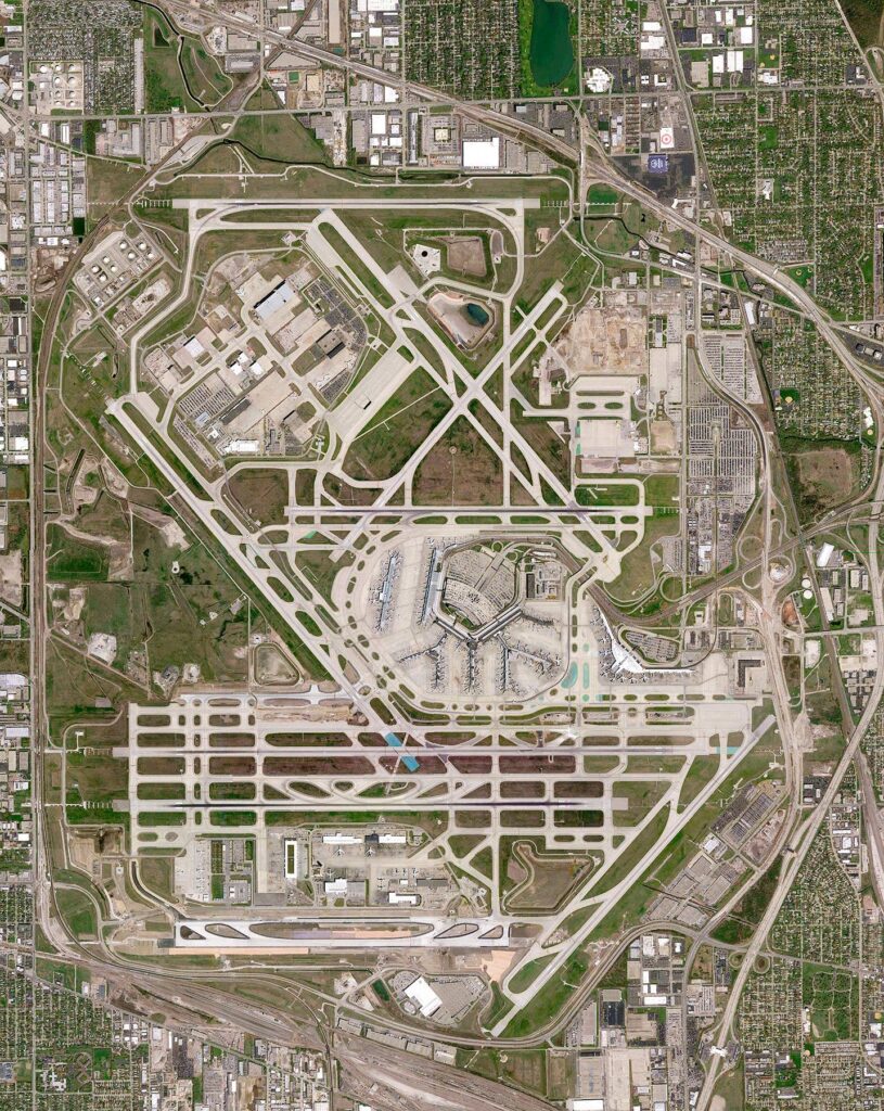
1. Chicago Airport Map:
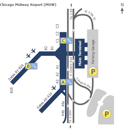
2. Chicago Midway Airport Map:
3. Chicago ORD Airport Map:
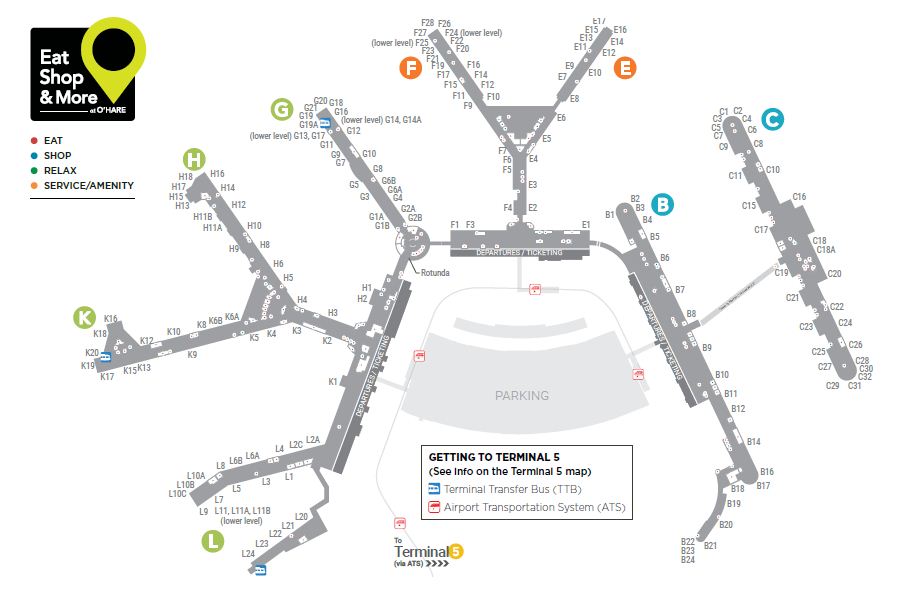
4. Full Terminal Map of Chicago International Airport:
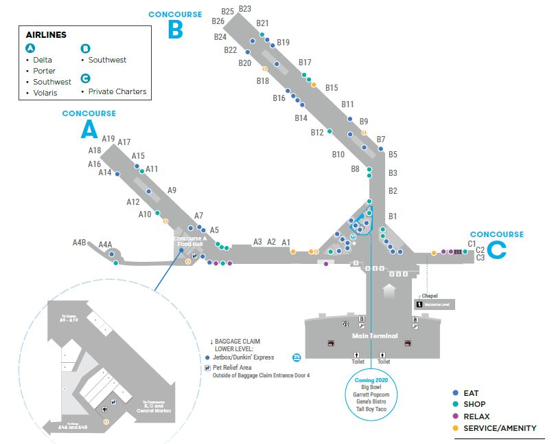
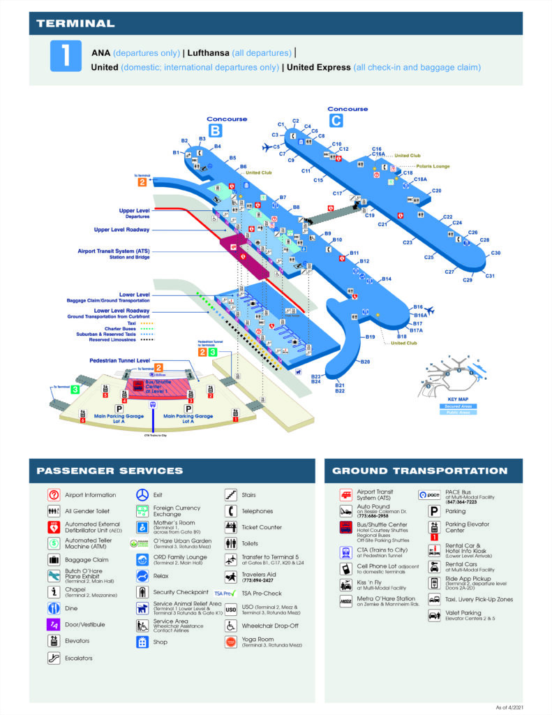
5. Terminal-1 Map of Chicago International Airport:
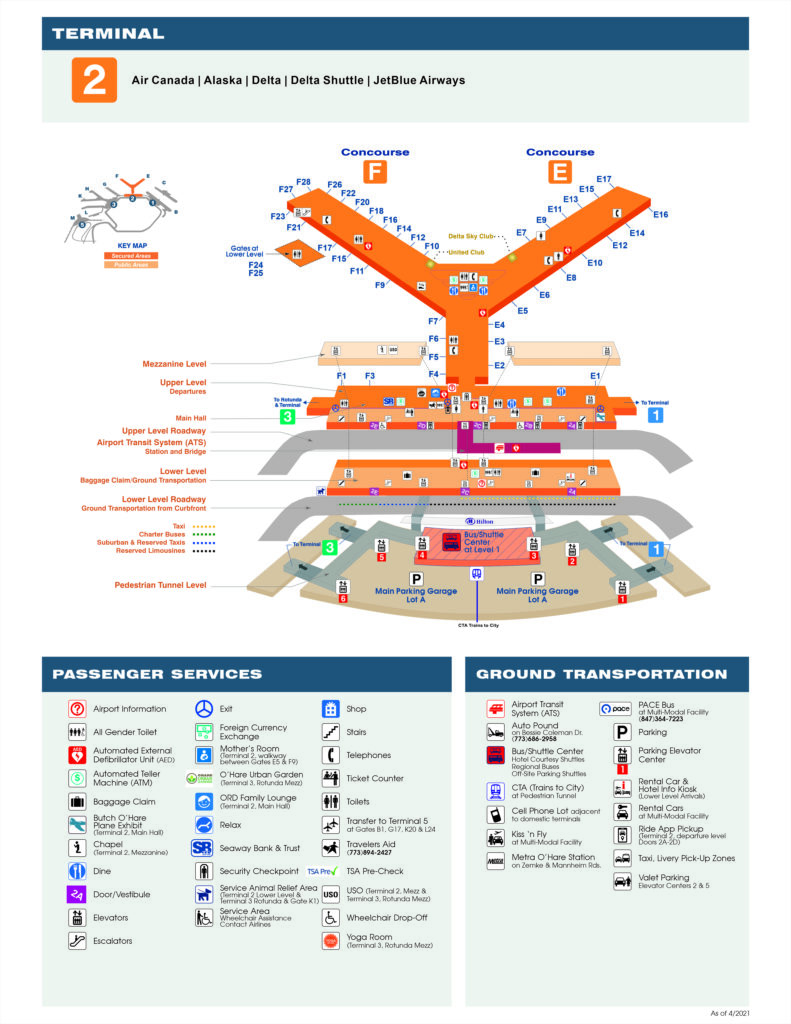
6. Terminal-2 Map of Chicago International Airport:
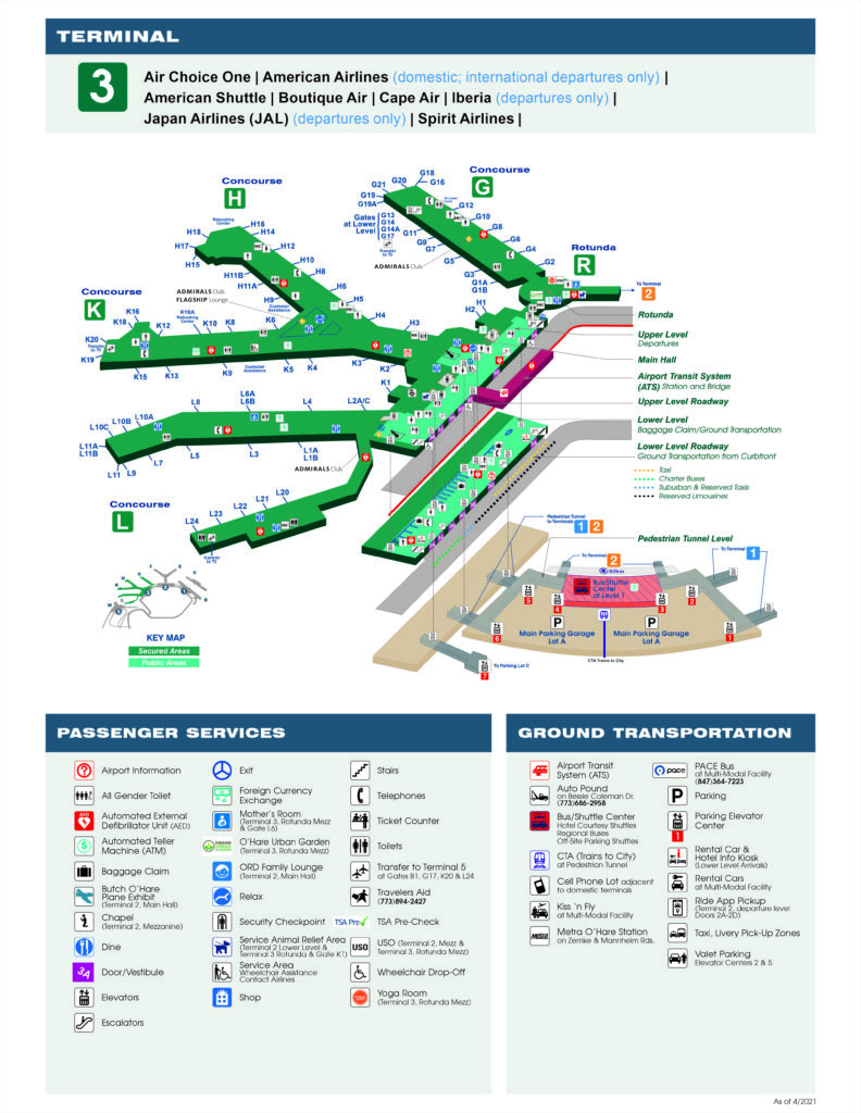
7. Terminal-3 Map of Chicago International Airport:
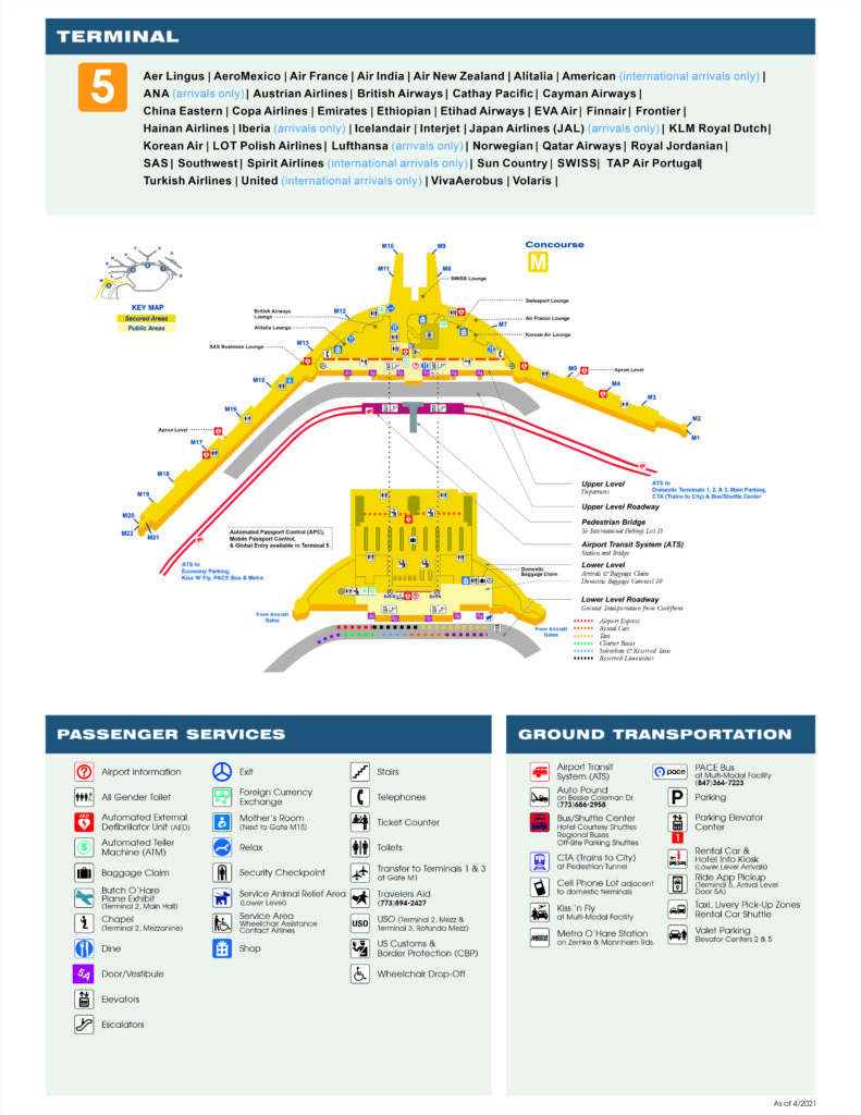
8. Terminal-5 Map of Chicago International Airport:
9. Chicago Midway Gate Map:
Chicago Airport Address:
Chicago Airport is the sixth busiest airport in the world in terms of passenger traffic. It is located in Chicago, Illinois, USA. Also known as O’Hare International Airport. Below, we are mentioning the official address of this airport.
Address of Chicago International Airport:
10000 W O'Hare Ave
Chicago
IL 60666
USA
Directions to Chicago Airport:
Here, you will get to know directions and route to the Chigao International Airport from other major locations and cities.
Directions to Chicago O’Hare International Airport (ORD) from the City Center
Please use the I-90 interstate and head in a west direction. After that, follow the airport signposts, take the I-190 west and then head towards the terminals.
Directions to Chicago O’Hare International Airport (ORD) from the Northbrook
You have to use I-294 (Tri-State Tollway), head in a southerly direction, follow the airport signposts, take the I-190 west, and turn into the grounds.
Directions to Chicago O’Hare International Airport (ORD) from the South (Elmhurst)
Take the I-294 interstate and head in a northerly direction, then follow the signs, now use the I-190 west and then turn into the airport
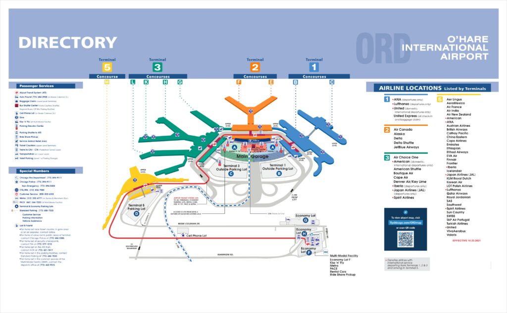
Above, we have added nine types of O’Hare International Airport Map. All maps contain the useful information that you need. With the help of these maps, you can navigate the airport, its terminals, entrance gates, parking area, lounges, restrooms, shops, food stalls, etc. Below, we are also describing each map. Please read the description before viewing or downloading any map.
The first map is the main Chicago Airport Map, which shows the whole area of the airport. It is a google map showing the aerial view of this airport. The second map is Chicago Midway Airport Map. In this map, you will get to know about the layout of this airport. Midway airport is also a commercial airport, but it is smaller than the ORD. This airport is very close to Downtown Chicago.
The third map is titled “Chicago ORD Airport Map.” This map shows all terminals and their concourses. Shops and other services points are also visible on this map. The fourth map is a detailed map and specific terminal map which shows all terminals – T1, T2, T3, and T5. Please check this map for detailed information.
The fifth map is related to Terminal-1. This map shows the full details about the T-1. In this map, you will also know about some airlines that have their arrival and departure from this terminal. The sixth map is about Terminal-2 and contains the same information as the previous map. The next map is a map that is related to the terminal map of T-3. This map also shows the same detailed information as the previous terminals map. Please check the specific map for the information.
The eighth map is a specific map of Terminal – 5. This map also shows the layout of T-5, its concourses, secured areas, public areas, entry-exit points, parking areas, etc. The last map shows the Gates of the Midway Airport. As you can see on the map, this airport has two gates that are: B1 and A5. Please check the map for more details.
The above Chicago’s airport and their terminal maps are available in both PDF and JPG (Image) format. You can download any map according to your need. These maps can be printed because these maps are available in HD quality. And, if you are also looking for some Chicago (Illinois) Metro Map and Road & Highway Maps of Chicago (Illinois), then please click on the links and have a look at these other maps of Chicago.