Virginia, a state situated in the Mid-Atlantic and Southeastern region of the United States is divided into 95 counties and 38 independent cities which are considered Counties. Here, we are adding some printable maps related to counties of Virginia, USA. You can explore Virginia state with the help of a county map of Virginia state. Below, we are also adding a list of all counties with some useful information. So, please scroll down the page and check our collection of maps related to counties and cities of Virginia.
Virginia (VA) County Maps Collection:
1. County Map of Virginia:

2. VA County Map:

3. State Map of Virginia:

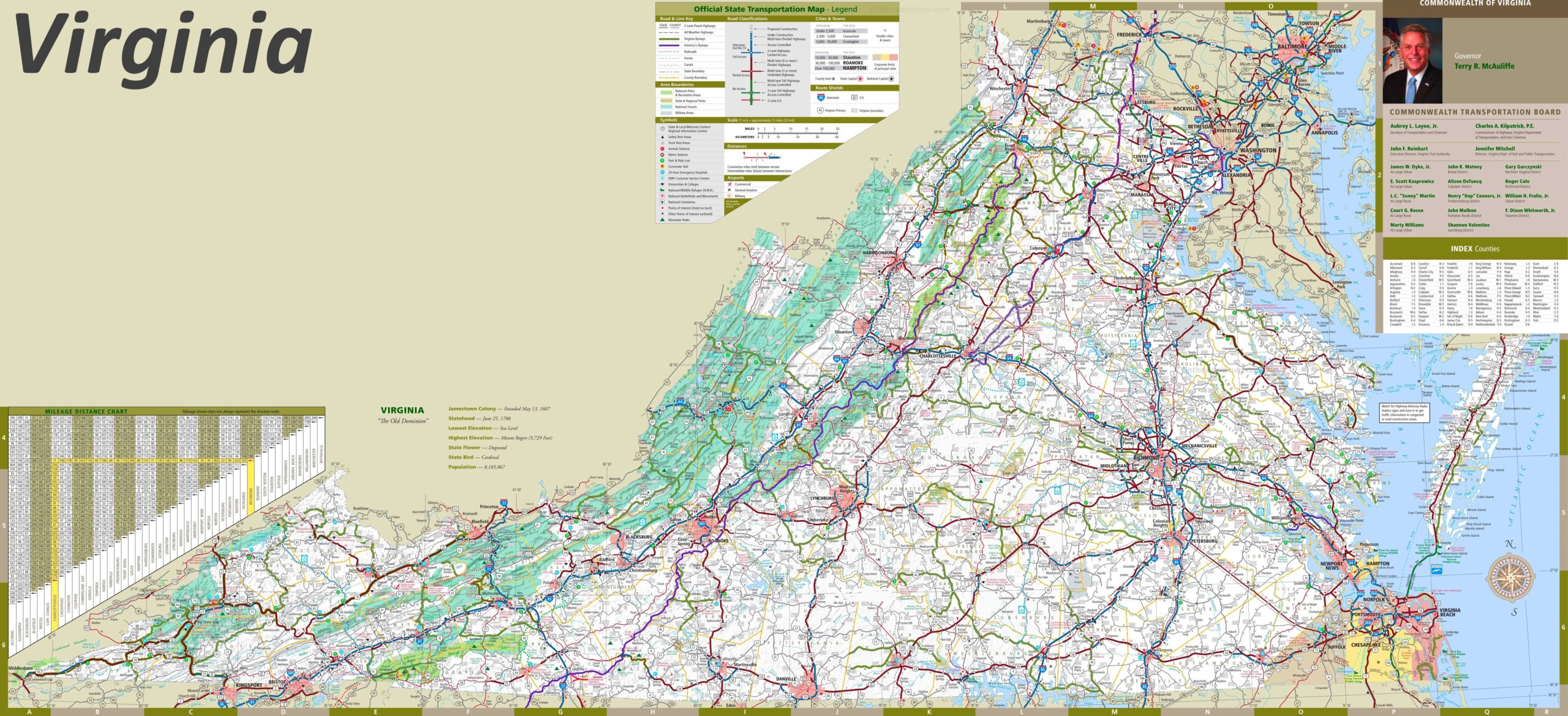
4. Cities & Towns Map of Virginia:
Here, we have added 04 county maps. Each map contains some useful information. For you, we are also adding some more useful information about each county. So, read the description and save any map for any work or purpose. We are also adding a table that shows some information about the counties of this state.
List of all Counties in the Virginia State:
With the help of this table, you will get some quick information about the counties. And for some additional information, you can check the first map which is a county map of Virginia.
| S.N | County | County Seat | Population | Area | Formed |
| 1 | Accomack County | Accomac | 33164 | 455 sq mi | 1663 |
| 2 | Albemarle County | Charlottesville | 98970 | 723 sq mi | 1744 |
| 3 | Alleghany County | Covington | 16250 | 446 sq mi | 1822 |
| 4 | Amelia County | Amelia Court House | 11400 | 357 sq mi | 1735 |
| 5 | Amherst County | Amherst | 31894 | 475 sq mi | 1761 |
| 6 | Appomattox County | Appomattox | 13705 | 334 sq mi | 1845 |
| 7 | Arlington County | Arlington | 220565 | 26 sq mi | 1846 |
| 8 | Augusta County | Staunton | 73750 | 971 sq mi | 1738 |
| 9 | Bath County | Warm Springs | 5048 | 532 sq mi | 1791 |
| 10 | Bedford County | Bedford | 60371 | 755 sq mi | 1754 |
| 11 | Bland County | Bland | 6871 | 359 sq mi | 1861 |
| 12 | Botetourt County | Fincastle | 30496 | 543 sq mi | 1770 |
| 13 | Brunswick County | Lawrenceville | 18419 | 566 sq mi | 1720 |
| 14 | Buchanan County | Grundy | 26978 | 504 sq mi | 1858 |
| 15 | Buckingham County | Buckingham | 15623 | 581 sq mi | 1761 |
| 16 | Campbell County | Rustburg | 51078 | 504 sq mi | 1782 |
| 17 | Caroline County | Bowling Green | 28545 | 533 sq mi | 1728 |
| 18 | Carroll County | Hillsville | 30042 | 476 sq mi | 1842 |
| 19 | Charles City County | Charles City | 6926 | 182 sq mi | 1634 |
| 20 | Charlotte County | Charlotte Court House | 12472 | 475 sq mi | 1765 |
| 21 | Chesterfield County | Chesterfield | 322388 | 426 sq mi | 1749 |
| 22 | Clarke County | Berryville | 12652 | 177 sq mi | 1836 |
| 23 | Craig County | New Castle | 5091 | 330 sq mi | 1851 |
| 24 | Culpeper County | Culpeper | 46689 | 381 sq mi | 1749 |
| 25 | Cumberland County | Cumberland | 9017 | 298 sq mi | 1749 |
| 26 | Dickenson County | Clintwood | 16395 | 333 sq mi | 1880 |
| 27 | Dinwiddie County | Dinwiddie | 24533 | 504 sq mi | 1752 |
| 28 | Essex County | Tappahannock | 9989 | 258 sq mi | 1692 |
| 29 | Fairfax County | Fairfax | 1118602 | 396 sq mi | 1742 |
| 30 | Fauquier County | Warrenton | 68010 | 650 sq mi | 1759 |
| 31 | Floyd County | Floyd | 13874 | 382 sq mi | 1831 |
| 32 | Fluvanna County | Palmyra | 20047 | 287 sq mi | 1777 |
| 33 | Franklin County | Rocky Mount | 47286 | 692 sq mi | 1786 |
| 34 | Frederick County | Winchester | 59209 | 415 sq mi | 1738 |
| 35 | Giles County | Pearisburg | 16657 | 358 sq mi | 1806 |
| 36 | Gloucester County | Gloucester | 34780 | 217 sq mi | 1651 |
| 37 | Goochland County | Goochland | 16863 | 284 sq mi | 1728 |
| 38 | Grayson County | Independence | 17917 | 443 sq mi | 1793 |
| 39 | Greene County | Stanardsville | 15244 | 157 sq mi | 1838 |
| 40 | Greensville County | Emporia | 11560 | 296 sq mi | 1781 |
| 41 | Halifax County | Halifax | 37355 | 814 sq mi | 1752 |
| 42 | Hanover County | Hanover | 101327 | 473 sq mi | 1721 |
| 43 | Henrico County | Richmond | 306935 | 238 sq mi | 1617 |
| 44 | Henry County | Martinsville | 57930 | 382 sq mi | 1777 |
| 45 | Highland County | Monterey | 2536 | 416 sq mi | 1847 |
| 46 | Isle of Wight County | Isle of Wight | 29728 | 316 sq mi | 1634 |
| 47 | James City County | Williamsburg | 68971 | 143 sq mi | 1617 |
| 48 | King and Queen County | King and Queen Court House | 6630 | 316 sq mi | 1691 |
| 49 | King George County | King George | 16803 | 180 sq mi | 1721 |
| 50 | King William County | King William | 13146 | 275 sq mi | 1702 |
| 51 | Lancaster County | Lancaster | 11567 | 133 sq mi | 1651 |
| 52 | Lee County | Jonesville | 23589 | 437 sq mi | 1793 |
| 53 | Loudoun County | Leesburg | 333253 | 520 sq mi | 1757 |
| 54 | Louisa County | Louisa | 25627 | 498 sq mi | 1742 |
| 55 | Lunenburg County | Lunenburg | 13146 | 432 sq mi | 1746 |
| 56 | Madison County | Madison | 12520 | 322 sq mi | 1793 |
| 57 | Mathews County | Mathews | 9207 | 86 sq mi | 1791 |
| 58 | Mecklenburg County | Boydton | 32380 | 624 sq mi | 1765 |
| 59 | Middlesex County | Saluda | 9932 | 130 sq mi | 1673 |
| 60 | Montgomery County | Christiansburg | 83629 | 388 sq mi | 1777 |
| 61 | Nelson County | Lovingston | 14445 | 472 sq mi | 1808 |
| 62 | New Kent County | New Kent | 13462 | 210 sq mi | 1654 |
| 63 | Northampton County | Eastville | 13093 | 207 sq mi | 1634 |
| 64 | Northumberland County | Heathsville | 12259 | 192 sq mi | 1648 |
| 65 | Nottoway County | Nottoway | 15725 | 315 sq mi | 1789 |
| 66 | Orange County | Orange | 25881 | 342 sq mi | 1734 |
| 67 | Page County | Luray | 23177 | 311 sq mi | 1831 |
| 68 | Patrick County | Stuart | 19407 | 483 sq mi | 1791 |
| 69 | Pittsylvania County | Chatham | 61745 | 978 sq mi | 1767 |
| 70 | Powhatan County | Powhatan | 22377 | 261 sq mi | 1777 |
| 71 | Prince Edward County | Farmville | 19720 | 353 sq mi | 1754 |
| 72 | Prince George County | Prince George | 33047 | 266 sq mi | 1703 |
| 73 | Prince William County | Manassas | 421164 | 338 sq mi | 1731 |
| 74 | Pulaski County | Pulaski | 35127 | 321 sq mi | 1839 |
| 75 | Rappahannock County | Washington | 6983 | 267 sq mi | 1833 |
| 76 | Richmond County | Warsaw | 8809 | 192 sq mi | 1692 |
| 77 | Roanoke County | Salem | 85778 | 251 sq mi | 1838 |
| 78 | Rockbridge County | Lexington | 20808 | 600 sq mi | 1778 |
| 79 | Rockingham County | Harrisonburg | 67725 | 851 sq mi | 1778 |
| 80 | Russell County | Lebanon | 30308 | 475 sq mi | 1786 |
| 81 | Scott County | Gate City | 23403 | 537 sq mi | 1814 |
| 82 | Shenandoah County | Woodstock | 35075 | 512 sq mi | 1772 |
| 83 | Smyth County | Marion | 33081 | 452 sq mi | 1832 |
| 84 | Southampton County | Courtland | 17482 | 600 sq mi | 1749 |
| 85 | Spotsylvania County | Spotsylvania Courthouse | 125684 | 401 sq mi | 1721 |
| 86 | Stafford County | Stafford | 132791 | 270 sq mi | 1664 |
| 87 | Surry County | Surry | 6829 | 279 sq mi | 1652 |
| 88 | Sussex County | Sussex | 12504 | 491 sq mi | 1754 |
| 89 | Tazewell County | Tazewell | 44598 | 520 sq mi | 1800 |
| 90 | Warren County | Front Royal | 31584 | 214 sq mi | 1836 |
| 91 | Washington County | Abingdon | 51103 | 564 sq mi | 1777 |
| 92 | Westmoreland County | Montross | 16718 | 229 sq mi | 1653 |
| 93 | Wise County | Wise | 40123 | 403 sq mi | 1856 |
| 94 | Wythe County | Wytheville | 27599 | 463 sq mi | 1790 |
| 95 | York County | Yorktown | 65464 | 106 sq mi | 1634 |
List of all Independent Cities in the Virginia, USA:
This is a list which is showing all independent cities of Virginia which are considered the county.
| S.N | City | Area | Formed |
| 1 | City of Alexandria | 15 sq mi | 1902 |
| 2 | City of Bristol | 12 sq mi | 1902 |
| 3 | City of Buena Vista | 7 sq mi | 1902 |
| 4 | City of Charlottesville | 10 sq mi | 1902 |
| 5 | City of Chesapeake | 341 sq mi | 1963 |
| 6 | City of Colonial Heights | 8 sq mi | 1948 |
| 7 | City of Covington | 4 sq mi | 1952 |
| 8 | City of Danville | 43 sq mi | 1902 |
| 9 | City of Emporia | 7 sq mi | 1967 |
| 10 | City of Fairfax | 6 sq mi | 1961 |
| 11 | City of Falls Church | 2 sq mi | 1948 |
| 12 | City of Franklin | 8 sq mi | 1961 |
| 13 | City of Fredericksburg | 10 sq mi | 1902 |
| 14 | City of Galax | 8 sq mi | 1952 |
| 15 | City of Hampton | 52 sq mi | 1908 |
| 16 | City of Harrisonburg | 18 sq mi | 1916 |
| 17 | City of Hopewell | 10 sq mi | 1916 |
| 18 | City of Lexington | 2 sq mi | 1966 |
| 19 | City of Lynchburg | 49 sq mi | 1902 |
| 20 | City of Manassas | 10 sq mi | 1975 |
| 21 | City of Manassas Park | 2 sq mi | 1975 |
| 22 | City of Martinsville | 11 sq mi | 1928 |
| 23 | City of Newport News | 68 sq mi | 1902 |
| 24 | City of Norfolk | 54 sq mi | 1845 |
| 25 | City of Norton | 7 sq mi | 1954 |
| 26 | City of Petersburg | 23 sq mi | 1902 |
| 27 | City of Poquoson | 16 sq mi | 1975 |
| 28 | City of Portsmouth | 33 sq mi | 1858 |
| 29 | City of Radford | 10 sq mi | 1902 |
| 30 | City of Richmond | 60 sq mi | 1902 |
| 31 | City of Roanoke | 43 sq mi | 1902 |
| 32 | City of Salem | 15 sq mi | 1968 |
| 33 | City of Staunton | 20 sq mi | 1902 |
| 34 | City of Suffolk | 400 sq mi | 1910 |
| 35 | City of Virginia Beach | 248 sq mi | 1963 |
| 36 | City of Waynesboro | 14 sq mi | 1948 |
| 37 | City of Williamsburg | 9 sq mi | 1902 |
| 38 | City of Winchester | 9 sq mi | 1902 |
In the first map, you will see the name of all counties and their location on the Virginia Map. It is the main county map of Virginia state. Now, the second map is a detailed VA county map. This map shows counties along with all major cities and towns. So, you can get this map if you have any work related to the Counties of this state.
The fifth map is a simple state map of Virginia. This map only shows all counties, towns, cities, mountains, rivers, and lakes. The sixth map is a detailed and large map of Virginia’s Cities and Towns. It is a complete and printable map showing all cities, roads, interstate highways, and their routes. With the help of this map, you can easily move anywhere in any city in Virginia. So, these were some printable maps related to Virginia county and towns that we have added above. These high-quality maps are available in PDF and JPG formats. You can easily download any map by clicking on the buttons under the preview image. All these maps are free to download.