Oklahoma state has 77 counties that are controlled and managed by its county administration. Each county has its specific county seat. So, if you are here to learn something about the counties of Oklahoma, you should scroll down the page and grab all the information we have provided below. And in addition, we have also added a map of Oklahoma with counties. Please scroll down the page and check our collections of maps.
Oklahoma (OK) County Maps Collection:
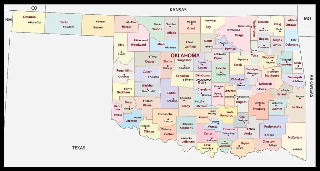
1. Oklahoma County Map:
2. Oklahoma County Map with Cities:

3. Map of Oklahoma with Counties:

4. Oklahoma Map with Cities:
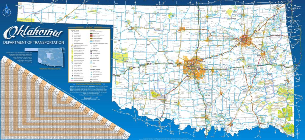
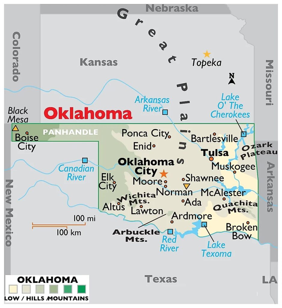
5. Oklahoma Map:
We have added above this collection of printable maps of Oklahoma County. We have added different maps that contain helpful information about the counties. Below, we are adding some brief information about each map. So, please read the full description before viewing or saving any map in your device. We are also adding a list that shows some useful information about the counties of this state. Please read the entire table.
List of all Counties in Oklahoma State
This is a list of all counties of Oklahoma with some additional information like name of county name, year of established in, populations, the county seat, and total area.
| County | Established In | Population | Area | County seat |
| Adair County | 1907 | 19495 | 576 sq mi | Stilwell |
| Alfalfa County | 1907 | 5699 | 867 sq mi | Cherokee |
| Atoka County | 1907 | 14143 | 978 sq mi | Atoka |
| Beaver County | 1890 | 5049 | 1,814 sq mi | Beaver |
| Beckham County | 1907 | 22410 | 902 sq mi | Sayre |
| Blaine County | 1890 | 8735 | 929 sq mi | Watonga |
| Bryan County | 1907 | 46067 | 909 sq mi | Durant |
| Caddo County | 1901 | 26945 | 1,278 sq mi | Anadarko |
| Canadian County | 1901 | 154405 | 900 sq mi | El Reno |
| Carter County | 1907 | 48003 | 824 sq mi | Ardmore |
| Cherokee County | 1907 | 47078 | 751 sq mi | Tahlequah |
| Choctaw County | 1907 | 14204 | 774 sq mi | Hugo |
| Cimarron County | 1907 | 2296 | 1,835 sq mi | Boise City |
| Cleveland County | 1890 | 295528 | 536 sq mi | Norman |
| Coal County | 1907 | 5266 | 518 sq mi | Coalgate |
| Comanche County | 1907 | 121125 | 1,069 sq mi | Lawton |
| Cotton County | 1912 | 5527 | 637 sq mi | Walters |
| Craig County | 1907 | 14107 | 761 sq mi | Vinita |
| Creek County | 1907 | 71754 | 956 sq mi | Sapulpa |
| Custer County | 1891 | 28513 | 987 sq mi | Arapaho |
| Delaware County | 1907 | 40397 | 741 sq mi | Jay |
| Dewey County | 1892 | 4484 | 1,000 sq mi | Taloga |
| Ellis County | 1907 | 3749 | 1,229 sq mi | Arnett |
| Garfield County | 1893 | 62846 | 1,058 sq mi | Enid |
| Garvin County | 1907 | 25656 | 809 sq mi | Pauls Valley |
| Grady County | 1907 | 54795 | 1,101 sq mi | Chickasha |
| Grant County | 1892 | 4169 | 1,001 sq mi | Medford |
| Greer County | 1896 | 5491 | 639 sq mi | Mangum |
| Harmon County | 1909 | 2488 | 538 sq mi | Hollis |
| Harper County | 1893 | 3272 | 1,039 sq mi | Buffalo |
| Haskell County | 1907 | 11561 | 577 sq mi | Stigler |
| Hughes County | 1907 | 13367 | 807 sq mi | Holdenville |
| Jackson County | 1907 | 24785 | 803 sq mi | Altus |
| Jefferson County | 1907 | 5337 | 759 sq mi | Waurika |
| Johnston County | 1907 | 10272 | 645 sq mi | Tishomingo |
| Kay County | 1895 | 43700 | 919 sq mi | Newkirk |
| Kingfisher County | 1907 | 15184 | 903 sq mi | Kingfisher |
| Kiowa County | 1901 | 8509 | 1,015 sq mi | Hobart |
| Latimer County | 1907 | 9444 | 722 sq mi | Wilburton |
| Le Flore County | 1907 | 48129 | 1,586 sq mi | Poteau |
| Lincoln County | 1891 | 33458 | 959 sq mi | Chandler |
| Logan County | 1891 | 49555 | 745 sq mi | Guthrie |
| Love County | 1907 | 10146 | 515 sq mi | Marietta |
| Major County | 1907 | 7782 | 957 sq mi | Fairview |
| Marshall County | 1907 | 15312 | 371 sq mi | Madill |
| Mayes County | 1907 | 39046 | 656 sq mi | Pryor |
| McClain County | 1907 | 41662 | 570 sq mi | Purcell |
| McCurtain County | 1907 | 30814 | 1,852 sq mi | Idabel |
| McIntosh County | 1907 | 18941 | 620 sq mi | Eufaula |
| Murray County | 1907 | 13904 | 418 sq mi | Sulphur |
| Muskogee County | 1907 | 66339 | 814 sq mi | Muskogee |
| Noble County | 1897 | 10924 | 732 sq mi | Perry |
| Nowata County | 1907 | 9320 | 565 sq mi | Nowata |
| Okfuskee County | 1907 | 11310 | 625 sq mi | Okemah |
| Oklahoma County | 1891 | 796292 | 709 sq mi | Oklahoma City |
| Okmulgee County | 1907 | 36706 | 697 sq mi | Okmulgee |
| Osage County | 1907 | 45818 | 2,251 sq mi | Pawhuska |
| Ottawa County | 1907 | 30285 | 471 sq mi | Miami |
| Pawnee County | 1897 | 15553 | 570 sq mi | Pawnee |
| Payne County | 1890 | 81646 | 686 sq mi | Stillwater |
| Pittsburg County | 1907 | 43773 | 1,306 sq mi | McAlester |
| Pontotoc County | 1907 | 38065 | 720 sq mi | Ada |
| Pottawatomie County | 1891 | 72454 | 788 sq mi | Shawnee |
| Pushmataha County | 1907 | 10812 | 1,397 sq mi | Antlers |
| Roger Mills County | 1895 | 3442 | 1,142 sq mi | Cheyenne |
| Rogers County | 1907 | 95240 | 675 sq mi | Claremore |
| Seminole County | 1907 | 23556 | 632 sq mi | Wewoka |
| Sequoyah County | 1907 | 39281 | 674 sq mi | Sallisaw |
| Stephens County | 1907 | 42848 | 877 sq mi | Duncan |
| Texas County | 1907 | 21384 | 2,037 sq mi | Guymon |
| Tillman County | 1907 | 6968 | 872 sq mi | Frederick |
| Tulsa County | 1907 | 669279 | 570 sq mi | Tulsa |
| Wagoner County | 1907 | 80981 | 563 sq mi | Wagoner |
| Washington County | 1907 | 52455 | 417 sq mi | Bartlesville |
| Washita County | 1897 | 10924 | 1,004 sq mi | Cordell |
| Woods County | 1893 | 8624 | 1,287 sq mi | Alva |
| Woodward County | 1893 | 20470 | 1,242 sq mi | Woodward |
The first map is a coloured county map of Oklahoma, which shows only county names. And the next map is a detailed OK county map with cities and towns. So, check this map if you are looking for a detailed county map of this state. The third map is also a county map, but it is visually different from the above two maps. This map shows all county seats of Oklahoma state. The fourth map is a state map of Oklahoma with cities that shows all counties, cities, roads, highways, rivers and lakes. And the last map is a map of Oklahoma state. And, if you are looking for some state maps, and cities maps of Oklahoma then you should click this link.
So, these were some high-quality and printable maps that we have added above. These large HD maps are available in PDF and JPG (Image) formats. You can easily download any map by clicking on the buttons under the preview image. All these maps are free to download.