County maps are very useful if someone is gathering information about the counties and cities of any state. With the help of these maps, you can easily locate any county and gather brief information. So, if you are looking for a map of Oregon with counties, you are on the right page. Here on this page, we are adding some Oregon state county maps and Oregon state maps. Please scroll down the page and have a look at these best printable maps.
Oregon (OR) County Maps Collection:
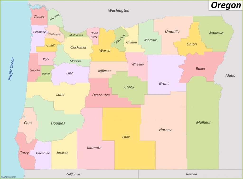
1. Map of Oregon with Counties:
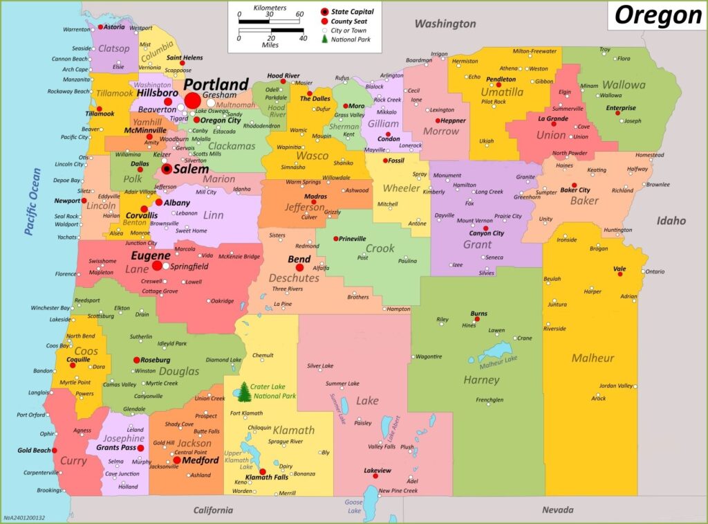
2. Oregon County Map with Cities:
3. Oregon County Map:

4. Oregon Map with Cities and Towns:
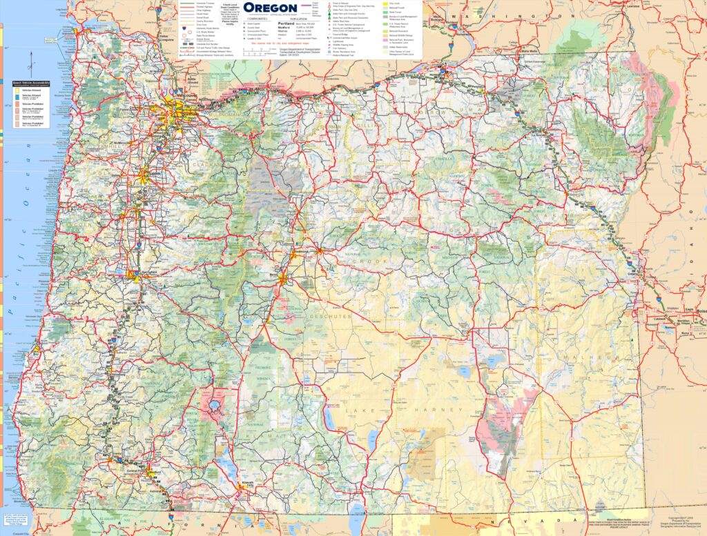
5. Map of the State Oregon:

This is the collection of some high-quality map of OR counties that we have added above. We have added a total of five different maps that contain some helpful information about the counties and cities of Oregon state. Here, we are adding some brief information about each map. So, please read the full description before downloading any map from the above collection.
The first map is a simple outline county map of Oregon, which shows only county names. And the next map is a detailed county map with cities. So, you can check the second map if you need a detailed county map of this state. The third map is also a county map of OR state, but it is visually different. Below we are also adding a table that shows some useful information about the counties of Oregon. Please read the entire table for additional information.
Counties in Oregon, USA:
This is a list of all counties of Oregon with some useful information like name of county, the county seat, year of established in and total area.
| County | County Seat | Est. | Population | Area |
| Baker County | Baker City | 1862 | 16668 | 3,068 sq mi |
| Benton County | Corvallis | 1847 | 95184 | 676 sq mi |
| Clackamas County | Oregon City | 1843 | 421401 | 1,868 sq mi |
| Clatsop County | Astoria | 1844 | 41072 | 827 sq mi |
| Columbia County | Saint Helens | 1854 | 52589 | 657 sq mi |
| Coos County | Coquille | 1853 | 64929 | 1,600 sq mi |
| Crook County | Prineville | 1882 | 24738 | 2,980 sq mi |
| Curry County | Gold Beach | 1855 | 23446 | 1,627 sq mi |
| Deschutes County | Bend | 1916 | 198253 | 3,018 sq mi |
| Douglas County | Roseburg | 1852 | 111201 | 5,037 sq mi |
| Gilliam County | Condon | 1885 | 1995 | 1,204 sq mi |
| Grant County | Canyon City | 1864 | 7233 | 4,529 sq mi |
| Harney County | Burns | 1889 | 7495 | 10,135 sq mi |
| Hood River County | Hood River | 1908 | 23977 | 522 sq mi |
| Jackson County | Medford | 1852 | 223259 | 2,785 sq mi |
| Jefferson County | Madras | 1914 | 24502 | 1,781 sq mi |
| Josephine County | Grants Pass | 1856 | 88090 | 1,640 sq mi |
| Klamath County | Klamath Falls | 1882 | 69413 | 5,945 sq mi |
| Lake County | Lakeview | 1874 | 8160 | 7,940 sq mi |
| Lane County | Eugene | 1851 | 382971 | 4,554 sq mi |
| Lincoln County | Newport | 1893 | 50395 | 980 sq mi |
| Linn County | Albany | 1847 | 128610 | 2,291 sq mi |
| Malheur County | Vale | 1887 | 31571 | 9,888 sq mi |
| Marion County | Salem | 1843 | 345920 | 1,185 sq mi |
| Morrow County | Heppner | 1885 | 12186 | 2,033 sq mi |
| Multnomah County | Portland | 1854 | 815428 | 435 sq mi |
| Polk County | Dallas | 1845 | 87433 | 741 sq mi |
| Sherman County | Moro | 1889 | 1870 | 823 sq mi |
| Tillamook County | Tillamook | 1853 | 27390 | 1,102 sq mi |
| Umatilla County | Pendleton | 1862 | 80075 | 3,215 sq mi |
| Union County | La Grande | 1864 | 26196 | 2,037 sq mi |
| Wallowa County | Enterprise | 1887 | 7391 | 3,145 sq mi |
| Wasco County | The Dalles | 1854 | 26670 | 2,381 sq mi |
| Washington County | Hillsboro | 1843 | 600372 | 724 sq mi |
| Wheeler County | Fossil | 1899 | 1451 | 1,715 sq mi |
| Yamhill County | McMinnville | 1843 | 107722 | 716 sq mi |
The fourth map is a main map of Oregon with Cities that shows all counties, major cities, city roads and interstate highways. And the last map is a detailed map of the state Oregon. All major cities and towns are visible on this map with all major roads. And some water bodies like Lakes and Rivers are also shown on this map.
So, these were some printable maps that we have added above. These large maps are available in PDF format and JPG (Image) format. You can easily download any map by clicking on the buttons under the preview image. All these H.D. maps are free to download.