Ohio is situated in the Midwest area of the United States of America. This state is divided into 88 counties. These counties cover approx. an area of 44,825 square miles. You can explore the counties of this state with the help of our map collections. Because, here on this page, we are adding some printable maps of Ohio’s county, cities and state. So, please scroll down the page and let’s start with a county map of Ohio.
Ohio (OH) County Maps Collection:
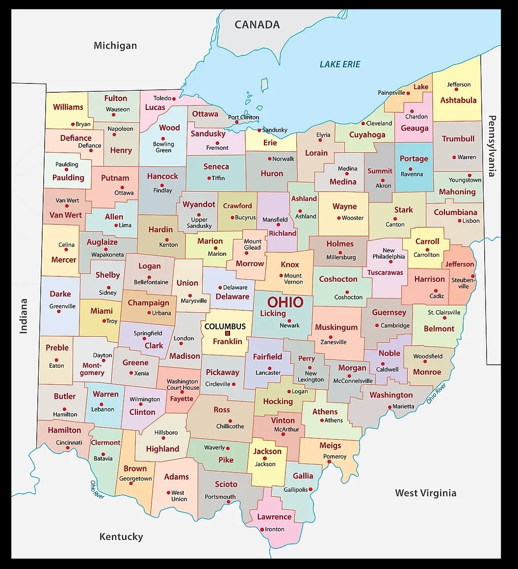
1. Ohio County Map:
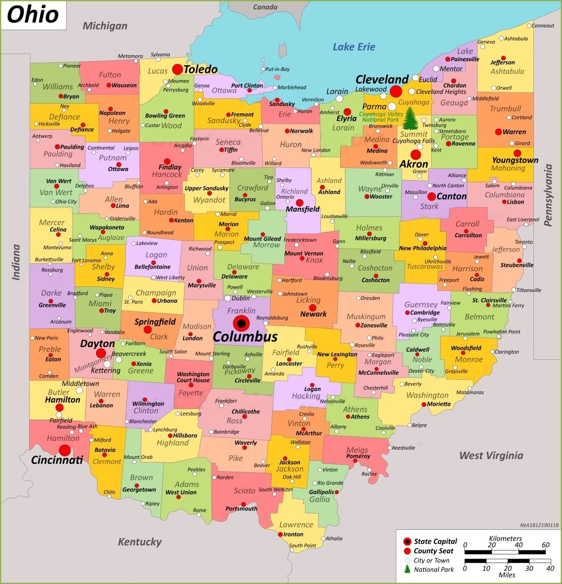
2. Ohio County Map with Cities:
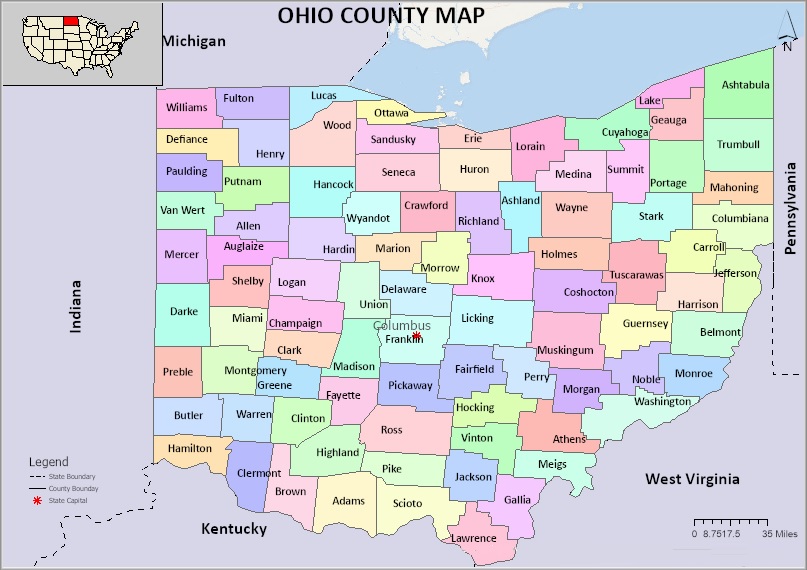
3. County Map of Ohio:
4. Blank County Map of Ohio:
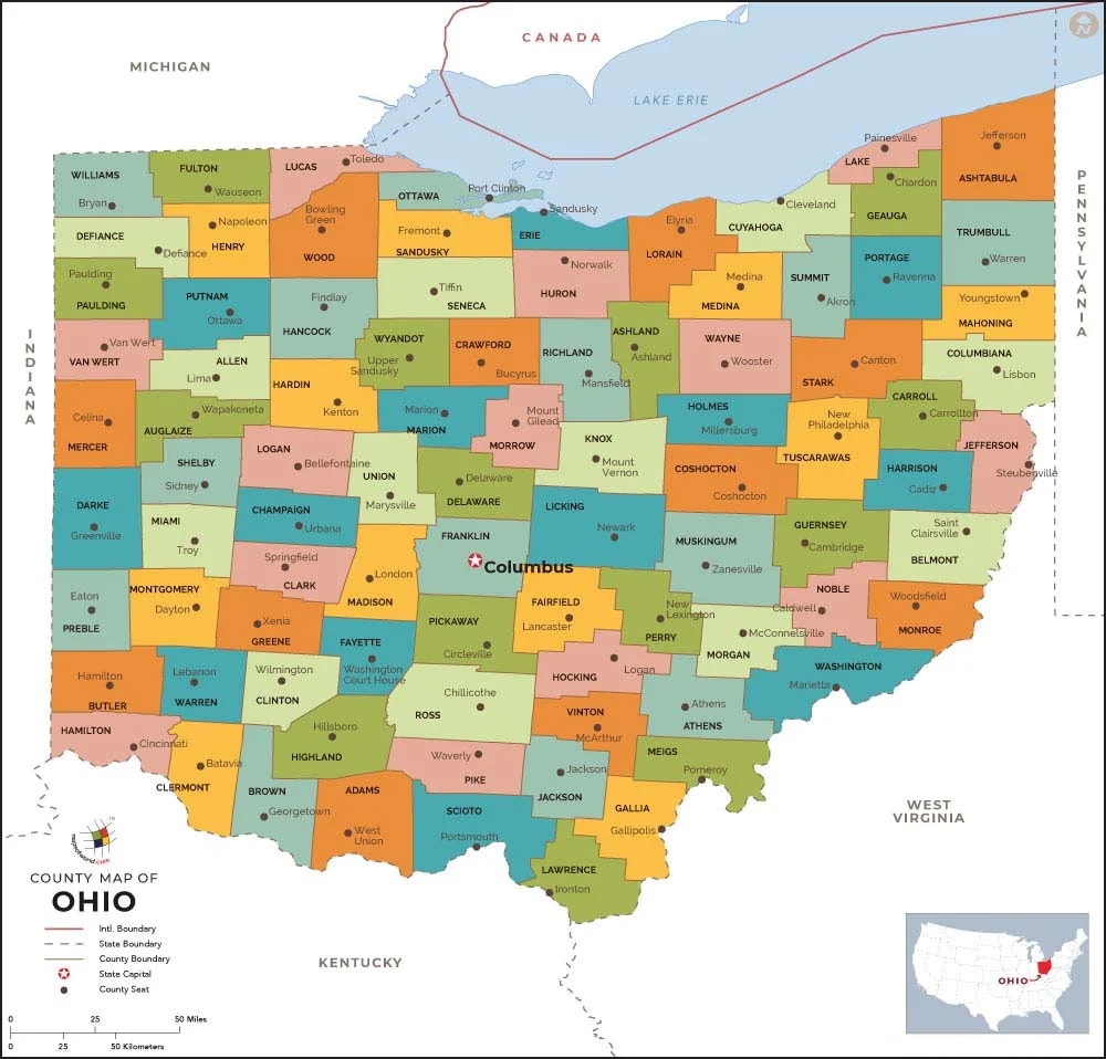
4. OH, USA County Map:
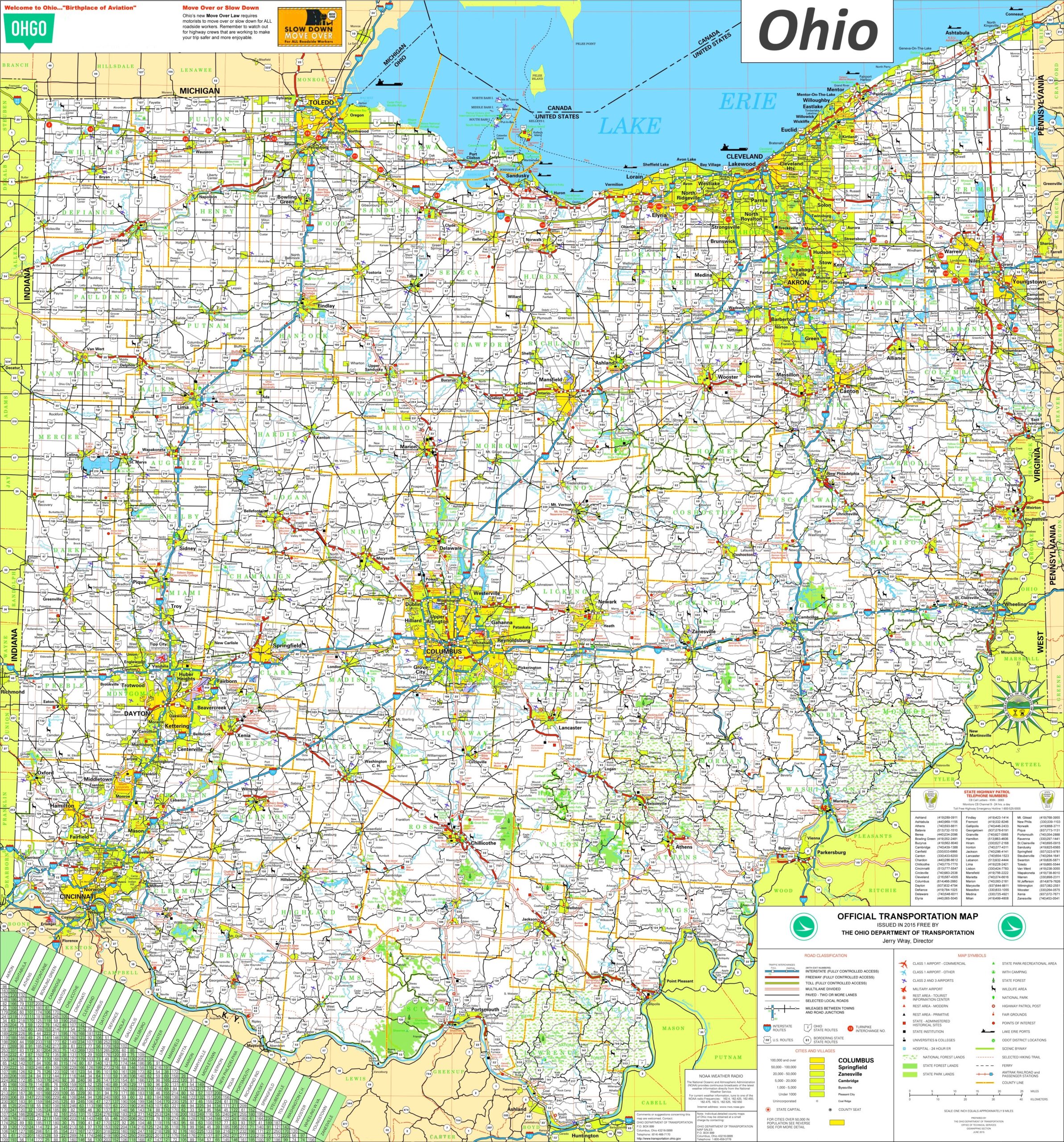
5. Detailed Map of Ohio with Cities and Towns:
6. Map of Ohio:

We have added above this collection of printable and high-quality maps of Ohio County. We have added a total of six different maps that contain helpful information about the counties and cities of Ohio. Below, we are also adding some brief information about each map. So, please read the full description before viewing or saving any map in your device.
The first map is a simple coloured county map of Ohio, which shows only county names. And the next map is a detailed OH county map with cities. So, check this map if you are looking for a full detailed county map of this state. The third map is also a county map, but it differs from the above two maps. It is a simple black and white outline map. Below we are also adding a list that shows some useful information about the counties of this state. Please read the entire table.
List of all Counties in Ohio
This is a list of all counties of Ohio with some helpful and additional information like the name of the county name, year of establishment in, populations, the county seat, and total area.
| County | County Seat | Est. | Population | Area |
| Adams County | West Union | Jul 10, 1797 | 27477 | 583.91 sq mi |
| Allen County | Lima | Mar 1, 1820 | 102206 | 404.43 sq mi |
| Ashland County | Ashland | Feb 24, 1846 | 52447 | 424.37 sq mi |
| Ashtabula County | Jefferson | Jun 7, 1807 | 97574 | 702.44 sq mi |
| Athens County | Athens | Mar 1, 1805 | 62431 | 506.76 sq mi |
| Auglaize County | Wapakoneta | Feb 14, 1848 | 46422 | 401.25 sq mi |
| Belmont County | St. Clairsville | Sep 7, 1801 | 66497 | 537.35 sq mi |
| Brown County | Georgetown | Mar 1, 1818 | 43676 | 491.76 sq mi |
| Butler County | Hamilton | May 1, 1803 | 390357 | 467.27 sq mi |
| Carroll County | Carrollton | Jan 1, 1833 | 26721 | 394.67 sq mi |
| Champaign County | Urbana | Mar 1, 1805 | 38714 | 428.56 sq mi |
| Clark County | Springfield | Mar 1, 1818 | 136001 | 399.86 sq mi |
| Clermont County | Batavia | Dec 6, 1800 | 208601 | 451.99 sq mi |
| Clinton County | Wilmington | Mar 1, 1810 | 42018 | 410.88 sq mi |
| Columbiana County | Lisbon | May 1, 1803 | 101877 | 532.46 sq mi |
| Coshocton County | Coshocton | Jan 31, 1810 | 36612 | 564.07 sq mi |
| Crawford County | Bucyrus | Apr 1, 1820 | 42025 | 402.11 sq mi |
| Cuyahoga County | Cleveland | Jun 7, 1807 | 1264817 | 458.49 sq mi |
| Darke County | Greenville | Jan 3, 1809 | 51881 | 599.80 sq mi |
| Defiance County | Defiance | Apr 7, 1845 | 38286 | 411.16 sq mi |
| Delaware County | Delaware | Apr 1, 1808 | 214124 | 442.41 sq mi |
| Erie County | Sandusky | Mar 15, 1838 | 75622 | 254.88 sq mi |
| Fairfield County | Lancaster | Dec 9, 1800 | 158921 | 505.11 sq mi |
| Fayette County | Washington Court House | Mar 1, 1810 | 28951 | 406.58 sq mi |
| Franklin County | Columbus | Apr 30, 1803 | 1323807 | 539.87 sq mi |
| Fulton County | Wauseon | Apr 1, 1850 | 42713 | 406.78 sq mi |
| Gallia County | Gallipolis | Apr 30, 1803 | 29220 | 468.78 sq mi |
| Geauga County | Chardon | Mar 1, 1806 | 95397 | 403.66 sq mi |
| Greene County | Xenia | May 1, 1803 | 167966 | 414.88 sq mi |
| Guernsey County | Cambridge | Mar 1, 1810 | 38438 | 521.90 sq mi |
| Hamilton County | Cincinnati | Jan 2, 1790 | 830639 | 407.36 sq mi |
| Hancock County | Findlay | Apr 1, 1820 | 74920 | 531.35 sq mi |
| Hardin County | Kenton | Apr 1, 1820 | 30696 | 470.29 sq mi |
| Harrison County | Cadiz | Feb 1, 1813 | 14483 | 403.53 sq mi |
| Henry County | Napoleon | Apr 1, 1820 | 27662 | 416.50 sq mi |
| Highland County | Hillsboro | May 1, 1805 | 43317 | 553.28 sq mi |
| Hocking County | Logan | Mar 1, 1818 | 28050 | 422.75 sq mi |
| Holmes County | Millersburg | Jan 20, 1824 | 44223 | 422.99 sq mi |
| Huron County | Norwalk | Mar 7, 1809 | 58565 | 492.69 sq mi |
| Jackson County | Jackson | Mar 1, 1816 | 32653 | 420.28 sq mi |
| Jefferson County | Steubenville | Jul 29, 1797 | 65249 | 409.61 sq mi |
| Knox County | Mount Vernon | Mar 1, 1808 | 62721 | 527.12 sq mi |
| Lake County | Painesville | Mar 6, 1840 | 232603 | 228.21 sq mi |
| Lawrence County | Ironton | Dec 21, 1815 | 58240 | 454.96 sq mi |
| Licking County | Newark | Mar 1, 1808 | 178519 | 686.50 sq mi |
| Logan County | Bellefontaine | Mar 1, 1818 | 46150 | 458.44 sq mi |
| Lorain County | Elyria | Dec 26, 1822 | 312964 | 492.50 sq mi |
| Lucas County | Toledo | Jun 20, 1835 | 431279 | 340.46 sq mi |
| Madison County | London | Mar 1, 1810 | 43824 | 465.44 sq mi |
| Mahoning County | Youngstown | Mar 1, 1846 | 228614 | 415.25 sq mi |
| Marion County | Marion | Apr 1, 1820 | 65359 | 403.84 sq mi |
| Medina County | Medina | Feb 18, 1812 | 182470 | 423 sq mi |
| Meigs County | Pomeroy | Apr 1, 1819 | 22210 | 429.42 sq mi |
| Mercer County | Celina | Apr 1, 1820 | 42528 | 463.27 sq mi |
| Miami County | Troy | Mar 1, 1807 | 108774 | 407.04 sq mi |
| Monroe County | Woodsfield | Jan 29, 1813 | 13385 | 455.54 sq mi |
| Montgomery County | Dayton | May 1, 1803 | 537309 | 461.68 sq mi |
| Morgan County | McConnelsville | Dec 29, 1817 | 13802 | 417.66 sq mi |
| Morrow County | Mount Gilead | Mar 1, 1848 | 34950 | 406.22 sq mi |
| Muskingum County | Zanesville | Mar 1, 1804 | 86410 | 664.63 sq mi |
| Noble County | Caldwell | Apr 1, 1851 | 14115 | 399.00 sq mi |
| Ottawa County | Port Clinton | Mar 6, 1840 | 40364 | 254.95 sq mi |
| Paulding County | Paulding | Apr 1, 1820 | 18806 | 416.26 sq mi |
| Perry County | New Lexington | Mar 1, 1818 | 35408 | 409.78 sq mi |
| Pickaway County | Circleville | Mar 1, 1810 | 58539 | 501.91 sq mi |
| Pike County | Waverly | Feb 1, 1815 | 27088 | 441.49 sq mi |
| Portage County | Ravenna | Jun 7, 1807 | 161791 | 492.39 sq mi |
| Preble County | Eaton | Mar 1, 1808 | 40999 | 424.80 sq mi |
| Putnam County | Ottawa | Apr 1, 1820 | 34451 | 483.87 sq mi |
| Richland County | Mansfield | Mar 1, 1808 | 124936 | 496.88 sq mi |
| Ross County | Chillicothe | Aug 20, 1798 | 77093 | 688.41 sq mi |
| Sandusky County | Fremont | Apr 1, 1820 | 58896 | 409.18 sq mi |
| Scioto County | Portsmouth | May 1, 1803 | 74008 | 612.27 sq mi |
| Seneca County | Tiffin | Apr 1, 1820 | 55069 | 550.59 sq mi |
| Shelby County | Sidney | Apr 1, 1819 | 48230 | 409.27 sq mi |
| Stark County | Canton | Feb 13, 1808 | 374853 | 576.14 sq mi |
| Summit County | Akron | Mar 3, 1840 | 540428 | 419.38 sq mi |
| Trumbull County | Warren | Jul 10, 1800 | 201977 | 616.48 sq mi |
| Tuscarawas County | New Philadelphia | Mar 15, 1808 | 93263 | 567.58 sq mi |
| Union County | Marysville | Apr 1, 1820 | 62784 | 436.65 sq mi |
| Van Wert County | Van Wert | Apr 1, 1820 | 28931 | 410.09 sq mi |
| Vinton County | McArthur | Mar 23, 1850 | 12800 | 414.08 sq mi |
| Warren County | Lebanon | May 1, 1803 | 242337 | 399.63 sq mi |
| Washington County | Marietta | Jul 27, 1788 | 59771 | 635.15 sq mi |
| Wayne County | Wooster | Mar 1, 1808 | 116894 | 555.36 sq mi |
| Williams County | Bryan | Apr 1, 1820 | 37102 | 421.74 sq mi |
| Wood County | Bowling Green | Apr 1, 1820 | 132248 | 617.32 sq mi |
| Wyandot County | Upper Sandusky | Feb 3, 1845 | 21900 | 405.61 sq mi |
The fourth map is a complete state map of Ohio that shows all counties, major cities, and major rivers and lakes. And the last map is a detailed city and town map of Ohio state. All major cities and towns are visible on this map, with all street roads, national highways, all lakes, rivers are also shown on this map.
So, these were some high-quality and printable maps that we have added above. These large HD maps are available in PDF and JPG (Image) formats. You can easily download any map by clicking on the buttons under the preview image. All these maps are free to download.