Louisiana has 64 parishes (similar to counties). This state is officially Roman Catholic and the boundaries of this state generally coincide with parishes. These parishes are divided into various cities, villages, and boroughs. You can learn more about the counties or parishes of Louisiana with the help of a Louisiana Parishes Map. And, here on this page, we are adding some printable and high-quality parishes maps along with state, cities, and towns maps. Scroll down the page and check our collections of maps related to counties of Louisiana.
Louisiana (LA) Parish Maps Collection:
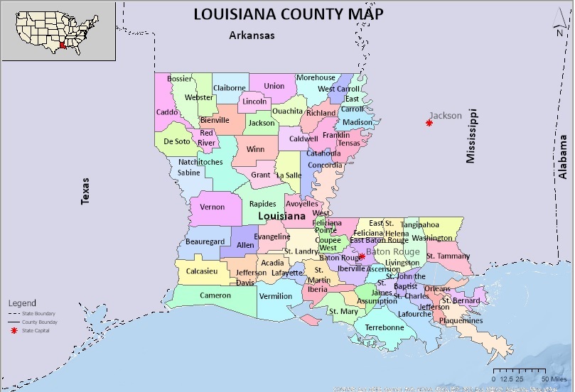
1. Parish Map of Louisiana:
2. Blank Parish Map of Louisiana:

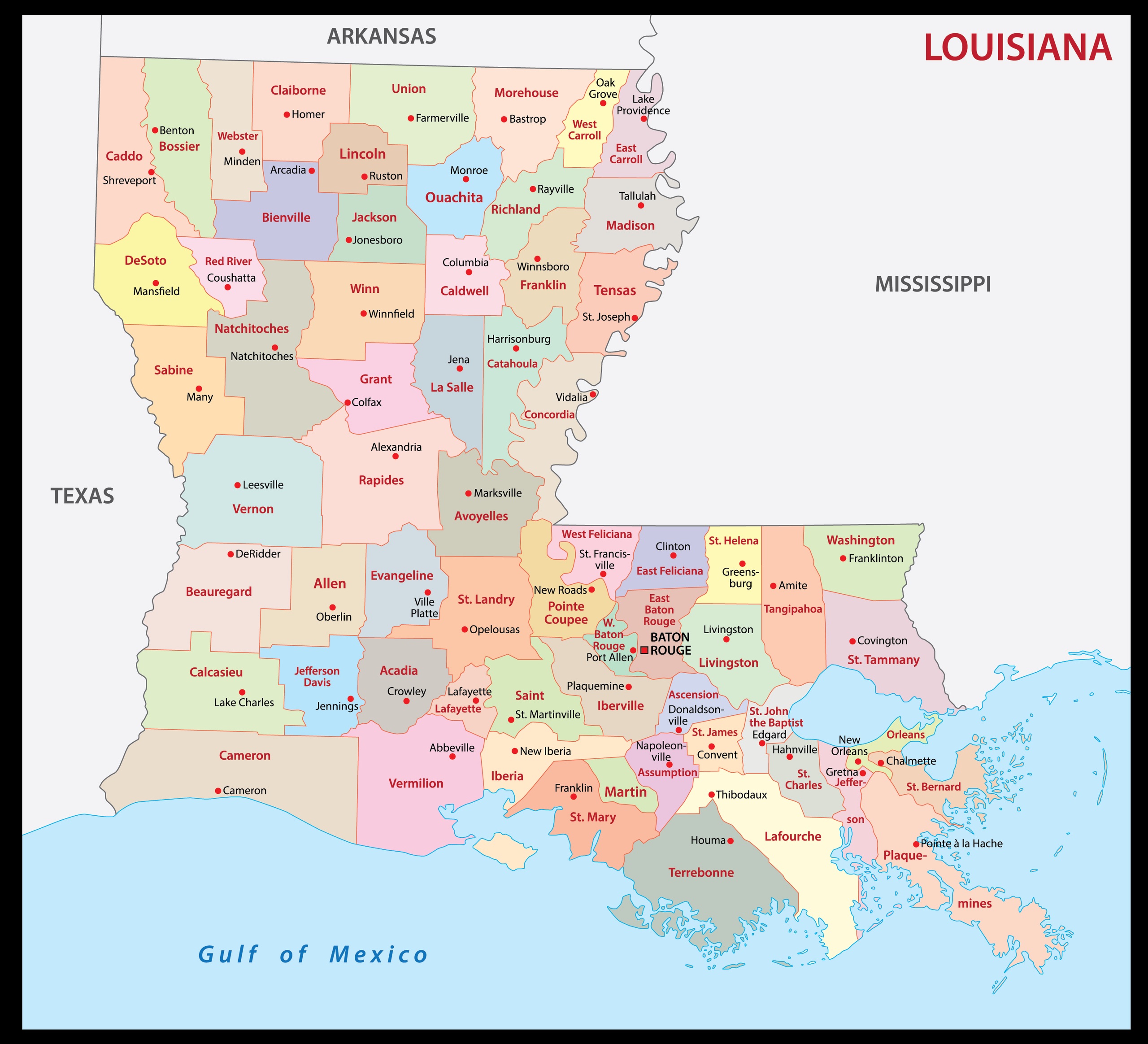
3. Map of Louisiana with Parishes:
4. Louisiana Map:

5. Map of Louisiana Cities & Towns:

This is the collection of some high-quality LA Parish map that we have added above. We have added a total of seven different maps that contain some helpful information about the parishes and cities of Louisiana state. Here, we are adding some brief information about each map. So, please read the full description before downloading any map from the above collection.
The first map is a simple parish map of Louisiana, which shows only the names of parishes. The second map is also a blank or outlined parish map of Louisiana, this map is visually different. And the next map is a detailed county map with cities. So, you can check the second map if you need a detailed parish or county map of this state. Below we are also adding a table that shows some useful information about the parishes of Louisiana. Please read the entire table for additional information.
Parishes in Louisiana, USA:
This is a list of all parishes of this state with some useful information like the name of the Parish, the parish seat, the year of establishment, and the total area.
| Parish | Parish Seat | Est. | Population | Area |
| Allen Parish | Oberlin | 1912 | 22687 | 766 sq mi |
| Ascension Parish | Donaldsonville | 1807 | 128369 | 303 sq mi |
| Assumption Parish | Napoleonville | 1807 | 20689 | 364 sq mi |
| Avoyelles Parish | Marksville | 1807 | 39236 | 866 sq mi |
| Beauregard Parish | DeRidder | 1912 | 36584 | 1,166 sq mi |
| Bienville Parish | Arcadia | 1848 | 12776 | 822 sq mi |
| Bossier Parish | Benton | 1843 | 129144 | 867 sq mi |
| Caddo Parish | Shreveport | 1838 | 233092 | 937 sq mi |
| Calcasieu Parish | Lake Charles | 1840 | 205282 | 1,094 sq mi |
| Caldwell Parish | Columbia | 1838 | 9571 | 541 sq mi |
| Cameron Parish | Cameron | 1870 | 5080 | 1,932 sq mi |
| Catahoula Parish | Harrisonburg | 1808 | 8805 | 739 sq mi |
| Claiborne Parish | Homer | 1828 | 14038 | 768 sq mi |
| Concordia Parish | Vidalia | 1807 | 18376 | 749 sq mi |
| DeSoto Parish | Mansfield | 1843 | 26919 | 895 sq mi |
| East Baton Rouge Parish | Baton Rouge | 1810 | 453301 | 471 sq mi |
| East Carroll Parish | Lake Providence | 1877 | 7220 | 442 sq mi |
| East Feliciana Parish | Clinton | 1824 | 19338 | 456 sq mi |
| Evangeline Parish | Ville Platte | 1910 | 32215 | 680 sq mi |
| Franklin Parish | Winnsboro | 1843 | 19668 | 636 sq mi |
| Grant Parish | Colfax | 1869 | 22236 | 664 sq mi |
| Iberia Parish | New Iberia | 1868 | 68975 | 1,031 sq mi |
| Iberville Parish | Plaquemine | 1807 | 29824 | 653 sq mi |
| Jackson Parish | Jonesboro | 1845 | 14876 | 580 sq mi |
| Jefferson Parish | Gretna | 1825 | 433688 | 642 sq mi |
| Jefferson Davis Parish | Jennings | 1912 | 32345 | 659 sq mi |
| Lafayette Parish | Lafayette | 1823 | 244205 | 270 sq mi |
| Lafourche Parish | Thibodaux | 1807 | 97504 | 1,472 sq mi |
| LaSalle Parish | Jena | 1910 | 14834 | 663 sq mi |
| Lincoln Parish | Ruston | 1873 | 48152 | 472 sq mi |
| Livingston Parish | Livingston | 1832 | 145830 | 703 sq mi |
| Madison Parish | Tallulah | 1838 | 9799 | 651 sq mi |
| Morehouse Parish | Bastrop | 1844 | 25025 | 805 sq mi |
| Natchitoches Parish | Natchitoches | 1807 | 37026 | 1,299 sq mi |
| Orleans Parish | New Orleans | 1807 | 376971 | 350 sq mi |
| Ouachita Parish | Monroe | 1807 | 158768 | 633 sq mi |
| Plaquemines Parish | Pointe à la Hache | 1807 | 23303 | 2,429 sq mi |
| Pointe Coupee Parish | New Roads | 1807 | 20356 | 591 sq mi |
| Rapides Parish | Alexandria | 1807 | 128654 | 1,362 sq mi |
| Red River Parish | Coushatta | 1871 | 7564 | 402 sq mi |
| Richland Parish | Rayville | 1868 | 19805 | 564 sq mi |
| Sabine Parish | Many | 1843 | 22135 | 1,012 sq mi |
| St. Bernard Parish | Chalmette | 1807 | 44258 | 1,794 sq mi |
| St. Charles Parish | Hahnville | 1807 | 52282 | 410 sq mi |
| St. Helena Parish | Greensburg | 1810 | 10912 | 409 sq mi |
| St. James Parish | Convent | 1807 | 19742 | 258 sq mi |
| St. John the Baptist Parish | Edgard | 1807 | 42094 | 348 sq mi |
| St. Landry Parish | Opelousas | 1807 | 82071 | 939 sq mi |
| St. Martin Parish | St. Martinville | 1807 | 51540 | 817 sq mi |
| St. Mary Parish | Franklin | 1811 | 48232 | 612 sq mi |
| St. Tammany Parish | Covington | 1810 | 269388 | 1,124 sq mi |
| Tangipahoa Parish | Amite City | 1869 | 135217 | 823 sq mi |
| Tensas Parish | St. Joseph | 1843 | 4043 | 641 sq mi |
| Terrebonne Parish | Houma | 1822 | 108708 | 2,080 sq mi |
| Union Parish | Farmerville | 1839 | 21091 | 905 sq mi |
| Vermilion Parish | Abbeville | 1844 | 57204 | 1,538 sq mi |
| Vernon Parish | Leesville | 1871 | 48027 | 1,341 sq mi |
| Washington Parish | Franklinton | 1819 | 45133 | 676 sq mi |
| Webster Parish | Minden | 1871 | 36184 | 615 sq mi |
| West Baton Rouge Parish | Port Allen | 1807 | 27792 | 203 sq mi |
| West Carroll Parish | Oak Grove, West Carroll Parish | 1877 | 9594 | 360 sq mi |
| West Feliciana Parish | St. Francisville | 1824 | 15494 | 426 sq mi |
| Winn Parish | Winnfield | 1852 | 13488 | 957 sq mi |
And the fourth map is a detailed map of this state. All major cities and towns are visible on this map with all major roads. And some water bodies like Lakes and Rivers are also shown on this map. The fifth map is a main map of Louisiana with cities that shows all counties, major cities, city roads, and interstate highways. So, these were some printable maps that we have added above. These large maps are available in PDF format and JPG (Image) format. You can easily download any map by clicking on the buttons under the preview image. All these H.D. maps are free to download.