Arkansas is a state, located in the South-Central USA. This state is divided into 75 counties. Arkansas was formed on 15 June 1836 as the 25th state of the USA. Lafayette is the smallest county whereas Union County is the largest county in Arkansas based on area. If you are here to learn more about the counties of Arkansas then you are on the right page. Below, we are adding a county map of Arkansas with a list of counties of Arkansas. Scroll down the page and check everything.
Arkansas (AR) County Maps Collection:
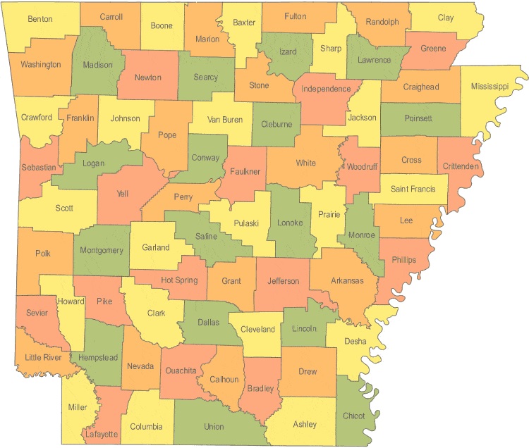
1. County Map of Arkansas:

2. AR County Map:
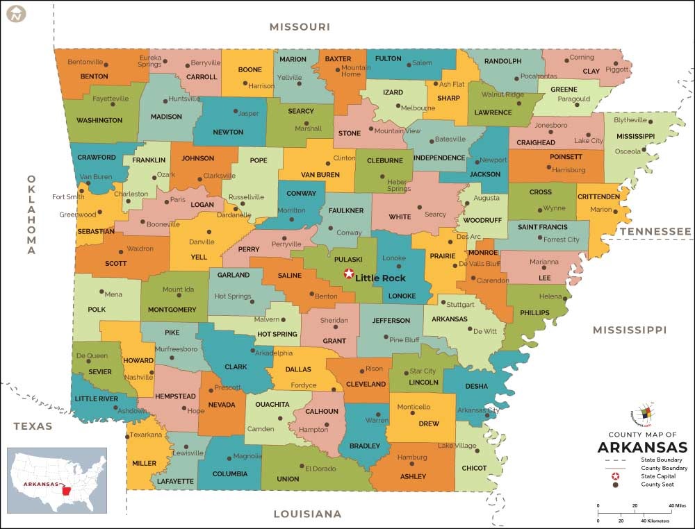
3.County Map of Arkansas with Cities:
4. Cities & Towns Map of Arkansas:

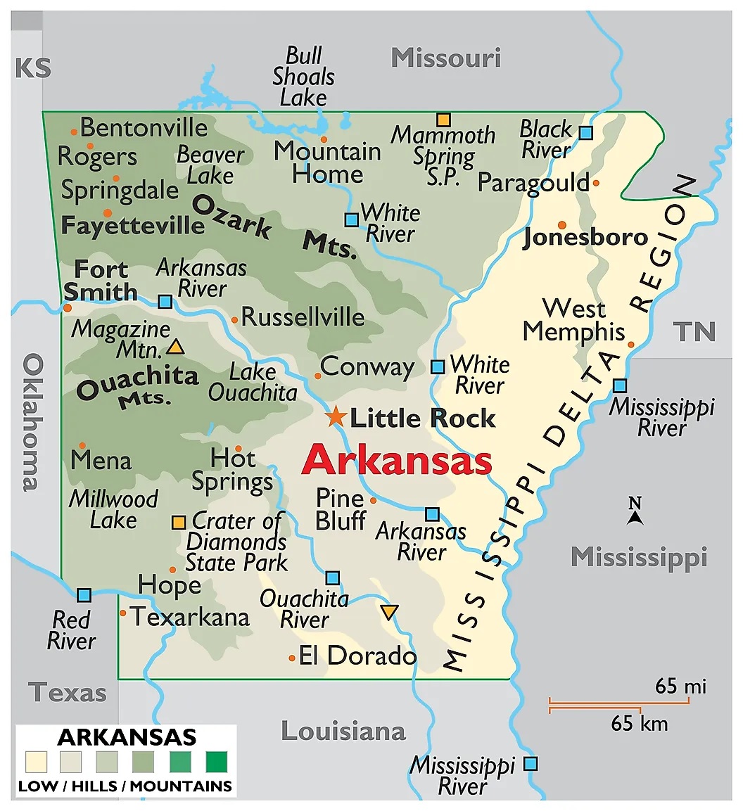
5. Arkansas Map:
Above we have added a total of five maps of Counties in Arkansas state. So, check all these maps and get the correct map you are looking for. And for more detailed and useful information about the Counties, you check the table we are providing below.
List of all Counties that are in Arkansas:
In this table, you will get useful information such as Name of County, Year of Establishment, approx. population, average area, and their county seat of all counties. And, if you are looking for the maps of any county, please check the first three maps.
| County | County Seat | Established | Population | Area |
| Ashley County | Hamburg | 1848 | 21853 | 921 sq mi |
| Baxter County | Mountain Home | 1873 | 41513 | 554 sq mi |
| Benton County | Bentonville | 1836 | 221339 | 843 sq mi |
| Boone County | Harrison | 1869 | 36903 | 591 sq mi |
| Bradley County | Warren | 1840 | 11508 | 651 sq mi |
| Calhoun County | Hampton | 1850 | 5368 | 628 sq mi |
| Carroll County | Berryville and | 1833 | 27446 | 634 sq mi |
| Chicot County | Lake Village | 1823 | 11800 | 644 sq mi |
| Clark County | Arkadelphia | 1818 | 22995 | 866 sq mi |
| Clay County | Piggott and | 1873 | 16083 | 639 sq mi |
| Cleburne County | Heber Springs | 1883 | 25970 | 553 sq mi |
| Cleveland County | Rison | 1873 | 8689 | 598 sq mi |
| Columbia County | Magnolia | 1852 | 24552 | 766 sq mi |
| Conway County | Morrilton | 1825 | 21273 | 556 sq mi |
| Craighead County | Jonesboro and | 1859 | 96443 | 711 sq mi |
| Crawford County | Van Buren | 1820 | 61948 | 596 sq mi |
| Crittenden County | Marion | 1825 | 50902 | 610 sq mi |
| Cross County | Wynne | 1862 | 17870 | 616 sq mi |
| Dallas County | Fordyce | 1845 | 8116 | 668 sq mi |
| Desha County | Arkansas City | 1838 | 13008 | 765 sq mi |
| Drew County | Monticello | 1846 | 18509 | 828 sq mi |
| Faulkner County | Conway | 1873 | 113237 | 647 sq mi |
| Franklin County | Ozark and | 1837 | 18125 | 610 sq mi |
| Fulton County | Salem | 1842 | 12245 | 618 sq mi |
| Garland County | Hot Springs | 1873 | 96024 | 678 sq mi |
| Grant County | Sheridan | 1869 | 17853 | 632 sq mi |
| Greene County | Paragould | 1833 | 42090 | 578 sq mi |
| Hempstead County | Hope | 1818 | 22609 | 729 sq mi |
| Hot Spring County | Malvern | 1829 | 32923 | 615 sq mi |
| Howard County | Nashville | 1873 | 13789 | 588 sq mi |
| Independence County | Batesville | 1820 | 36647 | 764 sq mi |
| Izard County | Melbourne | 1825 | 13696 | 581 sq mi |
| Jackson County | Newport | 1829 | 17997 | 634 sq mi |
| Jefferson County | Pine Bluff | 1829 | 77435 | 885 sq mi |
| Johnson County | Clarksville | 1833 | 25540 | 662 sq mi |
| Lafayette County | Lewisville | 1827 | 7645 | 526 sq mi |
| Lawrence County | Walnut Ridge | 1815 | 17415 | 587 sq mi |
| Lee County | Marianna | 1873 | 10424 | 602 sq mi |
| Lincoln County | Star City | 1871 | 14134 | 561 sq mi |
| Little River County | Ashdown | 1867 | 13171 | 532 sq mi |
| Logan County | Booneville and | 1871 | 22353 | 710 sq mi |
| Lonoke County | Lonoke | 1873 | 68356 | 766 sq mi |
| Madison County | Huntsville | 1836 | 15717 | 837 sq mi |
| Marion County | Yellville | 1835 | 16653 | 598 sq mi |
| Miller County | Texarkana | 1874 | 43462 | 624 sq mi |
| Mississippi County | Blytheville and | 1833[2] | 46480 | 898 sq mi |
| Monroe County | Clarendon | 1839 | 8149 | 607 sq mi |
| Montgomery County | Mount Ida | 1842 | 9487 | 781 sq mi |
| Nevada County | Prescott | 1871 | 8997 | 620 sq mi |
| Newton County | Jasper | 1842 | 8330 | 823 sq mi |
| Ouachita County | Camden | 1842 | 26120 | 732 sq mi |
| Perry County | Perryville | 1840 | 10445 | 551 sq mi |
| Phillips County | Helena-West Helena | 1820 | 21757 | 693 sq mi |
| Pike County | Murfreesboro | 1833 | 11291 | 603 sq mi |
| Poinsett County | Harrisburg | 1838 | 24583 | 758 sq mi |
| Polk County | Mena | 1844 | 20662 | 860 sq mi |
| Pope County | Russellville | 1829 | 61754 | 812 sq mi |
| Prairie County | Des Arc and | 1846 | 8715 | 646 sq mi |
| Pulaski County | Little Rock | 1818 | 382748 | 771 sq mi |
| Randolph County | Pocahontas | 1835 | 17969 | 652 sq mi |
| St. Francis County | Forrest City | 1827 | 28258 | 634 sq mi |
| Saline County | Benton | 1835 | 107118 | 725 sq mi |
| Scott County | Waldron | 1833 | 11233 | 894 sq mi |
| Searcy County | Marshall | 1838 | 8195 | 667 sq mi |
| Sebastian County | Greenwood and | 1851 | 125744 | 536 sq mi |
| Sevier County | De Queen | 1828 | 17058 | 564 sq mi |
| Sharp County | Ash Flat | 1868 | 17264 | 604 sq mi |
| Stone County | Mountain View | 1873 | 12394 | 607 sq mi |
| Union County | El Dorado | 1829 | 41639 | 1,039 sq mi |
| Van Buren County | Clinton | 1833 | 17295 | 712 sq mi |
| Washington County | Fayetteville | 1828 | 203065 | 950 sq mi |
| White County | Searcy | 1835 | 77076 | 1,034 sq mi |
| Woodruff County | Augusta | 1862 | 7260 | 587 sq mi |
| Yell County | Danville | 1840 | 22185 | 928 sq mi |
In the first map, you will see the name of all counties and their location on the Arkansas Map. The second map is a simple county map that shows only county names. Now, the third map is a detailed County map of AR, USA. This map shows counties along with all major cities, the county seat, and towns. So, you can get this map if you have any work related to the Counties of this state.
The fourth map is a detailed and large map of Arkansas’s Cities and Towns. This is a complete and printable map showing all cities, roads, state highways, and their routes. With the help of this map, you can easily move anywhere in any city in this state. The last map is a major state map of Arkansas. This map only shows all counties, cities, mountains, hills, rivers, and lakes. So, these were some printable maps related to Arkansas (AR) county and towns that we have added above. These high-quality maps are available in PDF and JPG formats. You can easily download any map by clicking on the buttons under the preview image. All these maps are free to download.