Louisiana is an amazing state in the USA and is located in the South-Central region of the country. This state has one official nickname that is Pelican State and has two un-officials nicknames which are Bayou State and Creole State. This state has a very popular historical background and also has amazing places to explore and visit. And, if you are a student, explorer, or traveler then you should stay on this page and check or collection of maps because these maps contain useful information that will help you in your study or journey. Now, please scroll down the page, and let’s start with a printable map of Louisiana state. Here, we have also added county maps, cities, and towns maps.
Collections of Louisiana Maps:
1. Louisiana Map:

2. Map of Northern Louisiana:

3. Southern Louisiana Map:

4. Map of Louisiana Cities & Towns:

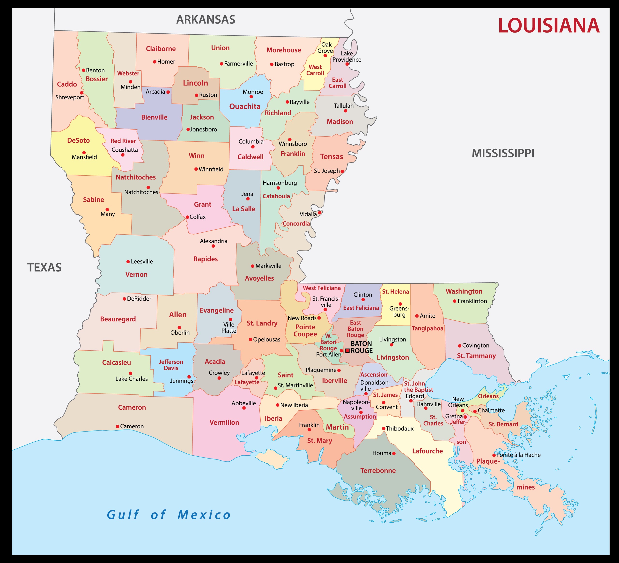
5. Parish Map of Louisiana:
6. Louisiana on US Map:

7. Satellite Map of Louisiana:

8. Blank Map of Louisiana:
This is the collection of the LA USA map that we have added above. We have added a total of eight different maps that contain some helpful information. Below, we are also adding some brief information about each map. So, please read the full description before viewing or downloading any map from the above.
The first map is related to the state map of Louisiana, which shows all counties, towns, and cities on the map. Now the next two maps are the specific regional maps of this state. The second map shows all cities and towns located in Northern Louisiana, and the third map shows all towns, cities, and roads in the Southern region of Louisiana.
The fourth map shows all the cities, towns, counties, and other tourist places. It is a complete and detailed cities and town map of Louisiana state. You can use this map if you are an explorer, traveler, or tourist because, on this map, you can also know about all parks, malls, beaches, airports, railroads, street roads, city roads, interstate highways, U.S. routes, and other states’ highways. The fifth map is related to the parishes map of Louisiana, which shows all parishes (equivalent to counties) and some major cities.
Now, the sixth map shows the location of this state on the country map. As you can see, an area filled with red color indicates LA, USA location. Now, the seventh map is a satellite image of Louisiana that shows the structure of this state. As you can see on the map, a thin yellow line marks the outer boundary. The eighth map is a blank outline map of this state, which shows the boundary of Louisiana.
So, if you are looking for such types of information then you must check this map. These were some most useful and printable Louisiana State Map that we have added above. These high-quality maps are available in PDF format and JPG (Image) format. You can easily download any map by clicking on the buttons under the preview image.