Minnesota is situated in the USA and has 87 counties. Benton County is the oldest and first county in Minnesota which is established in 1849. St. Louis county is the largest county in this state spread over 16,123 km2, it is also the capital city of Minnesota. There are several historical counties in this state. If you are here to learn more about the counties of this state then first you should start with a county map of Minnesota. Below, we are adding some printable maps related to counties and cities of MN. Please scroll down the page and check all the maps.
Minnesota (MN) County Maps Collection:
1. County Map of Minnesota:

2. MN County Maps:

3. County Maps of Minneosta with Cities:

4. Minnesota County Map:

5. Minnesota Map:

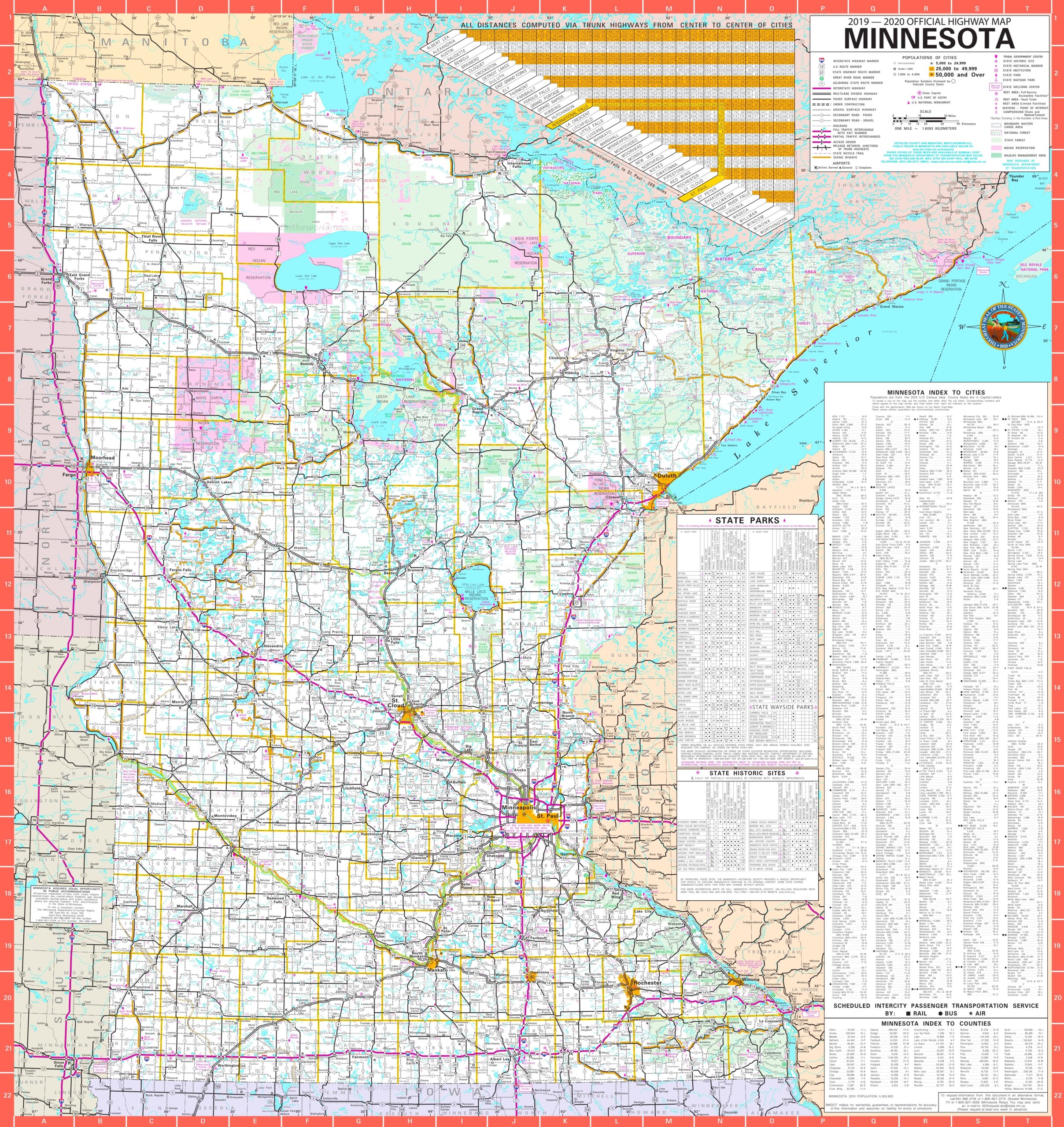
6. Map of Minnesota with Cities:
Here, we have added six types of county maps. Each map contains some useful information. For you, we are also adding some more useful information about each county. So, read the description and save any map for any work or purpose. We are also adding a table that shows some information about the counties of this state.
List of all Counties in the Minnesota, USA (MN):
With the help of this table, you will get some quick information about the counties. And for some additional information, you can check the first map which is a county map of Minnesota.
| S.N | County | County Seat | Population | Area | Formed |
| 1 | Aitkin County | Aitkin | 16202 | 1,819.30 sq mi | 1857 |
| 2 | Anoka County | Anoka | 330844 | 423.61 sq mi | 1857 |
| 3 | Becker County | Detroit Lakes | 32504 | 1,310.42 sq mi | 1858 |
| 4 | Beltrami County | Bemidji | 44442 | 2,505.27 sq mi | 1866 |
| 5 | Benton County | Foley | 38451 | 408.28 sq mi | 1849 |
| 6 | Big Stone County | Ortonville | 5269 | 496.95 sq mi | 1862 |
| 7 | Blue Earth County | Mankato | 64013 | 752.36 sq mi | 1853 |
| 8 | Brown County | New Ulm | 25893 | 610.86 sq mi | 1855 |
| 9 | Carlton County | Carlton | 35386 | 860.33 sq mi | 1857 |
| 10 | Carver County | Chaska | 91042 | 357.04 sq mi | 1855 |
| 11 | Cass County | Walker | 28567 | 2,017.60 sq mi | 1851 |
| 12 | Chippewa County | Montevideo | 12441 | 582.80 sq mi | 1870 |
| 13 | Chisago County | Center City | 53887 | 417.63 sq mi | 1851 |
| 14 | Clay County | Moorhead | 58999 | 1,045.24 sq mi | 1862 |
| 15 | Clearwater County | Bagley | 8695 | 994.71 sq mi | 1902 |
| 16 | Cook County | Grand Marais | 5176 | 1,450.60 sq mi | 1874 |
| 17 | Cottonwood County | Windom | 11687 | 639.99 sq mi | 1857 |
| 18 | Crow Wing County | Brainerd | 62500 | 996.57 sq mi | 1857 |
| 19 | Dakota County | Hastings | 398552 | 569.58 sq mi | 1849 |
| 20 | Dodge County | Mantorville | 20087 | 439.50 sq mi | 1855 |
| 21 | Douglas County | Alexandria | 36009 | 634.32 sq mi | 1858 |
| 22 | Faribault County | Blue Earth | 14553 | 713.63 sq mi | 1855 |
| 23 | Fillmore County | Preston | 20866 | 861.25 sq mi | 1853 |
| 24 | Freeborn County | Albert Lea | 31255 | 707.64 sq mi | 1855 |
| 25 | Goodhue County | Red Wing | 46183 | 758.27 sq mi | 1853 |
| 26 | Grant County | Elbow Lake | 6018 | 546.41 sq mi | 1868 |
| 27 | Hennepin County | Minneapolis | 1152425 | 556.62 sq mi | 1852 |
| 28 | Houston County | Caledonia | 19027 | 558.41 sq mi | 1854 |
| 29 | Hubbard County | Park Rapids | 20428 | 922.46 sq mi | 1883 |
| 30 | Isanti County | Cambridge | 37816 | 439.07 sq mi | 1857 |
| 31 | Itasca County | Grand Rapids | 45058 | 2,665.06 sq mi | 1849 |
| 32 | Jackson County | Jackson | 10266 | 701.69 sq mi | 1857 |
| 33 | Kanabec County | Mora | 16239 | 524.93 sq mi | 1858 |
| 34 | Kandiyohi County | Willmar | 42239 | 796.06 sq mi | 1858 |
| 35 | Kittson County | Hallock | 4552 | 1,097.08 sq mi | 1879 |
| 36 | Koochiching County | International Falls | 13311 | 3,102.36 sq mi | 1906 |
| 37 | Lac qui Parle County | Madison | 7259 | 764.87 sq mi | 1871 |
| 38 | Lake County | Two Harbors | 10866 | 2,099.16 sq mi | 1856 |
| 39 | Lake of the Woods County | Baudette | 4045 | 1,296.70 sq mi | 1923 |
| 40 | Le Sueur County | Le Center | 27703 | 448.50 sq mi | 1853 |
| 41 | Lincoln County | Ivanhoe | 5896 | 537.03 sq mi | 1873 |
| 42 | Lyon County | Marshall | 25857 | 714.17 sq mi | 1871 |
| 43 | Mahnomen County | Mahnomen | 5413 | 556.14 sq mi | 1906 |
| 44 | Marshall County | Warren | 9439 | 1,772.24 sq mi | 1879 |
| 45 | Martin County | Fairmont | 20840 | 709.34 sq mi | 1857 |
| 46 | McLeod County | Glencoe | 36651 | 491.91 sq mi | 1856 |
| 47 | Meeker County | Litchfield | 23300 | 608.54 sq mi | 1856 |
| 48 | Mille Lacs County | Milaca | 26097 | 574.47 sq mi | 1857 |
| 49 | Morrison County | Little Falls | 33198 | 1,124.50 sq mi | 1856 |
| 50 | Mower County | Austin | 39163 | 711.50 sq mi | 1855 |
| 51 | Murray County | Slayton | 8725 | 704.43 sq mi | 1857 |
| 52 | Nicollet County | St. Peter | 32727 | 452.29 sq mi | 1853 |
| 53 | Nobles County | Worthington | 21378 | 715.39 sq mi | 1857 |
| 54 | Norman County | Ada | 6852 | 876.27 sq mi | 1881 |
| 55 | Olmsted County | Rochester | 144248 | 653.01 sq mi | 1855 |
| 56 | Otter Tail County | Fergus Falls | 57303 | 1,979.71 sq mi | 1858 |
| 57 | Pennington County | Thief River Falls | 13930 | 616.54 sq mi | 1910 |
| 58 | Pine County | Pine City | 29750 | 1,411.04 sq mi | 1856 |
| 59 | Pipestone County | Pipestone | 9596 | 465.89 sq mi | 1857 |
| 60 | Polk County | Crookston | 31600 | 1,970.37 sq mi | 1858 |
| 61 | Pope County | Glenwood | 10995 | 670.14 sq mi | 1862 |
| 62 | Ramsey County | Saint Paul | 508640 | 155.78 sq mi | 1849 |
| 63 | Red Lake County | Red Lake Falls | 4089 | 432.43 sq mi | 1896 |
| 64 | Redwood County | Redwood Falls | 16059 | 879.73 sq mi | 1862 |
| 65 | Renville County | Olivia | 15730 | 982.92 sq mi | 1855 |
| 66 | Rice County | Faribault | 64142 | 497.57 sq mi | 1853 |
| 67 | Rock County | Luverne | 9687 | 482.61 sq mi | 1857 |
| 68 | Roseau County | Roseau | 15629 | 1,662.51 sq mi | 1894 |
| 69 | Saint Louis County | Duluth | 200226 | 6,225.16 sq mi | 1855 |
| 70 | Scott County | Shakopee | 129928 | 356.68 sq mi | 1853 |
| 71 | Sherburne County | Elk River | 88499 | 436.30 sq mi | 1856 |
| 72 | Sibley County | Gaylord | 15226 | 588.65 sq mi | 1853 |
| 73 | Stearns County | St. Cloud | 150642 | 1,344.52 sq mi | 1855 |
| 74 | Steele County | Owatonna | 36576 | 429.55 sq mi | 1855 |
| 75 | Stevens County | Morris | 9726 | 562.06 sq mi | 1862 |
| 76 | Swift County | Benson | 9783 | 743.53 sq mi | 1870 |
| 77 | Todd County | Long Prairie | 24895 | 942.02 sq mi | 1855 |
| 78 | Traverse County | Wheaton | 3558 | 574.09 sq mi | 1862 |
| 79 | Wabasha County | Wabasha | 21676 | 525.01 sq mi | 1849 |
| 80 | Wadena County | Wadena | 13843 | 535.02 sq mi | 1858 |
| 81 | Waseca County | Waseca | 19136 | 423.25 sq mi | 1857 |
| 82 | Washington County | Stillwater | 238136 | 391.70 sq mi | 1849 |
| 83 | Watonwan County | St. James | 11211 | 434.51 sq mi | 1860 |
| 84 | Wilkin County | Breckenridge | 6576 | 751.43 sq mi | 1858 |
| 85 | Winona County | Winona | 51461 | 626.30 sq mi | 1854 |
| 86 | Wright County | Buffalo | 124700 | 660.75 sq mi | 1855 |
| 87 | Yellow Medicine County | Granite Falls | 10438 | 757.96 sq mi | 1871 |
In the first map, you will see the name of all counties and their location on the Minnesota Map. It is the main county map of Minnesota state. Now, the second map is a detailed MN county map. This map shows counties along with all major cities and towns. So, you can get this map if you have any work related to the Counties of this state. The third map is also related to its counties, but it shows the county seats of Minnesota. For more information on County seats, you can check the table that we have added above. Finally, the next map is also a county map, but this map is visibly different.
The fifth map is a simple state map of Minnesota. This map only shows all counties, cities, mountains, hills, rivers, and lakes. The sixth map is a detailed and large map of Minnesota’s Cities and Towns. It is a complete and printable map showing all cities, roads, state highways, and routes. With the help of this map, you can easily move anywhere in any city in Minnesota. So, these were some printable maps related to Minnesota county and towns that we have added above. These high-quality maps are available in PDF and JPG formats. You can easily download any map by clicking on the buttons under the preview image. All these maps are free to download.