Wisconsin is a state in the USA that has 72 counties. Among all counties, Marathon County is the largest county that covering an area of 4,001 km2 and Pepin County is the smallest county based on the area, this county covers an area of 601 km2 including water and land area. Here, on this page, we are providing some useful information about each county along with a county map of Wisconsin. So, if you are here to learn more about the counties of Wisconsin then you are on the right page. Please, scroll down the page to get all information and to check our collection of maps.
Wisconsin (WI) County Maps Collection:
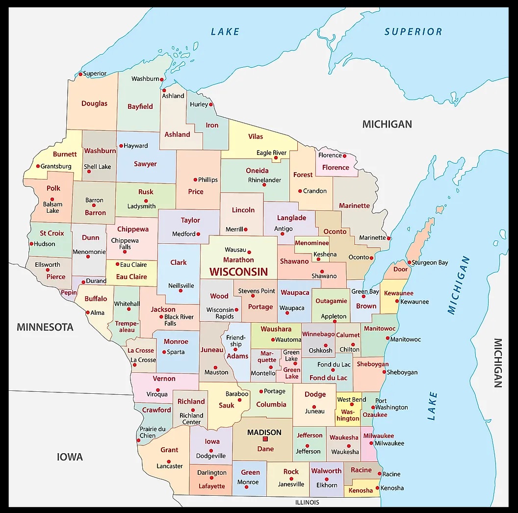
1. County Map of Wisconsin:
2. County line of Wisconsin:

3. County Map of Wisconsin with Cities:

4. Wisconsin Map with Cities and Towns:

5. Wisconsin Map:

Above we have added a total of five maps of Counties in Wisconsin state. So, check all these maps and get the correct map you are looking for. And for more detailed and useful information about the Counties, you check the table we are providing below.
List of all Counties that are in Wisconsin:
In this table, you will get useful information such as Name of County, Year of Establishment, approx. population, average area, and their county seat of all counties. And, if you are looking for the maps of any county, please check the first three maps.
| S.N | County | County Seat | Population | Area (sq. mi.) |
| 1 | Adams County | Friendship | 18643 | 647.74 |
| 2 | Ashland County | Ashland | 16866 | 1043.82 |
| 3 | Barron County | Barron | 44963 | 862.84 |
| 4 | Bayfield County | Washburn | 15013 | 1476.25 |
| 5 | Brown County | Green Bay | 226778 | 528.68 |
| 6 | Buffalo County | Alma | 13804 | 684.47 |
| 7 | Burnett County | Siren | 15674 | 821.52 |
| 8 | Calumet County | Chilton | 40631 | 319.84 |
| 9 | Chippewa County | Chippewa Falls | 55195 | 1010.43 |
| 10 | Clark County | Neillsville | 33557 | 1215.64 |
| 11 | Columbia County | Portage | 52468 | 773.79 |
| 12 | Crawford County | Prairie du Chien | 17243 | 572.69 |
| 13 | Dane County | Madison | 426526 | 1201.89 |
| 14 | Dodge County | Juneau | 85897 | 882.28 |
| 15 | Door County | Sturgeon Bay | 27961 | 482.72 |
| 16 | Douglas County | Superior | 43287 | 1309.13 |
| 17 | Dunn County | Menomonie | 39858 | 852.03 |
| 18 | Eau Claire County | Eau Claire | 93142 | 637.64 |
| 19 | Florence County | Florence | 5088 | 488.03 |
| 20 | Fond du Lac County | Fond du Lac | 97296 | 722.91 |
| 21 | Forest County | Crandon | 10024 | 1014.05 |
| 22 | Grant County | Lancaster | 49597 | 1147.85 |
| 23 | Green County | Monroe | 33647 | 583.99 |
| 24 | Green Lake County | Green Lake | 19105 | 354.28 |
| 25 | Iowa County | Dodgeville | 22780 | 762.67 |
| 26 | Iron County | Hurley | 6861 | 757.23 |
| 27 | Jackson County | Black River Falls | 19100 | 987.32 |
| 28 | Jefferson County | Jefferson | 74021 | 557.01 |
| 29 | Juneau County | Mauston | 24316 | 767.61 |
| 30 | Kenosha County | Kenosha | 149577 | 272.83 |
| 31 | Kewaunee County | Kewaunee | 20187 | 342.64 |
| 32 | La Crosse County | La Crosse | 107120 | 452.74 |
| 33 | Lafayette County | Darlington | 16137 | 633.57 |
| 34 | Langlade County | Antigo | 20740 | 872.67 |
| 35 | Lincoln County | Merrill | 29641 | 883.3 |
| 36 | Manitowoc County | Manitowoc | 82887 | 591.53 |
| 37 | Marathon County | Wausau | 125834 | 1544.96 |
| 38 | Marinette County | Marinette | 43384 | 1401.76 |
| 39 | Marquette County | Montello | 15832 | 455.49 |
| 40 | Menominee County | Keshena | 4562 | 357.96 |
| 41 | Milwaukee County | Milwaukee | 940164 | 241.56 |
| 42 | Monroe County | Sparta | 40899 | 900.77 |
| 43 | Oconto County | Oconto | 35634 | 997.97 |
| 44 | Oneida County | Rhinelander | 36776 | 1124.5 |
| 45 | Outagamie County | Appleton | 160971 | 640.34 |
| 46 | Ozaukee County | Port Washington | 82317 | 231.95 |
| 47 | Pepin County | Durand | 7213 | 232.28 |
| 48 | Pierce County | Ellsworth | 36804 | 576.49 |
| 49 | Polk County | Balsam Lake | 41319 | 917.27 |
| 50 | Portage County | Stevens Point | 67182 | 806.31 |
| 51 | Price County | Phillips | 15822 | 1252.56 |
| 52 | Racine County | Racine | 188831 | 333.1 |
| 53 | Richland County | Richland Center | 17924 | 586.2 |
| 54 | Rock County | Janesville | 152307 | 720.47 |
| 55 | Rusk County | Ladysmith | 15347 | 913.13 |
| 56 | St. Croix County | Baraboo | 63155 | 721.82 |
| 57 | Sauk County | Hayward | 55225 | 837.63 |
| 58 | Sawyer County | Shawano | 16196 | 1256.42 |
| 59 | Shawano County | Sheboygan | 40664 | 892.51 |
| 60 | Sheboygan County | Hudson | 112646 | 513.63 |
| 61 | Taylor County | Medford | 19680 | 974.86 |
| 62 | Trempealeau County | Whitehall | 27010 | 734.08 |
| 63 | Vernon County | Viroqua | 28056 | 794.87 |
| 64 | Vilas County | Eagle River | 21033 | 873.72 |
| 65 | Walworth County | Elkhorn | 93759 | 555.31 |
| 66 | Washburn County | Shell Lake | 16036 | 809.68 |
| 67 | Washington County | West Bend | 117493 | 430.82 |
| 68 | Waukesha County | Waukesha | 360767 | 555.58 |
| 69 | Waupaca County | Waupaca | 51731 | 751.09 |
| 70 | Waushara County | Wautoma | 23154 | 626.03 |
| 71 | Winnebago County | Oshkosh | 156763 | 438.58 |
| 72 | Wood County | Wisconsin Rapids | 75555 | 792.78 |
In the first map, you will see the name of all counties and their location on the Wisconsin Map. The second map is a simple county map that shows the outline of all counties. This type of map is also known as a blank map or outline map. Now, the third map is a detailed County map of WI, USA. This map shows counties along with all major cities, the county seat, and towns. So, you can get this map if you have any work related to the Counties of this state.
The fourth map is a detailed and large map of Wisconsin’s Cities and Towns. This is a complete and printable map showing all cities, roads, state highways, and their routes. With the help of this map, you can easily move anywhere in any city in this state. The last map is a major state map of Wisconsin. This map only shows all counties, cities, mountains, hills, rivers, and lakes. So, these were some printable maps related to Wisconsin (WI) county and towns that we have added above. These high-quality maps are available in PDF and JPG formats. You can easily download any map by clicking on the buttons under the preview image. All these maps are free to download.