Missouri is a US state which is part of a Mid-Western region of the USA. Missouri is surrounded by the eight other states in the country. This state is divided into 114 counties that are further divided into various cities and towns. Here, on this page, we are adding printable maps related to the counties of Missouri. These maps are very useful and a county map of Missouri, USA would be helpful to learn about the counties. So, please scroll down the page and check our collections of maps.
Missouri (MO) County Maps Collection:
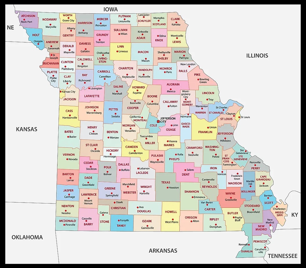
1. County Map of Missouri:
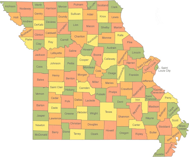
2. MO County Map:
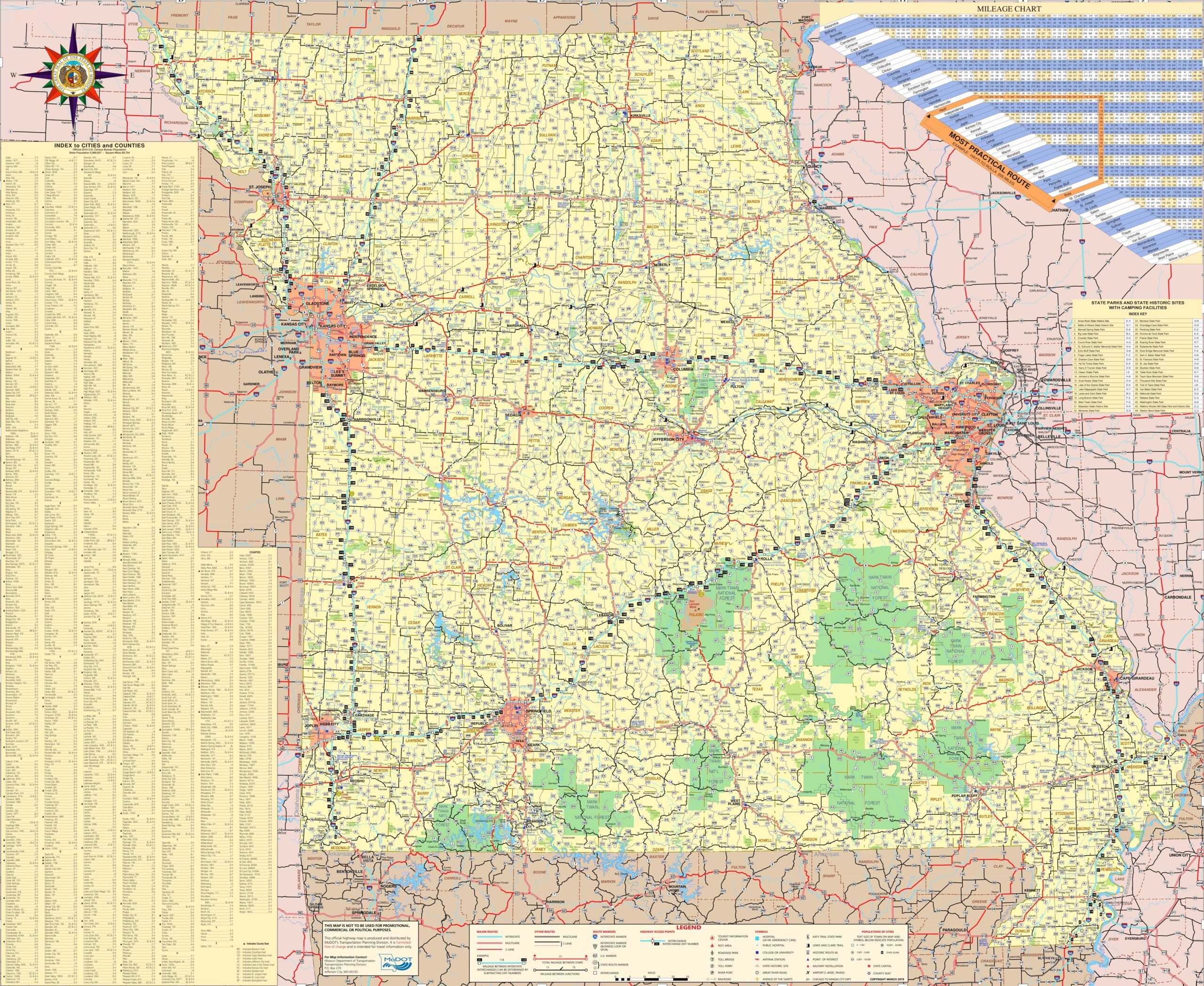
3. County Map of Missouri with Cities:

4. Missouri Map with Cities and Towns:
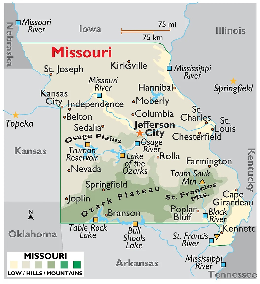
5. Map of Missouri:
Here, we have added five different types of county maps. Each map contains some useful information. For you, we are also adding some more useful information about each county. So, read the description and save any map for any purpose. We are also adding a specific table that shows some information about the counties of Missouri.
List of all Counties in Missouri
With the help of this table, you will learn all about the counties. And for some additional information, you can check the county map of this state.
| S. N | County | County Seat | Population | Area | Formed |
| 1 | Adair County | Kirksville | 25607 | 568 sq mi | 1841 |
| 2 | Andrew County | Savannah | 17291 | 435 sq mi | 1841 |
| 3 | Atchison County | Rock Port | 5685 | 545 sq mi | 1843 |
| 4 | Audrain County | Mexico | 25529 | 693 sq mi | 1831 |
| 5 | Barry County | Cassville | 35597 | 779 sq mi | 1835 |
| 6 | Barton County | Lamar | 12402 | 594 sq mi | 1855 |
| 7 | Bates County | Butler | 17049 | 848 sq mi | 1841 |
| 8 | Benton County | Warsaw | 19056 | 706 sq mi | 1835 |
| 9 | Bollinger County | Marble Hill | 12363 | 621 sq mi | 1851 |
| 10 | Boone County | Columbia | 162642 | 685 sq mi | 1821 |
| 11 | Buchanan County | Saint Joseph | 89201 | 410 sq mi | 1838 |
| 12 | Butler County | Poplar Bluff | 42794 | 698 sq mi | 1849 |
| 13 | Caldwell County | Kingston | 9424 | 429 sq mi | 1836 |
| 14 | Callaway County | Fulton | 44332 | 839 sq mi | 1821 |
| 15 | Camden County | Camdenton | 44002 | 655 sq mi | 1841 |
| 16 | Cape Girardeau County | Jackson | 75674 | 579 sq mi | 1812 |
| 17 | Carroll County | Carrollton | 9295 | 695 sq mi | 1833 |
| 18 | Carter County | Van Buren | 6265 | 508 sq mi | 1859 |
| 19 | Cass County | Harrisonville | 99478 | 699 sq mi | 1833 |
| 20 | Cedar County | Stockton | 13982 | 476 sq mi | 1845 |
| 21 | Chariton County | Keytesville | 7831 | 756 sq mi | 1821 |
| 22 | Christian County | Ozark | 77422 | 563 sq mi | 1859 |
| 23 | Clark County | Kahoka | 7139 | 507 sq mi | 1836 |
| 24 | Clay County | Liberty | 221939 | 396 sq mi | 1822 |
| 25 | Clinton County | Plattsburg | 20743 | 419 sq mi | 1833 |
| 26 | Cole County | Jefferson City | 75990 | 392 sq mi | 1820 |
| 27 | Cooper County | Boonville | 17601 | 565 sq mi | 1818 |
| 28 | Crawford County | Steelville | 24696 | 743 sq mi | 1829 |
| 29 | Dade County | Greenfield | 7883 | 490 sq mi | 1841 |
| 30 | Dallas County | Buffalo | 16777 | 542 sq mi | 1841 |
| 31 | Daviess County | Gallatin | 8433 | 567 sq mi | 1836 |
| 32 | DeKalb County | Maysville | 12892 | 424 sq mi | 1843 |
| 33 | Dent County | Salem | 15657 | 754 sq mi | 1851 |
| 34 | Douglas County | Ava | 13684 | 815 sq mi | 1857 |
| 35 | Dunklin County | Kennett | 31953 | 546 sq mi | 1843 |
| 36 | Franklin County | Union | 101492 | 922 sq mi | 1818 |
| 37 | Gasconade County | Hermann | 15222 | 520 sq mi | 1821 |
| 38 | Gentry County | Albany | 6738 | 492 sq mi | 1841 |
| 39 | Greene County | Springfield | 275174 | 675 sq mi | 1833 |
| 40 | Grundy County | Trenton | 10261 | 436 sq mi | 1839 |
| 41 | Harrison County | Bethany | 8957 | 725 sq mi | 1843 |
| 42 | Henry County | Clinton | 22272 | 702 sq mi | 1834 |
| 43 | Hickory County | Hermitage | 9627 | 399 sq mi | 1845 |
| 44 | Holt County | Oregon | 4912 | 462 sq mi | 1841 |
| 45 | Howard County | Fayette | 10144 | 466 sq mi | 1816 |
| 46 | Howell County | West Plains | 40400 | 928 sq mi | 1857 |
| 47 | Iron County | Ironton | 10630 | 551 sq mi | 1857 |
| 48 | Jackson County | Kansas City, | 674158 | 605 sq mi | 1826 |
| 49 | Jasper County | Carthage | 117404 | 640 sq mi | 1841 |
| 50 | Jefferson County | Hillsboro | 218733 | 657 sq mi | 1818 |
| 51 | Johnson County | Warrensburg | 52595 | 831 sq mi | 1834 |
| 52 | Knox County | Edina | 4131 | 506 sq mi | 1843 |
| 53 | Laclede County | Lebanon | 35571 | 766 sq mi | 1849 |
| 54 | Lafayette County | Lexington | 33381 | 629 sq mi | 1821 |
| 55 | Lawrence County | Mount Vernon | 38634 | 613 sq mi | 1843 |
| 56 | Lewis County | Monticello | 10211 | 505 sq mi | 1833 |
| 57 | Lincoln County | Troy | 52566 | 630 sq mi | 1818 |
| 58 | Linn County | Linneus | 12761 | 620 sq mi | 1837 |
| 59 | Livingston County | Chillicothe | 15195 | 535 sq mi | 1837 |
| 60 | Macon County | Macon | 15566 | 804 sq mi | 1837 |
| 61 | Madison County | Fredericktown | 12226 | 497 sq mi | 1818 |
| 62 | Maries County | Vienna | 9176 | 528 sq mi | 1855 |
| 63 | Marion County | Palmyra | 28781 | 438 sq mi | 1826 |
| 64 | McDonald County | Pineville | 23083 | 540 sq mi | 1847 |
| 65 | Mercer County | Princeton | 3785 | 454 sq mi | 1845 |
| 66 | Miller County | Tuscumbia | 24748 | 592 sq mi | 1837 |
| 67 | Mississippi County | Charleston | 14358 | 413 sq mi | 1842 |
| 68 | Moniteau County | California | 15607 | 417 sq mi | 1845 |
| 69 | Monroe County | Paris | 8840 | 646 sq mi | 1831 |
| 70 | Montgomery County | Montgomery City | 12236 | 539 sq mi | 1818 |
| 71 | Morgan County | Versailles | 20565 | 598 sq mi | 1833 |
| 72 | New Madrid County | New Madrid | 18956 | 678 sq mi | 1812 |
| 73 | Newton County | Neosho | 58114 | 626 sq mi | 1838 |
| 74 | Nodaway County | Maryville | 23370 | 877 sq mi | 1843 |
| 75 | Oregon County | Alton | 10881 | 792 sq mi | 1841 |
| 76 | Osage County | Linn | 13878 | 606 sq mi | 1841 |
| 77 | Ozark County | Gainesville | 9723 | 747 sq mi | 1841 |
| 78 | Pemiscot County | Caruthersville | 18296 | 493 sq mi | 1851 |
| 79 | Perry County | Perryville | 18971 | 475 sq mi | 1821 |
| 80 | Pettis County | Sedalia | 42201 | 685 sq mi | 1833 |
| 81 | Phelps County | Rolla | 45156 | 673 sq mi | 1857 |
| 82 | Pike County | Bowling Green | 18516 | 673 sq mi | 1818 |
| 83 | Platte County | Platte City | 89322 | 420 sq mi | 1838 |
| 84 | Polk County | Bolivar | 31137 | 637 sq mi | 1835 |
| 85 | Pulaski County | Waynesville | 52274 | 547 sq mi | 1833 |
| 86 | Putnam County | Unionville | 4979 | 518 sq mi | 1843 |
| 87 | Ralls County | New London | 10167 | 471 sq mi | 1821 |
| 88 | Randolph County | Huntsville | 25414 | 482 sq mi | 1829 |
| 89 | Ray County | Richmond | 23494 | 570 sq mi | 1820 |
| 90 | Reynolds County | Centerville | 6696 | 811 sq mi | 1845 |
| 91 | Ripley County | Doniphan | 14100 | 630 sq mi | 1831 |
| 92 | Saint Charles County | Saint Charles | 360485 | 561 sq mi | 1812 |
| 93 | Saint Clair County | Osceola | 9805 | 677 sq mi | 1841 |
| 94 | Saint Francois County | Farmington | 65359 | 450 sq mi | 1821 |
| 95 | Saint Louis City | St. Louis | 319294 | 61.9 sq mi | 1876 |
| 96 | Saint Louis County | Clayton | 1000438 | 508 sq mi | 1812 |
| 97 | Saline County | Marshall | 23370 | 756 sq mi | 1820 |
| 98 | Schuyler County | Lancaster | 4431 | 308 sq mi | 1843 |
| 99 | Scotland County | Memphis | 4843 | 438 sq mi | 1841 |
| 100 | Scott County | Benton | 39191 | 421 sq mi | 1822 |
| 101 | Shannon County | Eminence | 8441 | 1,004 sq mi | 1837 |
| 102 | Shelby County | Shelbyville | 6373 | 501 sq mi | 1835 |
| 103 | Ste. Genevieve County | Ste. Genevieve | 18145 | 502 sq mi | 1812 |
| 104 | Stoddard County | Bloomfield | 29968 | 827 sq mi | 1835 |
| 105 | Stone County | Galena | 32202 | 463 sq mi | 1851 |
| 106 | Sullivan County | Milan | 6714 | 651 sq mi | 1843 |
| 107 | Taney County | Forsyth | 51675 | 632 sq mi | 1837 |
| 108 | Texas County | Houston | 26008 | 1,179 sq mi | 1843 |
| 109 | Vernon County | Nevada | 21159 | 834 sq mi | 1851 |
| 110 | Warren County | Warrenton | 32513 | 432 sq mi | 1833 |
| 111 | Washington County | Potosi | 25195 | 760 sq mi | 1813 |
| 112 | Wayne County | Greenville | 13521 | 761 sq mi | 1818 |
| 113 | Webster County | Marshfield | 36202 | 593 sq mi | 1855 |
| 114 | Worth County | Grant City | 2171 | 266 sq mi | 1861 |
| 115 | Wright County | Hartville | 18815 | 682 sq mi | 1841 |
In the first map, you will see the name of all counties and their location on the Missouri Map. The second map is a simple county map that shows the outline of all counties. This type of map is also known as a blank map or outline map. Now, the third map is a detailed County map of Missouri. This map shows counties along with all major cities and towns. So, you can get this map if you have any work related to the Counties of this state.
The fourth map is a detailed and large map of Missouri’s Cities and Towns. This is a complete and printable map showing all cities, roads, state highways, and their routes. With the help of this map, you can easily move anywhere in any city in this state. The last map is a simple state map of Missouri. This map only shows all counties, cities, mountains, hills, rivers, and lakes. So, these were some printable maps related to Missouri county and towns that we have added above. These high-quality maps are available in PDF and JPG formats. You can easily download any map by clicking on the buttons under the preview image. All these maps are free to download.