New York is divided into 62 counties and among them, Albany County is the oldest one which is established in 1683 and the Bronx county is the earliest county which is established in 1914. On this page, we are adding some useful information about the counties of this state along with some NY county map. These maps will help you a lot to know more about the counties of New York state. So, scroll down the page and check our collection of county map of New York.
New York (NY) County Maps Collection:
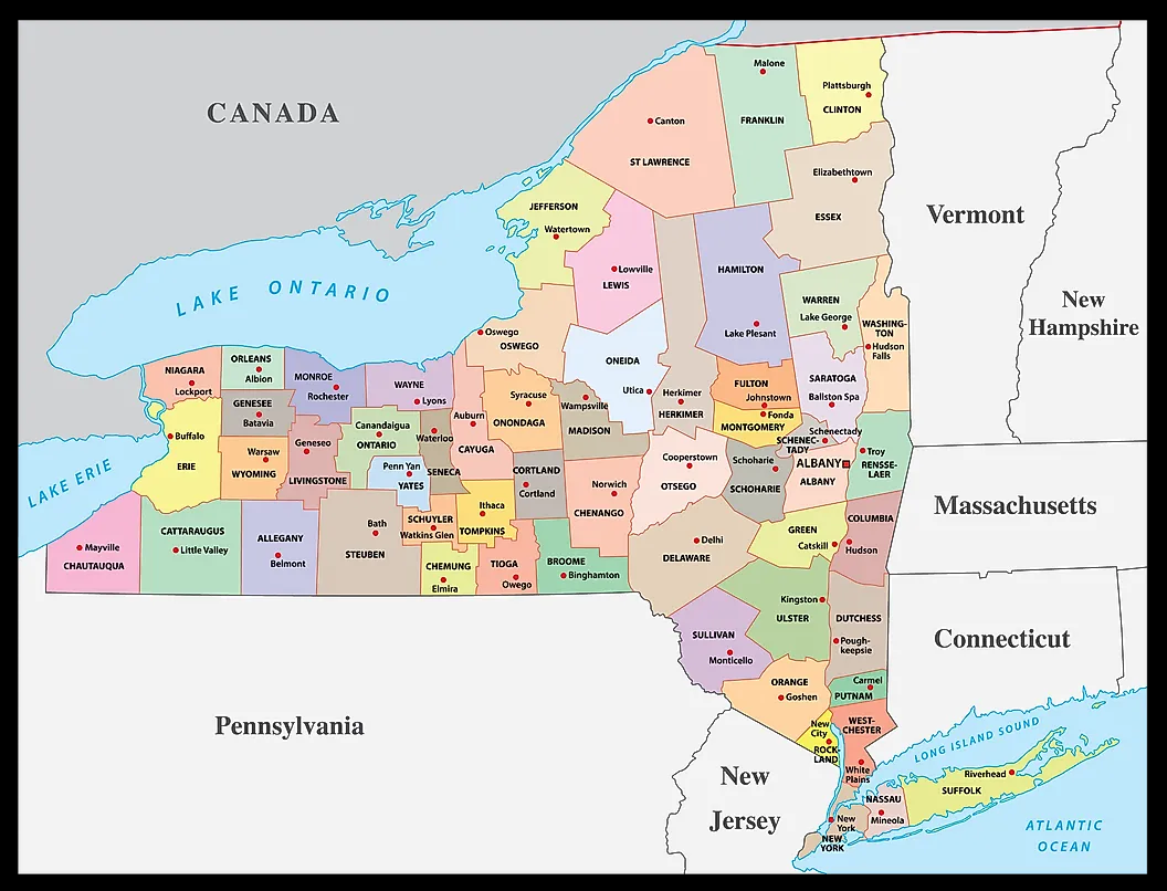
1. New York County Map:
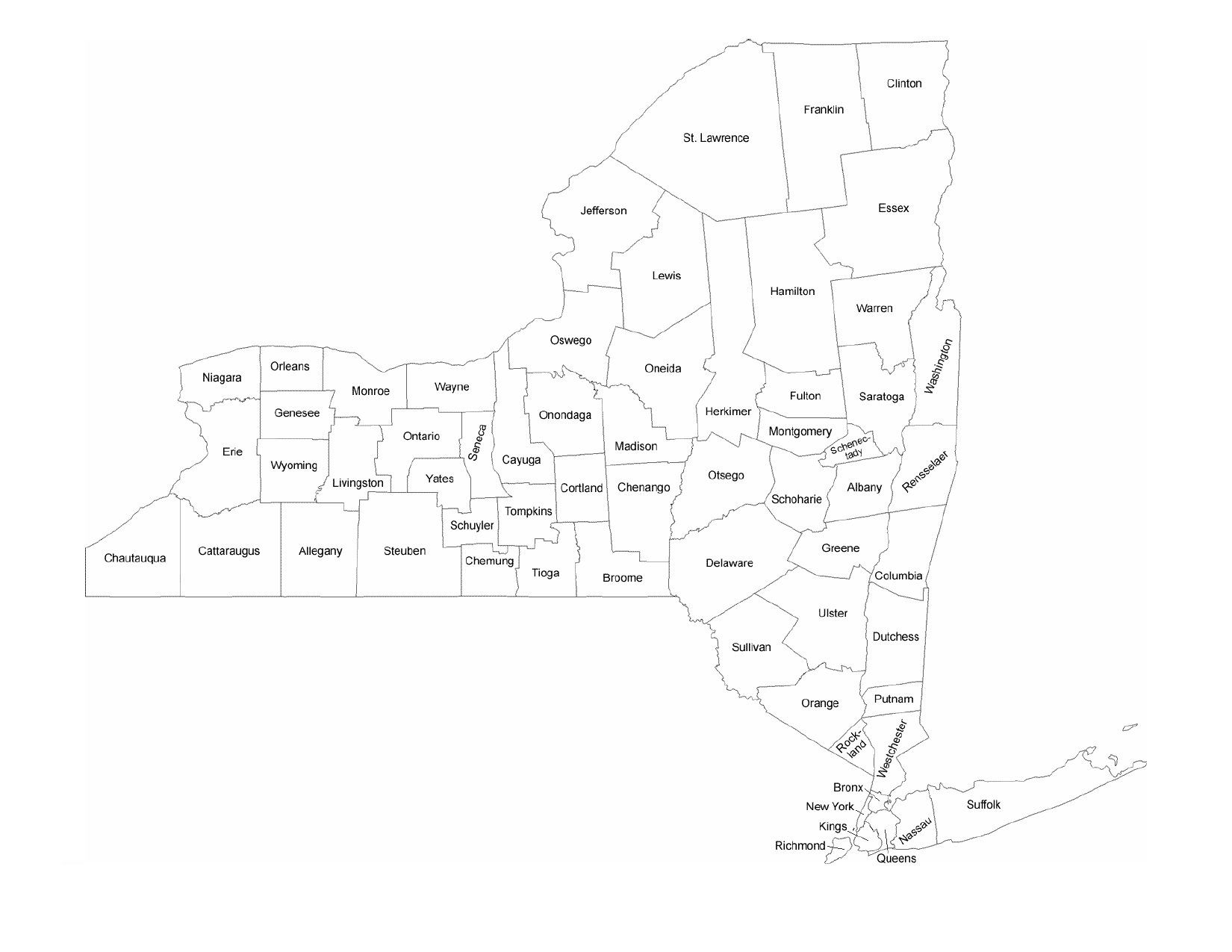
2. NY County Map:
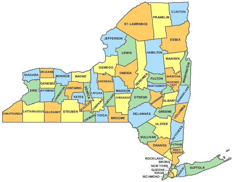
3. Map of New York with counties:
4. New York State Map with Cities:
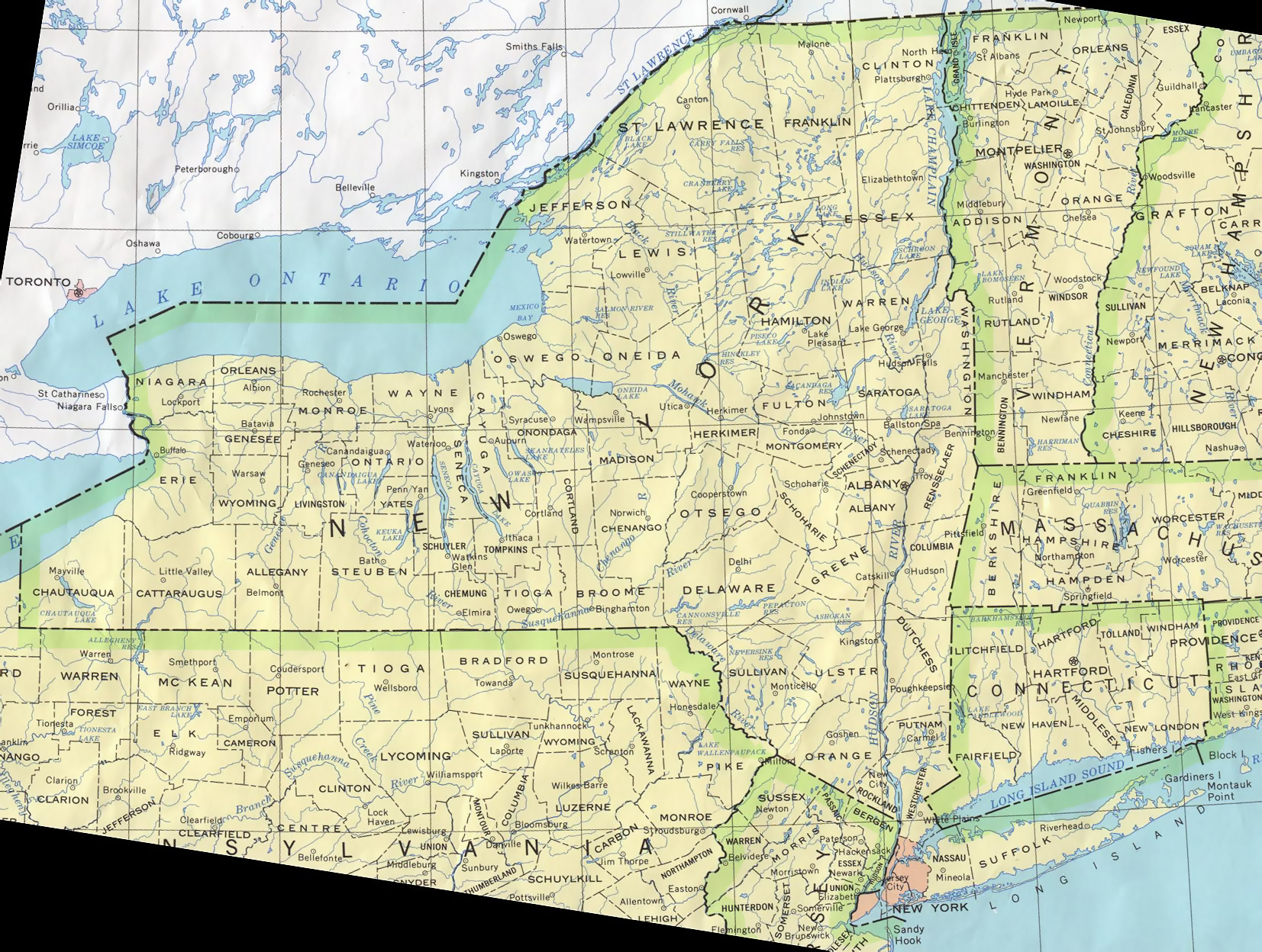
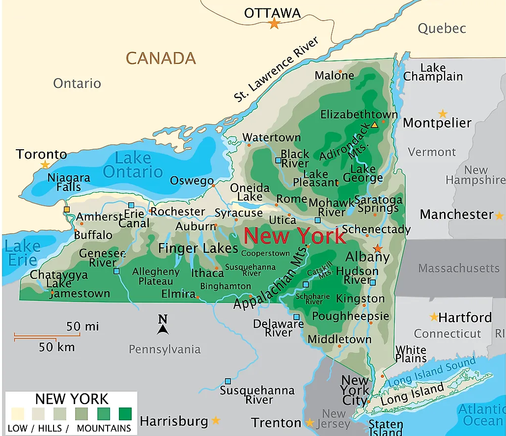
5.Map of New York:
Above we have added a total of five maps of Counties in New York. So, check all these maps and get the correct map you are looking for. And for more detailed information about the Counties, you check the table we are providing below.
List of all Counties that are in the New York:
In this table, you will get useful information such as Name of County, Year of Establishment, approx. population, average area, and the county seat of all counties. And, if you are looking for the maps of any county, please check the first three maps.
| County | County seat | Est. | Population | Area |
| Albany County | Albany | 1683 | 313743 | 533 sq mi |
| Allegany County | Belmont | 1806 | 46106 | 1,034 sq mi |
| Bronx County | none (sui generis) | 1914 | 1424948 | 57.43 sq mi |
| Broome County | Binghamton | 1806 | 197240 | 715 sq mi |
| Cattaraugus County | Little Valley | 1808 | 76426 | 1,310 sq mi |
| Cayuga County | Auburn | 1799 | 75880 | 864 sq mi |
| Chautauqua County | Mayville | 1808 | 126807 | 1,500 sq mi |
| Chemung County | Elmira | 1836 | 83045 | 410.81 sq mi |
| Chenango County | Norwich | 1798 | 46537 | 898.85 sq mi |
| Clinton County | Plattsburgh | 1788 | 79596 | 1,118 sq mi |
| Columbia County | Hudson | 1786 | 61778 | 648 sq mi |
| Cortland County | Cortland | 1808 | 46311 | 502 sq mi |
| Delaware County | Delhi | 1797 | 44378 | 1,468 sq mi |
| Dutchess County | Poughkeepsie | 1683 | 297112 | 825 sq mi |
| Erie County | Buffalo | 1821 | 950683 | 1,227 sq mi |
| Essex County | Elizabethtown | 1799 | 37268 | 1,916 sq mi |
| Franklin County | Malone | 1808 | 47456 | 1,697 sq mi |
| Fulton County | Johnstown | 1838 | 53116 | 533 sq mi |
| Genesee County | Batavia | 1802 | 57853 | 495 sq mi |
| Greene County | Catskill | 1800 | 48499 | 658 sq mi |
| Hamilton County | Lake Pleasant | 1816 | 5119 | 1,808 sq mi |
| Herkimer County | Herkimer | 1791 | 59937 | 1,458 sq mi |
| Jefferson County | Watertown | 1805 | 116295 | 1,857 sq mi |
| Kings County | none (sui generis) | 1683 | 2641052 | 96.9 sq mi |
| Lewis County | Lowville | 1805 | 26573 | 1,290 sq mi |
| Livingston County | Geneseo | 1821 | 61578 | 640 sq mi |
| Madison County | Wampsville | 1806 | 67658 | 662 sq mi |
| Monroe County | Rochester | 1821 | 755160 | 1,366 sq mi |
| Montgomery County | Fonda | 1772 | 49558 | 410 sq mi |
| Nassau County | Mineola | 1899 | 1390907 | 453 sq mi |
| New York County | none (sui generis) | 1683 | 1576876 | 33.77 sq mi |
| Niagara County | Lockport | 1808 | 211653 | 1,140 sq mi |
| Oneida County | Utica | 1798 | 230274 | 1,213 sq mi |
| Onondaga County | Syracuse | 1792 | 473236 | 806 sq mi |
| Ontario County | Canandaigua | 1789 | 112508 | 662 sq mi |
| Orange County | Goshen | 1683 | 404525 | 839 sq mi |
| Orleans County | Albion | 1824 | 40191 | 817 sq mi |
| Oswego County | Oswego | 1816 | 117387 | 1,312 sq mi |
| Otsego County | Cooperstown | 1791 | 58123 | 1,003 sq mi |
| Putnam County | Carmel Hamlet | 1812 | 97936 | 246 sq mi |
| Queens County | none (sui generis) | 1683 | 2331143 | 178.28 sq mi |
| Rensselaer County | Troy | 1791 | 160232 | 665 sq mi |
| Richmond County | none (sui generis) | 1683 | 493494 | 102.5 sq mi |
| Rockland County | New City | 1798 | 339227 | 199 sq mi |
| St. Lawrence County | Canton | 1802 | 108051 | 2,821 sq mi |
| Saratoga County | Ballston Spa | 1791 | 237359 | 844 sq mi |
| Schenectady County | Schenectady | 1809 | 158089 | 210 sq mi |
| Schoharie County | Schoharie | 1795 | 29863 | 626 sq mi |
| Schuyler County | Watkins Glen | 1854 | 17752 | 342 sq mi |
| Seneca County | Waterloo | 1804 | 33688 | 325 sq mi |
| Steuben County | Bath | 1796 | 92948 | 1,404 sq mi |
| Suffolk County | Riverhead | 1683 | 1526344 | 2,373 sq mi |
| Sullivan County | Monticello | 1809 | 79806 | 997 sq mi |
| Tioga County | Owego | 1791 | 47980 | 523 sq mi |
| Tompkins County | Ithaca | 1817 | 105162 | 476 sq mi |
| Ulster County | Kingston | 1683 | 182951 | 1,161 sq mi |
| Warren County | Queensbury | 1813 | 65618 | 870 sq mi |
| Washington County | Fort Edward | 1772 | 60956 | 846 sq mi |
| Wayne County | Lyons | 1823 | 90923 | 1,384 sq mi |
| Westchester County | White Plains | 1683 | 997895 | 500 sq mi |
| Wyoming County | Warsaw | 1841 | 40491 | 596 sq mi |
| Yates County | Penn Yan | 1823 | 24613 | 376 sq mi |
In the first map, you will see the name of all counties and their location on the New York Map. The second map is a simple county map that shows the outline of all counties. This type of map is also known as a blank map or outline map. Now, the third map is a detailed County map of New York. This map shows counties along with all major cities, county seats, and towns. So, you can get this map if you have any work related to the Counties of this state.
The fourth map is a detailed and large map of New York’s Cities and Towns. This is a complete and printable map showing all cities, roads, state highways, and their routes. With the help of this map, you can easily move anywhere in any city in this state. The last map is a simple state map of New York. This map only shows all counties, cities, mountains, hills, rivers, and lakes. So, these were some printable maps related to New York (NY) counties and towns that we have added above. These high-quality maps are available in PDF and JPG formats. You can easily download any map by clicking on the buttons under the preview image. All these maps are free to download.