Kentucky state is divided into 120 counties that included cities, villages, and towns. Her, on this page we are providing some useful information along with printable maps of these counties. If you are here to learn about the counties and cities of Kentucky, USA then you are on the right page. So, please scroll down the page and have a look at our amazing collection of maps. Now. let’s start with a high-quality county map of Kentucky.
Kentucky (KY) County Maps Collection:
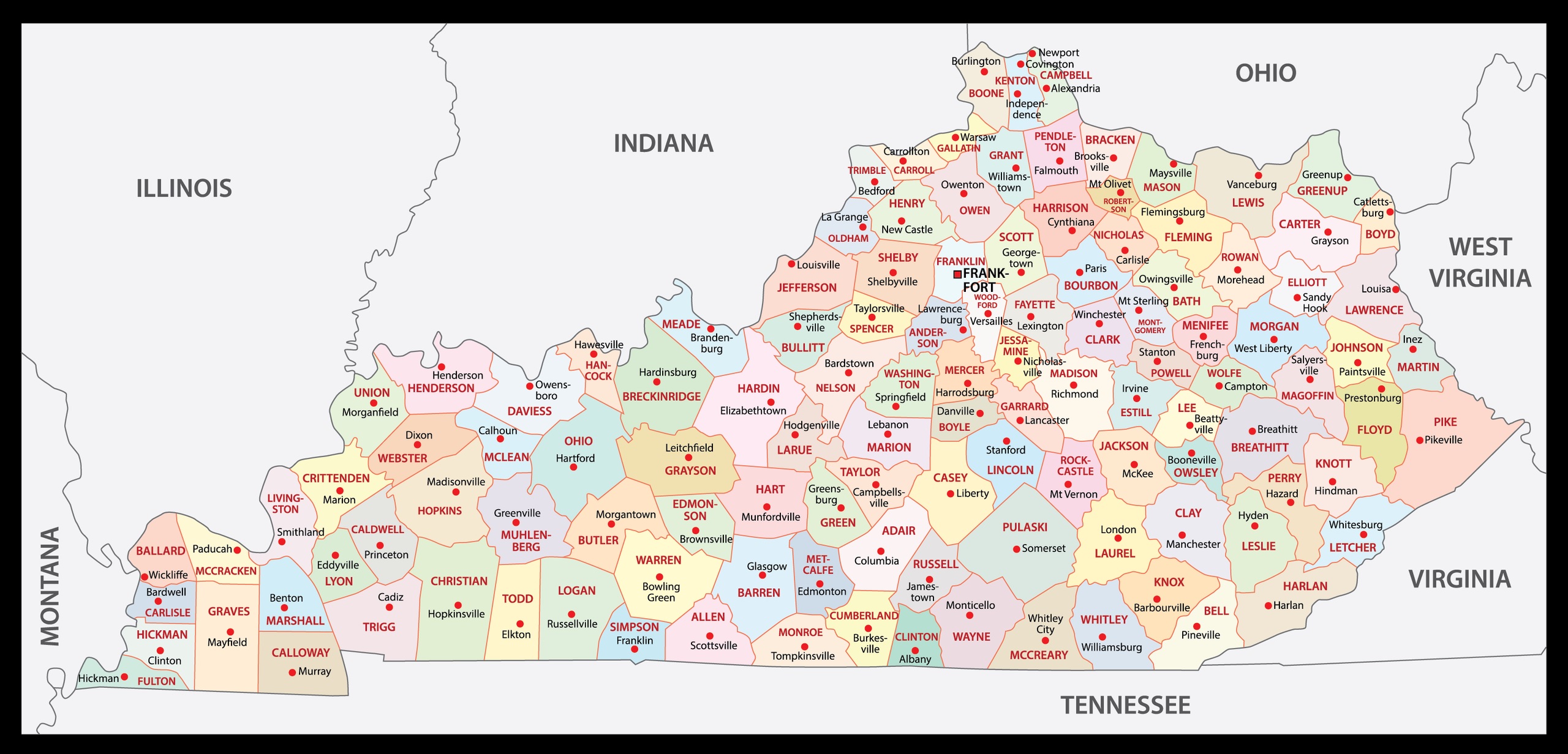
1. County Map of Kentucky:
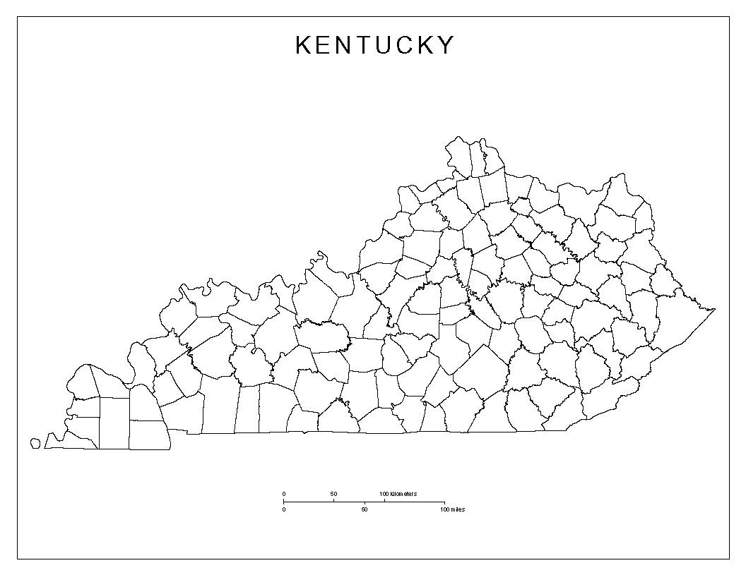
2. Blank County Map of Kentucky:
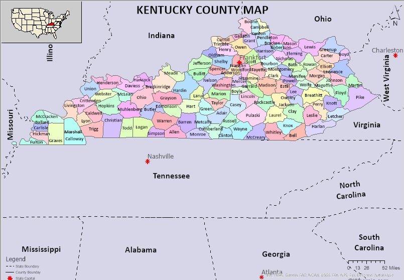
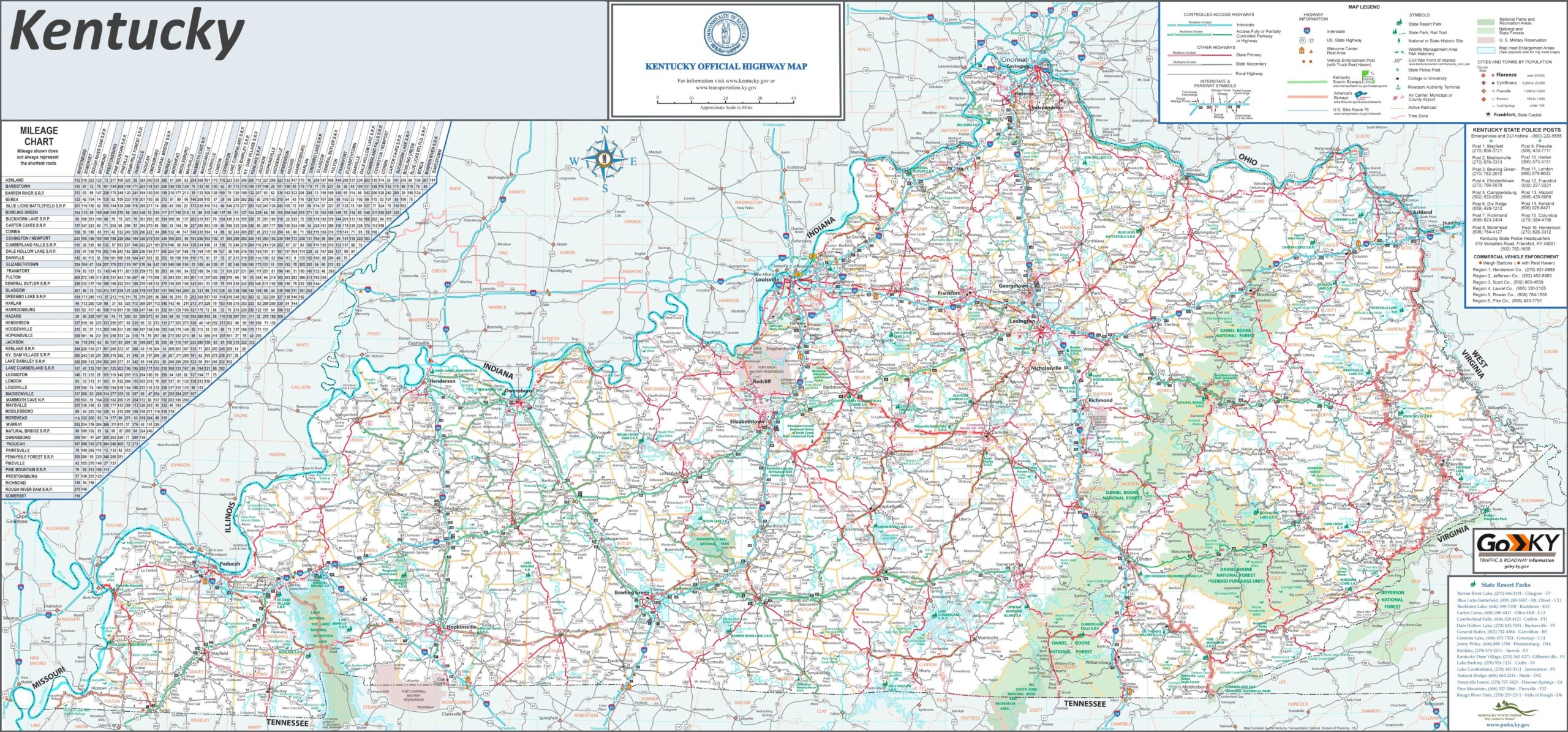
3. KY County Map:
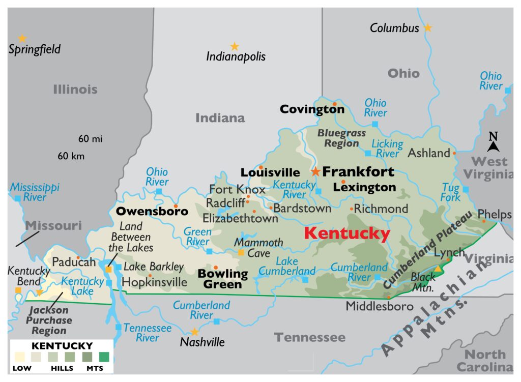
4. Kentucky Map:
5. Map of Kentucky with Cities:
This is the collection of some KY county map that we have added above. We have added a total of five different maps that contain some helpful information about the counties and cities of KY, USA. Here, we are adding some brief information about each map. So, please read the full description before downloading any map from the above collection.
The first map is the main county map of Kentucky, which shows only county names. And the next map is also a map of KY counties but it is visually different. This is a blank and outlined county map of Kentucky state. Below we are also adding a table that shows some useful information about the counties of this state. Please check the table for useful and additional information.
Counties in Kentucky, USA:
This is a list of all counties of Kentucky with some useful information like the name of the county, the county seat, the year in which a county was formed, and the total area covered by these counties.
| S.N | County | County Seat | Population | Area | Formed |
| 1 | Adair County | Columbia | 19204 | 407 sq mi | 1802 |
| 2 | Allen County | Scottsville | 20384 | 346 sq mi | 1815 |
| 3 | Anderson County | Lawrenceburg | 21888 | 203 sq mi | 1827 |
| 4 | Ballard County | Wickliffe | 8240 | 251 sq mi | 1842 |
| 5 | Barren County | Glasgow | 43148 | 491 sq mi | 1798 |
| 6 | Bath County | Owingsville | 12206 | 279 sq mi | 1811 |
| 7 | Bell County | Pineville | 27778 | 361 sq mi | 1867 |
| 8 | Boone County | Burlington | 126413 | 246 sq mi | 1798 |
| 9 | Bourbon County | Paris | 19972 | 291 sq mi | 1785 |
| 10 | Boyd County | Catlettsburg | 48832 | 160 sq mi | 1860 |
| 11 | Boyle County | Danville | 29706 | 182 sq mi | 1842 |
| 12 | Bracken County | Brooksville | 8406 | 203 sq mi | 1796 |
| 13 | Breathitt County | Jackson | 13409 | 495 sq mi | 1839 |
| 14 | Breckinridge County | Hardinsburg | 19888 | 572 sq mi | 1799 |
| 15 | Bullitt County | Shepherdsville | 77955 | 299 sq mi | 1796 |
| 16 | Butler County | Morgantown | 12875 | 428 sq mi | 1810 |
| 17 | Caldwell County | Princeton | 12725 | 347 sq mi | 1809 |
| 18 | Calloway County | Murray | 38282 | 386 sq mi | 1822 |
| 19 | Campbell County | Alexandria | 91833 | 152 sq mi | 1794 |
| 20 | Carlisle County | Bardwell | 4978 | 192 sq mi | 1886 |
| 21 | Carroll County | Carrollton | 10815 | 130 sq mi | 1838 |
| 22 | Carter County | Grayson | 27223 | 411 sq mi | 1838 |
| 23 | Casey County | Liberty | 15891 | 446 sq mi | 1806 |
| 24 | Christian County | Hopkinsville | 74250 | 721 sq mi | 1796 |
| 25 | Clark County | Winchester | 35758 | 254 sq mi | 1792 |
| 26 | Clay County | Manchester | 21147 | 471 sq mi | 1807 |
| 27 | Clinton County | Albany | 10165 | 198 sq mi | 1835 |
| 28 | Crittenden County | Marion | 9224 | 362 sq mi | 1842 |
| 29 | Cumberland County | Burkesville | 6745 | 306 sq mi | 1798 |
| 30 | Daviess County | Owensboro | 98275 | 462 sq mi | 1815 |
| 31 | Edmonson County | Brownsville | 12013 | 303 sq mi | 1825 |
| 32 | Elliott County | Sandy Hook | 7672 | 234 sq mi | 1869 |
| 33 | Estill County | Irvine | 14447 | 254 sq mi | 1808 |
| 34 | Fayette County | Lexington | 310797 | 284 sq mi | 1780 |
| 35 | Fleming County | Flemingsburg | 14545 | 351 sq mi | 1798 |
| 36 | Floyd County | Prestonsburg | 38108 | 394 sq mi | 1800 |
| 37 | Franklin County | Frankfort | 49880 | 210 sq mi | 1794 |
| 38 | Fulton County | Hickman | 6265 | 209 sq mi | 1845 |
| 39 | Gallatin County | Warsaw | 8589 | 99 sq mi | 1798 |
| 40 | Garrard County | Lancaster | 16858 | 231 sq mi | 1796 |
| 41 | Grant County | Williamstown | 24875 | 260 sq mi | 1820 |
| 42 | Graves County | Mayfield | 37618 | 556 sq mi | 1824 |
| 43 | Grayson County | Leitchfield | 26194 | 504 sq mi | 1810 |
| 44 | Green County | Greensburg | 11043 | 289 sq mi | 1792 |
| 45 | Greenup County | Greenup | 36308 | 346 sq mi | 1803 |
| 46 | Hancock County | Hawesville | 8753 | 189 sq mi | 1829 |
| 47 | Hardin County | Elizabethtown | 108266 | 628 sq mi | 1792 |
| 48 | Harlan County | Harlan | 28163 | 467 sq mi | 1819 |
| 49 | Harrison County | Cynthiana | 18592 | 310 sq mi | 1793 |
| 50 | Hart County | Munfordville | 18597 | 416 sq mi | 1819 |
| 51 | Henderson County | Henderson | 46467 | 440 sq mi | 1798 |
| 52 | Henry County | New Castle | 15572 | 289 sq mi | 1798 |
| 53 | Hickman County | Clinton | 4734 | 244 sq mi | 1821 |
| 54 | Hopkins County | Madisonville | 46376 | 551 sq mi | 1806 |
| 55 | Jackson County | McKee | 13289 | 346 sq mi | 1858 |
| 56 | Jefferson County | Louisville | 760026 | 385 sq mi | 1780 |
| 57 | Jessamine County | Nicholasville | 50815 | 173 sq mi | 1798 |
| 58 | Johnson County | Paintsville | 23262 | 262 sq mi | 1843 |
| 59 | Kenton County | Covington and Independence | 163929 | 163 sq mi | 1840 |
| 60 | Knott County | Hindman | 15892 | 352 sq mi | 1884 |
| 61 | Knox County | Barbourville | 31798 | 388 sq mi | 1799 |
| 62 | LaRue County | Hodgenville | 14180 | 263 sq mi | 1843 |
| 63 | Laurel County | London | 60015 | 436 sq mi | 1825 |
| 64 | Lawrence County | Louisa | 15804 | 419 sq mi | 1821 |
| 65 | Lee County | Beattyville | 7594 | 210 sq mi | 1870 |
| 66 | Leslie County | Hyden | 10918 | 404 sq mi | 1878 |
| 67 | Letcher County | Whitesburg | 23359 | 339 sq mi | 1842 |
| 68 | Lewis County | Vanceburg | 13880 | 484 sq mi | 1806 |
| 69 | Lincoln County | Stanford | 24445 | 337 sq mi | 1780 |
| 70 | Livingston County | Smithland | 9359 | 316 sq mi | 1799 |
| 71 | Logan County | Russellville | 26867 | 556 sq mi | 1792 |
| 72 | Lyon County | Eddyville | 8430 | 216 sq mi | 1854 |
| 73 | Madison County | Richmond | 87340 | 441 sq mi | 1785 |
| 74 | Magoffin County | Salyersville | 12913 | 310 sq mi | 1860 |
| 75 | Marion County | Lebanon | 20007 | 347 sq mi | 1834 |
| 76 | Marshall County | Benton | 30953 | 305 sq mi | 1842 |
| 77 | Martin County | Inez | 12537 | 231 sq mi | 1870 |
| 78 | Mason County | Maysville | 17166 | 241 sq mi | 1788 |
| 79 | McCracken County | Paducah | 65316 | 251 sq mi | 1825 |
| 80 | McCreary County | Whitley City | 17863 | 428 sq mi | 1912 |
| 81 | McLean County | Calhoun | 9478 | 254 sq mi | 1854 |
| 82 | Meade County | Brandenburg | 29139 | 308 sq mi | 1823 |
| 83 | Menifee County | Frenchburg | 6287 | 204 sq mi | 1869 |
| 84 | Mercer County | Harrodsburg | 21319 | 251 sq mi | 1785 |
| 85 | Metcalfe County | Edmonton | 9990 | 291 sq mi | 1860 |
| 86 | Monroe County | Tompkinsville | 10704 | 331 sq mi | 1820 |
| 87 | Montgomery County | Mount Sterling | 27474 | 199 sq mi | 1796 |
| 88 | Morgan County | West Liberty | 13303 | 381 sq mi | 1822 |
| 89 | Muhlenberg County | Greenville | 31207 | 475 sq mi | 1798 |
| 90 | Nelson County | Bardstown | 44812 | 423 sq mi | 1784 |
| 91 | Nicholas County | Carlisle | 7041 | 197 sq mi | 1799 |
| 92 | Ohio County | Hartford | 23977 | 594 sq mi | 1798 |
| 93 | Oldham County | La Grange | 63490 | 189 sq mi | 1823 |
| 94 | Owen County | Owenton | 10645 | 352 sq mi | 1819 |
| 95 | Owsley County | Booneville | 4508 | 198 sq mi | 1843 |
| 96 | Pendleton County | Falmouth | 14493 | 280 sq mi | 1798 |
| 97 | Perry County | Hazard | 27597 | 342 sq mi | 1820 |
| 98 | Pike County | Pikeville | 63034 | 788 sq mi | 1821 |
| 99 | Powell County | Stanton | 12434 | 180 sq mi | 1852 |
| 100 | Pulaski County | Somerset | 63825 | 662 sq mi | 1798 |
| 101 | Robertson County | Mount Olivet | 2197 | 100 sq mi | 1867 |
| 102 | Rockcastle County | Mount Vernon | 16826 | 318 sq mi | 1810 |
| 103 | Rowan County | Morehead | 23655 | 281 sq mi | 1856 |
| 104 | Russell County | Jamestown | 17774 | 254 sq mi | 1825 |
| 105 | Scott County | Georgetown | 51284 | 285 sq mi | 1792 |
| 106 | Shelby County | Shelbyville | 44875 | 384 sq mi | 1792 |
| 107 | Simpson County | Franklin | 17826 | 236 sq mi | 1819 |
| 108 | Spencer County | Taylorsville | 17668 | 186 sq mi | 1824 |
| 109 | Taylor County | Campbellsville | 25257 | 270 sq mi | 1848 |
| 110 | Todd County | Elkton | 12520 | 376 sq mi | 1819 |
| 111 | Trigg County | Cadiz | 14142 | 443 sq mi | 1820 |
| 112 | Trimble County | Bedford | 8786 | 149 sq mi | 1837 |
| 113 | Union County | Morganfield | 15165 | 345 sq mi | 1811 |
| 114 | Warren County | Bowling Green | 120460 | 545 sq mi | 1796 |
| 115 | Washington County | Springfield | 11959 | 301 sq mi | 1792 |
| 116 | Wayne County | Monticello | 20486 | 459 sq mi | 1800 |
| 117 | Webster County | Dixon | 13236 | 335 sq mi | 1860 |
| 118 | Whitley County | Williamsburg | 35503 | 440 sq mi | 1818 |
| 119 | Wolfe County | Campton | 7214 | 223 sq mi | 1860 |
| 120 | Woodford County | Versailles | 25563 | 191 sq mi | 1788 |
And the fourth map is a detailed map of Kentucky. All major cities and towns are visible on this map with all major roads. And major lakes and rivers are also shown on this map. The fifth map is a cities and towns map of Kentucky that shows all counties, major cities, city roads, and interstate highways. So, these were some printable maps that we have added above. These large maps are available in PDF and JPG (Image) formats. You can easily download any map by clicking on the buttons under the preview image. All these maps are free to download.