Washington is a state in United States of America which is divided into 39 counties. This state is situated in the pacific northwest area of the country. If you are looking for some right information and free maps related to counties then you are on the right page. Below we are listing all counties along with some free and interactive county maps related to Washington, USA. You can start with a WA County map. You can also check our main article which is Printable Washington State Maps.
Collections of Washington County Maps:
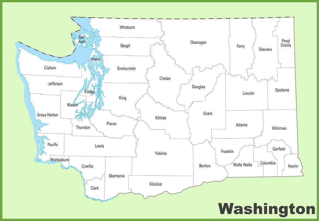
1. Washington County Map:

2. County Map of Washington:
3. WA County Map:

4. Map of Washington with Counties:

5. Washington Map:

6. Detalied Cities and Town Map of Washington:

Here, we have added six maps in which first four maps are related to the counties of Washington. Each map contains some useful information. For you, we are also adding some more useful information about each county. So, read the description and save any map for any work or purpose. We are also adding a table that shows some information about the counties of this state.
List of all Counties in the Washington State:
With the help of this table, you will get some quick information about the counties. And for some additional information, you can check the first map which is a county map of Washington.
| County Name | County Seat | Established | Population | Total Area |
| Adams County | Ritzville | 1883 | 20613 | 1,925 sq mi |
| Asotin County | Asotin | 1883 | 22285 | 636 sq mi |
| Benton County | Prosser | 1905 | 206873 | 1,700 sq mi |
| Chelan County | Wenatchee | 1899 | 79074 | 2,920 sq mi |
| Clallam County | Port Angeles | 1854 | 77155 | 1,738 sq mi |
| Clark County | Vancouver | 1845 | 503311 | 629 sq mi |
| Columbia County | Dayton | 1875 | 3952 | 869 sq mi |
| Cowlitz County | Kelso | 1854 | 110730 | 1,139 sq mi |
| Douglas County | Waterville | 1883 | 42938 | 1,819 sq mi |
| Ferry County | Republic | 1899 | 7178 | 2,204 sq mi |
| Franklin County | Pasco | 1883 | 96749 | 1,242 sq mi |
| Garfield County | Pomeroy | 1881 | 2286 | 710 sq mi |
| Grant County | Ephrata | 1909 | 99123 | 2,680 sq mi |
| Grays Harbor County | Montesano | 1854 | 75636 | 1,902 sq mi |
| Island County | Coupeville | 1852 | 86857 | 209 sq mi |
| Jefferson County | Port Townsend | 1852 | 32977 | 1,804 sq mi |
| King County | Seattle | 1852 | 2269675 | 2,115 sq mi |
| Kitsap County | Port Orchard | 1857 | 275611 | 395 sq mi |
| Kittitas County | Ellensburg | 1883 | 44337 | 2,297 sq mi |
| Klickitat County | Goldendale | 1859 | 22735 | 1,872 sq mi |
| Lewis County | Chehalis | 1845 | 82149 | 2,403 sq mi |
| Lincoln County | Davenport | 1883 | 10876 | 2,311 sq mi |
| Mason County | Shelton | 1854 | 65726 | 959 sq mi |
| Okanogan County | Okanogan | 1888 | 42104 | 5,268 sq mi |
| Pacific County | South Bend | 1851 | 23365 | 933 sq mi |
| Pend Oreille County | Newport | 1911 | 13401 | 1,400 sq mi |
| Pierce County | Tacoma | 1852 | 921130 | 1,670 sq mi |
| San Juan County | Friday Harbor | 1873 | 17788 | 174 sq mi |
| Skagit County | Mount Vernon | 1883 | 129523 | 1,731 sq mi |
| Skamania County | Stevenson | 1854 | 12036 | 1,656 sq mi |
| Snohomish County | Everett | 1861 | 827957 | 2,087 sq mi |
| Spokane County | Spokane | 1879 | 539339 | 1,764 sq mi |
| Stevens County | Colville | 1863 | 46445 | 2,478 sq mi |
| Thurston County | Olympia | 1852 | 294793 | 722 sq mi |
| Wahkiakum County | Cathlamet | 1854 | 4422 | 264 sq mi |
| Walla Walla County | Walla Walla | 1854 | 62584 | 1,270 sq mi |
| Whatcom County | Bellingham | 1854 | 226847 | 2,107 sq mi |
| Whitman County | Colfax | 1871 | 47973 | 2,159 sq mi |
| Yakima County | Yakima | 1865 | 256728 | 4,296 sq mi |
In the first map, you will see the name of all counties and their location on the Washington Map. It is the main county map of Washington state. Now, the second map is a detailed WA county map. This map shows counties along with all major cities and towns. So, you can get this map if you have any work related to the Counties of this state. The third map is also showing all counties, but it is visually different. Now, the fourth map is also same as all last three maps, but it is also different in visuals. So, do not get confused in first four maps.
The fifth map is a simple state map of Washington. This map only shows all counties, towns, cities, mountains, rivers, and lakes. The sixth map is a detailed and large map of Washington’s Cities and Towns. It is a complete and printable map showing all cities, roads, interstate highways, and their routes. With the help of this map, you can easily move anywhere in any city in Washington. So, these were some printable maps related to Washington county and towns that we have added above. These high-quality maps are available in PDF and JPG formats. You can easily download any map by clicking on the buttons under the preview image. All these maps are free to download.