Tennessee is a state in the USA, that is divided into 95 counties. Among all counties, Washington county is the first county which is established in 1777. And, based on population Shelby County has the highest population of 924,454 and the Pickett County has a population of 5,079. So, if you are interested to learn more about the all counties of Tennessee then you should stay on this page and read the full article because here on this page we are providing some useful information related to all counties in TN, USA. And, in addition, we are also including some printable maps related to Tennessee’s counties.
So, scroll down the page and let’s start with a map of Tennessee counties and cities. Please have a look at our collection.
Tennessee (TN) County Maps Collection:
1. County Map of Tennessee:

2. TN County Map:

3. Tennessee County Map:
4. Map of Tennessee:
5. Tennessee Map with Cities and Towns:
Above we have added five different maps. So, check all these maps and get the correct map you are looking for. And for more detailed information about the Counties, you check the table we are providing below.
List of all Counties that are in Tennessee:
In this table, you will get useful information such as Name of County, Year of Establishment, approx. population, average area, and their county seat of all counties. And, if you are looking for the maps and location of any county, please check the first three maps.
| County | County Seat | Established | Population | Area |
| Washington County | Jonesborough | 1777 | 134236 | 326 sq mi |
| Sullivan County | Blountville | 1779 | 159265 | 413 sq mi |
| Davidson County | Nashville | 1783 | 703953 | 502 sq mi |
| Greene County | Greeneville | 1783 | 70621 | 622 sq mi |
| Hawkins County | Rogersville | 1786 | 57288 | 487 sq mi |
| Sumner County | Gallatin | 1786 | 200557 | 529 sq mi |
| Jefferson County | Dandridge | 1792 | 55624 | 274 sq mi |
| Knox County | Knoxville | 1792 | 486677 | 509 sq mi |
| Sevier County | Sevierville | 1794 | 99517 | 592 sq mi |
| Blount County | Maryville | 1795 | 137605 | 559 sq mi |
| Carter County | Elizabethton | 1796 | 56134 | 341 sq mi |
| Grainger County | Rutledge | 1796 | 23763 | 280 sq mi |
| Montgomery County | Clarksville | 1796 | 227900 | 539 sq mi |
| Robertson County | Springfield | 1796 | 74098 | 477 sq mi |
| Cocke County | Newport | 1797 | 36418 | 434 sq mi |
| Smith County | Carthage | 1799 | 20172 | 314 sq mi |
| Williamson County | Franklin | 1799 | 255735 | 582 sq mi |
| Wilson County | Lebanon | 1799 | 151917 | 571 sq mi |
| Anderson County | Clinton | 1801 | 77576 | 338 sq mi |
| Claiborne County | Tazewell | 1801 | 32267 | 434 sq mi |
| Jackson County | Gainesboro | 1801 | 11750 | 309 sq mi |
| Roane County | Kingston | 1801 | 53992 | 361 sq mi |
| Dickson County | Charlotte | 1803 | 55292 | 490 sq mi |
| Rutherford County | Murfreesboro | 1803 | 352182 | 619 sq mi |
| Stewart County | Dover | 1803 | 13855 | 458 sq mi |
| Campbell County | Jacksboro | 1806 | 39578 | 480 sq mi |
| Overton County | Livingston | 1806 | 22839 | 433 sq mi |
| White County | Sparta | 1806 | 27650 | 377 sq mi |
| Bedford County | Shelbyville | 1807 | 51119 | 474 sq mi |
| Bledsoe County | Pikeville | 1807 | 15234 | 406 sq mi |
| Franklin County | Winchester | 1807 | 43215 | 553 sq mi |
| Hickman County | Centerville | 1807 | 25307 | 613 sq mi |
| Maury County | Columbia | 1807 | 104760 | 613 sq mi |
| Rhea County | Dayton | 1807 | 33136 | 316 sq mi |
| Warren County | McMinnville | 1807 | 41523 | 433 sq mi |
| Giles County | Pulaski | 1809 | 30542 | 611 sq mi |
| Humphreys County | Waverly | 1809 | 19211 | 532 sq mi |
| Lincoln County | Fayetteville | 1809 | 35433 | 570 sq mi |
| Lawrence County | Lawrenceburg | 1817 | 44828 | 617 sq mi |
| Marion County | Jasper | 1817 | 28877 | 500 sq mi |
| Morgan County | Wartburg | 1817 | 21254 | 522 sq mi |
| Wayne County | Waynesboro | 1817 | 16409 | 734 sq mi |
| Hamilton County | Chattanooga | 1819 | 369135 | 543 sq mi |
| Hardin County | Savannah | 1819 | 26892 | 578 sq mi |
| McMinn County | Athens | 1819 | 54059 | 430 sq mi |
| Monroe County | Madisonville | 1819 | 46698 | 635 sq mi |
| Perry County | Linden | 1819 | 8472 | 415 sq mi |
| Shelby County | Memphis | 1819 | 924454 | 755 sq mi |
| Carroll County | Huntingdon | 1821 | 28432 | 599 sq mi |
| Henderson County | Lexington | 1821 | 27953 | 520 sq mi |
| Henry County | Paris | 1821 | 32239 | 562 sq mi |
| Madison County | Jackson | 1821 | 98775 | 557 sq mi |
| Dyer County | Dyersburg | 1823 | 36615 | 510 sq mi |
| Fentress County | Jamestown | 1823 | 18850 | 499 sq mi |
| Gibson County | Trenton | 1823 | 50541 | 603 sq mi |
| Hardeman County | Bolivar | 1823 | 25426 | 668 sq mi |
| Haywood County | Brownsville | 1823 | 17694 | 533 sq mi |
| McNairy County | Selmer | 1823 | 25860 | 560 sq mi |
| Obion County | Union City | 1823 | 30466 | 545 sq mi |
| Tipton County | Covington | 1823 | 61004 | 459 sq mi |
| Weakley County | Dresden | 1823 | 33036 | 580 sq mi |
| Fayette County | Somerville | 1824 | 42832 | 705 sq mi |
| Benton County | Camden | 1835 | 15872 | 394 sq mi |
| Lauderdale County | Ripley | 1835 | 25108 | 470 sq mi |
| Bradley County | Cleveland | 1836 | 110162 | 329 sq mi |
| Cannon County | Woodbury | 1836 | 14553 | 266 sq mi |
| Coffee County | Manchester | 1836 | 59032 | 429 sq mi |
| Johnson County | Mountain City | 1836 | 18170 | 299 sq mi |
| Marshall County | Lewisburg | 1836 | 34984 | 375 sq mi |
| Meigs County | Decatur | 1836 | 13049 | 195 sq mi |
| DeKalb County | Smithville | 1837 | 20478 | 304 sq mi |
| Polk County | Benton | 1839 | 17776 | 435 sq mi |
| Van Buren County | Spencer | 1840 | 6324 | 247 sq mi |
| Macon County | Lafayette | 1842 | 25699 | 307 sq mi |
| Lewis County | Hohenwald | 1843 | 12857 | 282 sq mi |
| Grundy County | Altamont | 1844 | 13622 | 361 sq mi |
| Hancock County | Sneedville | 1844 | 6787 | 222 sq mi |
| Decatur County | Decaturville | 1845 | 11391 | 333 sq mi |
| Scott County | Huntsville | 1849 | 21917 | 532 sq mi |
| Union County | Maynardville | 1850 | 20040 | 224 sq mi |
| Putnam County | Cookeville | 1854 | 81118 | 401 sq mi |
| Cumberland County | Crossville | 1855 | 62451 | 682 sq mi |
| Cheatham County | Ashland City | 1856 | 41523 | 303 sq mi |
| Sequatchie County | Dunlap | 1857 | 16396 | 266 sq mi |
| Clay County | Celina | 1870 | 7555 | 236 sq mi |
| Hamblen County | Morristown | 1870 | 64468 | 161 sq mi |
| Lake County | Tiptonville | 1870 | 7128 | 163 sq mi |
| Loudon County | Loudon | 1870 | 56690 | 229 sq mi |
| Trousdale County | Hartsville | 1870 | 12035 | 114 sq mi |
| Crockett County | Alamo | 1871 | 13979 | 265 sq mi |
| Houston County | Erin | 1871 | 8317 | 200 sq mi |
| Moore County | Lynchburg | 1871 | 6644 | 129 sq mi |
| Unicoi County | Erwin | 1875 | 17698 | 186 sq mi |
| Chester County | Henderson | 1879 | 17504 | 289 sq mi |
| Pickett County | Byrdstown | 1879 | 5079 | 163 sq mi |
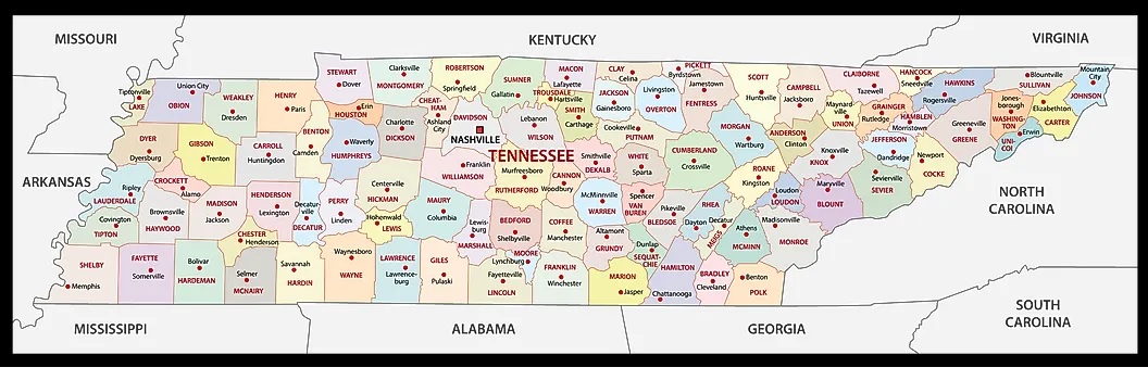
The first map shows only all counties and their county seats. So, if you are looking for such types of information, then this map will help you. And this is a simple county map of Tennessee. The next is a county map with cities and towns. This map shows all counties with some cities and towns in Tennessee. So, check the first two maps if you are looking for a detailed version of the county map. And, the third map is a map of counties with county seats.
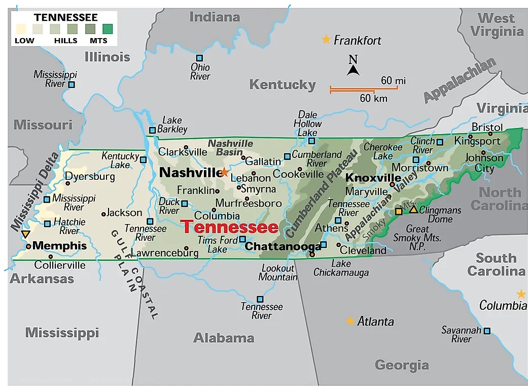
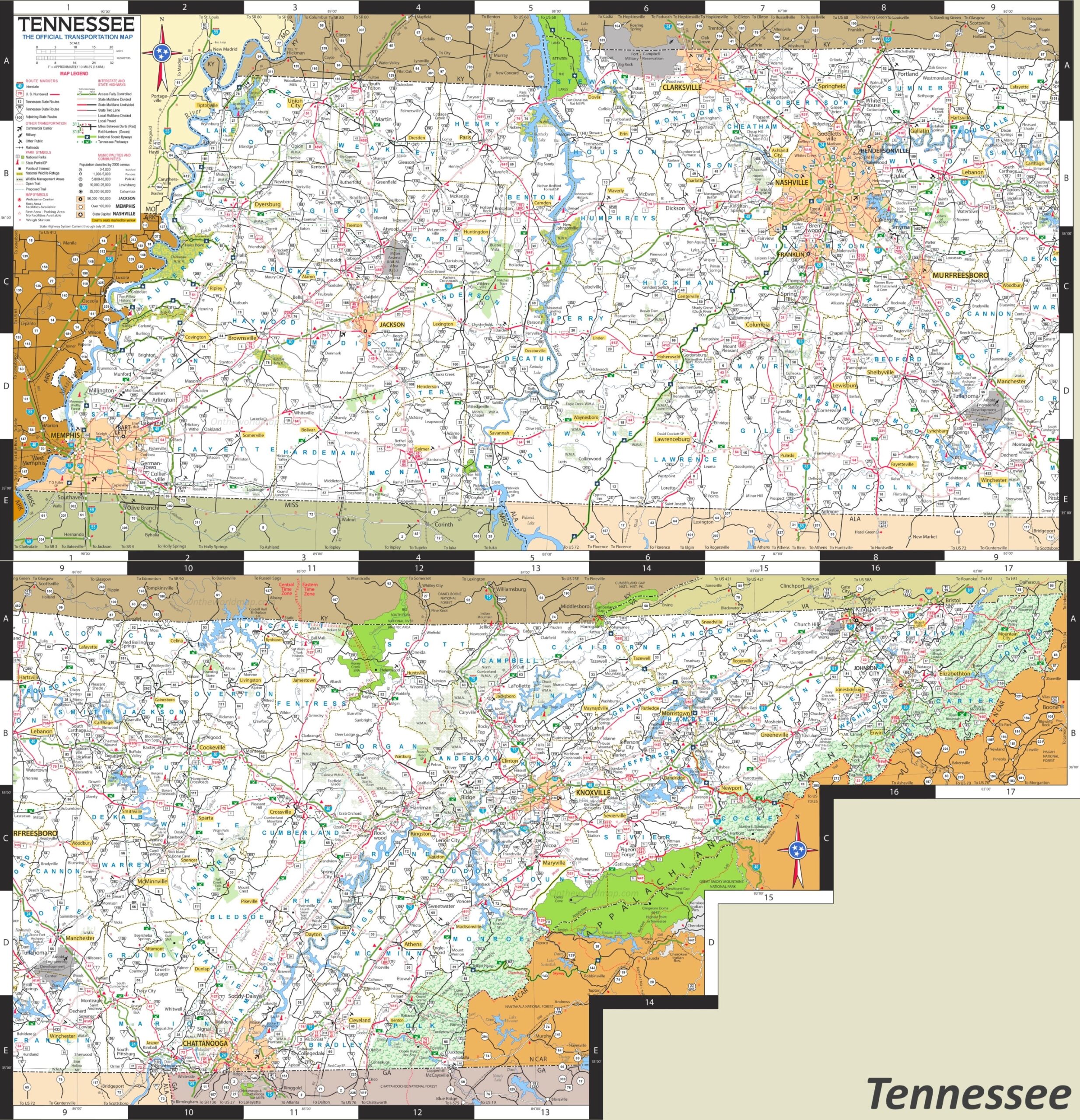
The last two maps are related to the main state and city map of Tennessee. The fourth map is an overview map of this state. On this map, all counties are visible, with some major cities, rivers, lakes, and mountains. In the last map, you will locate any city and town quickly. And you can also navigate anywhere in any city of this state with the help of this map because this map also shows all street roads and interstate highways.
So, these were some printable collections of TN county maps with cities and towns. You can quickly get these high-quality maps on your device by clicking on the preview button under the map. We have provided each map in two types of formats, PDF and JPG (Image) format. So, you can save or view any map for free.