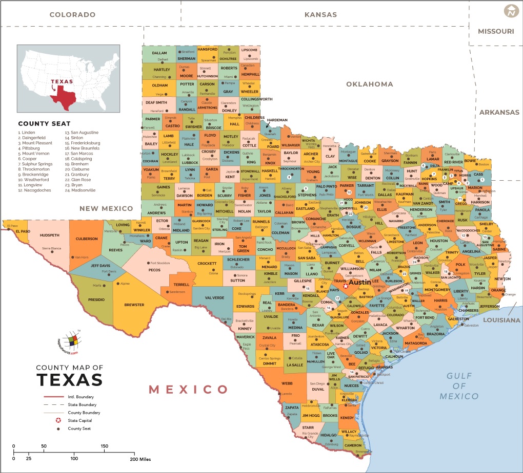
Texas has divided into counties 254 counties. Brewster is the largest county based on the area that covers an area of 16040 km2 and Harris County is the most populated county in Texas with 4,728,030 inhabitants. On this page, we are providing useful information about all counties along with some printable maps. Below, we have added a high-quality county map of Texas, a city map, and a state map. Scroll down the page, and check our collection of maps.
Texas (TX) County Maps Collection:
1. County Map of Texas:

2. County Map of Texas with Cities:
3. Blank County Map of Texas:
4. Map of Texas with Cities & Towns:
5. Map of Texas:

This is the collection of some high-quality TX county map that we have added above. We have added a total of five different maps that contain some helpful information about the counties and cities of Texas, USA. Here, we are adding some brief information about each map. So, please read the full description before downloading any map from the above collection.
The first map is a main county map of Texas, which shows only county names. And the next map is also a map of Texas with counties but it is visually different. The third map is the Texas county map with major cities and towns. Below we are adding a list of Texas Counties in alphabetical order. This table shows some important info about all counties. You can check the maps section if you are looking for county maps.
| S.N | County | County Seat | Population | Area | Formed |
| 1 | Anderson County | Palestine | 58458 | 1,071 sq mi | 1846 |
| 2 | Andrews County | Andrews | 14786 | 1,501 sq mi | 1876 |
| 3 | Angelina County | Lufkin | 86771 | 802 sq mi | 1846 |
| 4 | Aransas County | Rockport | 23158 | 252 sq mi | 1871 |
| 5 | Archer County | Archer City | 9054 | 910 sq mi | 1858 |
| 6 | Armstrong County | Claude | 1901 | 914 sq mi | 1876 |
| 7 | Atascosa County | Jourdanton | 44911 | 1,232 sq mi | 1856 |
| 8 | Austin County | Bellville | 28417 | 653 sq mi | 1836 |
| 9 | Bailey County | Muleshoe | 7165 | 827 sq mi | 1876 |
| 10 | Bandera County | Bandera | 20485 | 792 sq mi | 1856 |
| 11 | Bastrop County | Bastrop | 74171 | 888 sq mi | 1836 |
| 12 | Baylor County | Seymour | 3726 | 871 sq mi | 1858 |
| 13 | Bee County | Beeville | 31861 | 880 sq mi | 1857 |
| 14 | Bell County | Belton | 310235 | 1,059 sq mi | 1850 |
| 15 | Bexar County | San Antonio | 1714773 | 1,247 sq mi | 1836 |
| 16 | Blanco County | Johnson City | 10497 | 711 sq mi | 1858 |
| 17 | Borden County | Gail | 641 | 899 sq mi | 1876 |
| 18 | Bosque County | Meridian | 18212 | 989 sq mi | 1854 |
| 19 | Bowie County | Boston | 92565 | 888 sq mi | 1840 |
| 20 | Brazoria County | Angleton | 313166 | 1,387 sq mi | 1836 |
| 21 | Brazos County | Bryan | 194851 | 586 sq mi | 1841 |
| 22 | Brewster County | Alpine | 9232 | 6,193 sq mi | 1887 |
| 23 | Briscoe County | Silverton | 1637 | 900 sq mi | 1876 |
| 24 | Brooks County | Falfurrias | 7223 | 943 sq mi | 1911 |
| 25 | Brown County | Brownwood | 38106 | 944 sq mi | 1856 |
| 26 | Burleson County | Caldwell | 17187 | 666 sq mi | 1846 |
| 27 | Burnet County | Burnet | 42750 | 995 sq mi | 1852 |
| 28 | Caldwell County | Lockhart | 38066 | 546 sq mi | 1848 |
| 29 | Calhoun County | Port Lavaca | 21381 | 512 sq mi | 1846 |
| 30 | Callahan County | Baird | 13544 | 899 sq mi | 1858 |
| 31 | Cameron County | Brownsville | 406220 | 906 sq mi | 1848 |
| 32 | Camp County | Pittsburg | 12401 | 198 sq mi | 1874 |
| 33 | Carson County | Panhandle | 6182 | 923 sq mi | 1876 |
| 34 | Cass County | Linden | 30464 | 938 sq mi | 1846 |
| 35 | Castro County | Dimmitt | 8062 | 898 sq mi | 1876 |
| 36 | Chambers County | Anahuac | 35096 | 599 sq mi | 1858 |
| 37 | Cherokee County | Rusk | 50845 | 1,052 sq mi | 1846 |
| 38 | Childress County | Childress | 7041 | 710 sq mi | 1876 |
| 39 | Clay County | Henrietta | 10752 | 1,098 sq mi | 1857 |
| 40 | Cochran County | Morton | 3127 | 775 sq mi | 1876 |
| 41 | Coke County | Robert Lee | 3320 | 899 sq mi | 1889 |
| 42 | Coleman County | Coleman | 8895 | 1,273 sq mi | 1858 |
| 43 | Collin County | McKinney | 782341 | 848 sq mi | 1846 |
| 44 | Collingsworth County | Wellington | 3057 | 919 sq mi | 1876 |
| 45 | Colorado County | Columbus | 20874 | 963 sq mi | 1836 |
| 46 | Comal County | New Braunfels | 108472 | 562 sq mi | 1846 |
| 47 | Comanche County | Comanche | 13974 | 938 sq mi | 1856 |
| 48 | Concho County | Paint Rock | 4087 | 992 sq mi | 1858 |
| 49 | Cooke County | Gainesville | 38437 | 874 sq mi | 1848 |
| 50 | Coryell County | Gatesville | 75402 | 1,052 sq mi | 1854 |
| 51 | Cottle County | Paducah | 1505 | 901 sq mi | 1876 |
| 52 | Crane County | Crane | 4375 | 786 sq mi | 1887 |
| 53 | Crockett County | Ozona | 3719 | 2,808 sq mi | 1875 |
| 54 | Crosby County | Crosbyton | 6059 | 900 sq mi | 1876 |
| 55 | Culberson County | Van Horn | 2398 | 3,813 sq mi | 1911 |
| 56 | Dallam County | Dalhart | 6703 | 1,505 sq mi | 1876 |
| 57 | Dallas County | Dallas | 2368139 | 880 sq mi | 1846 |
| 58 | Dawson County | Lamesa | 13833 | 902 sq mi | 1876 |
| 59 | Deaf Smith County | Hereford | 19372 | 1,497 sq mi | 1876 |
| 60 | Delta County | Cooper | 5231 | 277 sq mi | 1870 |
| 61 | Denton County | Denton | 662614 | 888 sq mi | 1846 |
| 62 | DeWitt County | Cuero | 20097 | 909 sq mi | 1846 |
| 63 | Dickens County | Dickens | 2444 | 904 sq mi | 1876 |
| 64 | Dimmit County | Carrizo Springs | 9996 | 1,331 sq mi | 1858 |
| 65 | Donley County | Clarendon | 3677 | 930 sq mi | 1876 |
| 66 | Duval County | San Diego | 11782 | 1,793 sq mi | 1858 |
| 67 | Eastland County | Eastland | 18583 | 926 sq mi | 1858 |
| 68 | Ector County | Odessa | 137130 | 901 sq mi | 1887 |
| 69 | Edwards County | Rocksprings | 2002 | 2,120 sq mi | 1858 |
| 70 | El Paso County | El Paso | 800647 | 1,013 sq mi | 1848 |
| 71 | Ellis County | Waxahachie | 149610 | 940 sq mi | 1849 |
| 72 | Erath County | Stephenville | 37890 | 1,086 sq mi | 1856 |
| 73 | Falls County | Marlin | 17866 | 769 sq mi | 1850 |
| 74 | Fannin County | Bonham | 33915 | 892 sq mi | 1837 |
| 75 | Fayette County | La Grange | 24556 | 950 sq mi | 1837 |
| 76 | Fisher County | Roby | 3974 | 901 sq mi | 1876 |
| 77 | Floyd County | Floydada | 6446 | 992 sq mi | 1876 |
| 78 | Foard County | Crowell | 1336 | 707 sq mi | 1891 |
| 79 | Fort Bend County | Richmond | 585375 | 875 sq mi | 1837 |
| 80 | Franklin County | Mount Vernon | 10605 | 286 sq mi | 1875 |
| 81 | Freestone County | Fairfield | 19816 | 885 sq mi | 1850 |
| 82 | Frio County | Pearsall | 17217 | 1,133 sq mi | 1858 |
| 83 | Gaines County | Seminole | 17526 | 1,502 sq mi | 1876 |
| 84 | Galveston County | Galveston | 291309 | 399 sq mi | 1838 |
| 85 | Garza County | Post | 6461 | 896 sq mi | 1876 |
| 86 | Gillespie County | Fredericksburg | 24837 | 1,061 sq mi | 1848 |
| 87 | Glasscock County | Garden City | 1226 | 901 sq mi | 1887 |
| 88 | Goliad County | Goliad | 7210 | 854 sq mi | 1836 |
| 89 | Gonzales County | Gonzales | 19807 | 1,068 sq mi | 1836 |
| 90 | Gray County | Pampa | 22535 | 928 sq mi | 1876 |
| 91 | Grayson County | Sherman | 120877 | 934 sq mi | 1846 |
| 92 | Gregg County | Longview | 121730 | 274 sq mi | 1873 |
| 93 | Grimes County | Anderson | 26604 | 794 sq mi | 1846 |
| 94 | Guadalupe County | Seguin | 131533 | 711 sq mi | 1846 |
| 95 | Hale County | Plainview | 36273 | 1,005 sq mi | 1876 |
| 96 | Hall County | Memphis | 3353 | 903 sq mi | 1876 |
| 97 | Hamilton County | Hamilton | 8517 | 836 sq mi | 1856 |
| 98 | Hansford County | Spearman | 5613 | 920 sq mi | 1876 |
| 99 | Hardeman County | Quanah | 4139 | 695 sq mi | 1858 |
| 100 | Hardin County | Kountze | 54635 | 894 sq mi | 1858 |
| 101 | Harris County | Houston | 4092459 | 1,729 sq mi | 1836 |
| 102 | Harrison County | Marshall | 65631 | 899 sq mi | 1839 |
| 103 | Hartley County | Channing | 6062 | 1,462 sq mi | 1876 |
| 104 | Haskell County | Haskell | 5899 | 903 sq mi | 1858 |
| 105 | Hays County | San Marcos | 157107 | 678 sq mi | 1848 |
| 106 | Hemphill County | Canadian | 3807 | 910 sq mi | 1876 |
| 107 | Henderson County | Athens | 78532 | 874 sq mi | 1846 |
| 108 | Hidalgo County | Edinburg | 774769 | 1,569 sq mi | 1852 |
| 109 | Hill County | Hillsboro | 35089 | 962 sq mi | 1853 |
| 110 | Hockley County | Levelland | 22935 | 908 sq mi | 1876 |
| 111 | Hood County | Granbury | 51182 | 422 sq mi | 1866 |
| 112 | Hopkins County | Sulphur Springs | 35161 | 785 sq mi | 1846 |
| 113 | Houston County | Crockett | 23732 | 1,231 sq mi | 1837 |
| 114 | Howard County | Big Spring | 35012 | 903 sq mi | 1876 |
| 115 | Hudspeth County | Sierra Blanca | 3476 | 4,571 sq mi | 1917 |
| 116 | Hunt County | Greenville | 86129 | 841 sq mi | 1846 |
| 117 | Hutchinson County | Stinnett | 22150 | 887 sq mi | 1876 |
| 118 | Irion County | Mertzon | 1599 | 1,052 sq mi | 1889 |
| 119 | Jack County | Jacksboro | 9044 | 917 sq mi | 1856 |
| 120 | Jackson County | Edna | 14075 | 830 sq mi | 1836 |
| 121 | Jasper County | Jasper | 35710 | 938 sq mi | 1836 |
| 122 | Jeff Davis County | Fort Davis | 2342 | 2,265 sq mi | 1887 |
| 123 | Jefferson County | Beaumont | 252273 | 904 sq mi | 1836 |
| 124 | Jim Hogg County | Hebbronville | 5300 | 1,136 sq mi | 1913 |
| 125 | Jim Wells County | Alice | 40838 | 865 sq mi | 1911 |
| 126 | Johnson County | Cleburne | 150934 | 729 sq mi | 1854 |
| 127 | Jones County | Anson | 20202 | 931 sq mi | 1854 |
| 128 | Karnes County | Karnes City | 14824 | 750 sq mi | 1854 |
| 129 | Kaufman County | Kaufman | 103350 | 786 sq mi | 1848 |
| 130 | Kendall County | Boerne | 33410 | 662 sq mi | 1862 |
| 131 | Kenedy County | Sarita | 416 | 1,457 sq mi | 1921 |
| 132 | Kent County | Jayton | 808 | 902 sq mi | 1876 |
| 133 | Kerr County | Kerrville | 49625 | 1,106 sq mi | 1856 |
| 134 | Kimble County | Junction | 4607 | 1,251 sq mi | 1858 |
| 135 | King County | Guthrie | 286 | 912 sq mi | 1876 |
| 136 | Kinney County | Brackettville | 3598 | 1,364 sq mi | 1850 |
| 137 | Kleberg County | Kingsville | 32061 | 871 sq mi | 1913 |
| 138 | Knox County | Benjamin | 3719 | 854 sq mi | 1858 |
| 139 | La Salle County | Cotulla | 6886 | 1,489 sq mi | 1858 |
| 140 | Lamar County | Paris | 49789 | 917 sq mi | 1840 |
| 141 | Lamb County | Littlefield | 13977 | 1,016 sq mi | 1876 |
| 142 | Lampasas County | Lampasas | 19677 | 712 sq mi | 1856 |
| 143 | Lavaca County | Hallettsville | 19263 | 970 sq mi | 1842 |
| 144 | Lee County | Giddings | 16612 | 629 sq mi | 1874 |
| 145 | Leon County | Centerville | 16801 | 1,072 sq mi | 1846 |
| 146 | Liberty County | Liberty | 75643 | 1,160 sq mi | 1836 |
| 147 | Limestone County | Groesbeck | 23384 | 909 sq mi | 1846 |
| 148 | Lipscomb County | Lipscomb | 3302 | 932 sq mi | 1876 |
| 149 | Live Oak County | George West | 11531 | 1,036 sq mi | 1856 |
| 150 | Llano County | Llano | 19301 | 935 sq mi | 1856 |
| 151 | Loving County | Mentone | 82 | 673 sq mi | 1931 |
| 152 | Lubbock County | Lubbock | 278831 | 900 sq mi | 1876 |
| 153 | Lynn County | Tahoka | 5915 | 892 sq mi | 1876 |
| 154 | Madison County | Madisonville | 13664 | 470 sq mi | 1853 |
| 155 | Marion County | Jefferson | 10546 | 381 sq mi | 1860 |
| 156 | Martin County | Stanton | 4799 | 915 sq mi | 1876 |
| 157 | Mason County | Mason | 4012 | 932 sq mi | 1858 |
| 158 | Matagorda County | Bay City | 36702 | 1,114 sq mi | 1836 |
| 159 | Maverick County | Eagle Pass | 54258 | 1,280 sq mi | 1856 |
| 160 | McCulloch County | Brady | 8283 | 1,069 sq mi | 1856 |
| 161 | McLennan County | Waco | 234906 | 1,042 sq mi | 1850 |
| 162 | McMullen County | Tilden | 707 | 1,113 sq mi | 1858 |
| 163 | Medina County | Hondo | 46006 | 1,328 sq mi | 1848 |
| 164 | Menard County | Menard | 2242 | 902 sq mi | 1858 |
| 165 | Midland County | Midland | 136872 | 900 sq mi | 1885 |
| 166 | Milam County | Cameron | 24757 | 1,017 sq mi | 1836 |
| 167 | Mills County | Goldthwaite | 4936 | 748 sq mi | 1887 |
| 168 | Mitchell County | Colorado City | 9403 | 910 sq mi | 1876 |
| 169 | Montague County | Montague | 19719 | 931 sq mi | 1857 |
| 170 | Montgomery County | Conroe | 455760 | 1,044 sq mi | 1837 |
| 171 | Moore County | Dumas | 21904 | 900 sq mi | 1876 |
| 172 | Morris County | Daingerfield | 12934 | 254 sq mi | 1875 |
| 173 | Motley County | Matador | 1210 | 989 sq mi | 1876 |
| 174 | Nacogdoches County | Nacogdoches | 64524 | 947 sq mi | 1836 |
| 175 | Navarro County | Corsicana | 47735 | 1,071 sq mi | 1846 |
| 176 | Newton County | Newton | 14445 | 933 sq mi | 1846 |
| 177 | Nolan County | Sweetwater | 15216 | 912 sq mi | 1876 |
| 178 | Nueces County | Corpus Christi | 340223 | 836 sq mi | 1846 |
| 179 | Ochiltree County | Perryton | 10223 | 918 sq mi | 1876 |
| 180 | Oldham County | Vega | 2052 | 1,501 sq mi | 1876 |
| 181 | Orange County | Orange | 81837 | 356 sq mi | 1852 |
| 182 | Palo Pinto County | Palo Pinto | 28111 | 953 sq mi | 1856 |
| 183 | Panola County | Carthage | 23796 | 801 sq mi | 1846 |
| 184 | Parker County | Weatherford | 116927 | 904 sq mi | 1855 |
| 185 | Parmer County | Farwell | 10269 | 882 sq mi | 1876 |
| 186 | Pecos County | Fort Stockton | 15507 | 4,764 sq mi | 1871 |
| 187 | Polk County | Livingston | 45413 | 1,057 sq mi | 1846 |
| 188 | Potter County | Amarillo | 121073 | 909 sq mi | 1876 |
| 189 | Presidio County | Marfa | 7818 | 3,856 sq mi | 1850 |
| 190 | Rains County | Emory | 10914 | 232 sq mi | 1870 |
| 191 | Randall County | Canyon | 120725 | 914 sq mi | 1876 |
| 192 | Reagan County | Big Lake | 3367 | 1,175 sq mi | 1903 |
| 193 | Real County | Leakey | 3309 | 700 sq mi | 1913 |
| 194 | Red River County | Clarksville | 12860 | 1,050 sq mi | 1836 |
| 195 | Reeves County | Pecos | 13783 | 2,636 sq mi | 1883 |
| 196 | Refugio County | Refugio | 7383 | 770 sq mi | 1836 |
| 197 | Roberts County | Miami | 929 | 924 sq mi | 1876 |
| 198 | Robertson County | Franklin | 16622 | 855 sq mi | 1837 |
| 199 | Rockwall County | Rockwall | 78337 | 129 sq mi | 1873 |
| 200 | Runnels County | Ballinger | 10501 | 1,054 sq mi | 1858 |
| 201 | Rusk County | Henderson | 53330 | 924 sq mi | 1843 |
| 202 | Sabine County | Hemphill | 10835 | 490 sq mi | 1836 |
| 203 | San Augustine County | San Augustine | 8865 | 528 sq mi | 1836 |
| 204 | San Jacinto County | Coldspring | 26384 | 571 sq mi | 1870 |
| 205 | San Patricio County | Sinton | 64804 | 692 sq mi | 1836 |
| 206 | San Saba County | San Saba | 6131 | 1,134 sq mi | 1856 |
| 207 | Schleicher County | Eldorado | 3461 | 1,311 sq mi | 1887 |
| 208 | Scurry County | Snyder | 16921 | 903 sq mi | 1876 |
| 209 | Shackelford County | Albany | 3378 | 914 sq mi | 1858 |
| 210 | Shelby County | Center | 25448 | 794 sq mi | 1836 |
| 211 | Sherman County | Stratford | 3034 | 923 sq mi | 1876 |
| 212 | Smith County | Tyler | 209714 | 928 sq mi | 1846 |
| 213 | Somervell County | Glen Rose | 8490 | 187 sq mi | 1875 |
| 214 | Starr County | Rio Grande City | 60968 | 1,223 sq mi | 1848 |
| 215 | Stephens County | Breckenridge | 9630 | 895 sq mi | 1858 |
| 216 | Sterling County | Sterling City | 1143 | 923 sq mi | 1891 |
| 217 | Stonewall County | Aspermont | 1490 | 919 sq mi | 1876 |
| 218 | Sutton County | Sonora | 4128 | 1,454 sq mi | 1887 |
| 219 | Swisher County | Tulia | 7854 | 900 sq mi | 1876 |
| 220 | Tarrant County | Fort Worth | 1809537 | 864 sq mi | 1849 |
| 221 | Taylor County | Abilene | 131506 | 916 sq mi | 1858 |
| 222 | Terrell County | Sanderson | 984 | 2,358 sq mi | 1905 |
| 223 | Terry County | Brownfield | 12651 | 890 sq mi | 1876 |
| 224 | Throckmorton County | Throckmorton | 1641 | 912 sq mi | 1858 |
| 225 | Titus County | Mount Pleasant | 32334 | 411 sq mi | 1846 |
| 226 | Tom Green County | San Angelo | 110224 | 1,522 sq mi | 1874 |
| 227 | Travis County | Austin | 1024266 | 989 sq mi | 1840 |
| 228 | Trinity County | Groveton | 14585 | 693 sq mi | 1850 |
| 229 | Tyler County | Woodville | 21766 | 923 sq mi | 1846 |
| 230 | Upshur County | Gilmer | 39309 | 588 sq mi | 1846 |
| 231 | Upton County | Rankin | 3355 | 1,242 sq mi | 1887 |
| 232 | Uvalde County | Uvalde | 26405 | 1,557 sq mi | 1850 |
| 233 | Val Verde County | Del Rio | 48879 | 3,171 sq mi | 1885 |
| 234 | Van Zandt County | Canton | 52579 | 849 sq mi | 1848 |
| 235 | Victoria County | Victoria | 86793 | 883 sq mi | 1836 |
| 236 | Walker County | Huntsville | 67861 | 788 sq mi | 1846 |
| 237 | Waller County | Hempstead | 43205 | 514 sq mi | 1873 |
| 238 | Ward County | Monahans | 10658 | 836 sq mi | 1887 |
| 239 | Washington County | Brenham | 33718 | 609 sq mi | 1836 |
| 240 | Webb County | Laredo | 250304 | 3,357 sq mi | 1848 |
| 241 | Wharton County | Wharton | 41280 | 1,090 sq mi | 1846 |
| 242 | Wheeler County | Wheeler | 5410 | 914 sq mi | 1876 |
| 243 | Wichita County | Wichita Falls | 131500 | 628 sq mi | 1858 |
| 244 | Wilbarger County | Vernon | 13535 | 971 sq mi | 1858 |
| 245 | Willacy County | Raymondville | 22134 | 597 sq mi | 1911 |
| 246 | Williamson County | Georgetown | 422679 | 1,124 sq mi | 1848 |
| 247 | Wilson County | Floresville | 42913 | 807 sq mi | 1860 |
| 248 | Winkler County | Kermit | 7110 | 841 sq mi | 1887 |
| 249 | Wise County | Decatur | 59127 | 905 sq mi | 1856 |
| 250 | Wood County | Quitman | 41964 | 650 sq mi | 1850 |
| 251 | Yoakum County | Plains | 7879 | 800 sq mi | 1876 |
| 252 | Young County | Graham | 18550 | 922 sq mi | 1856 |
| 253 | Zapata County | Zapata | 14018 | 997 sq mi | 1858 |
| 254 | Zavala County | Crystal City | 11677 | 1,299 sq mi | 1846 |
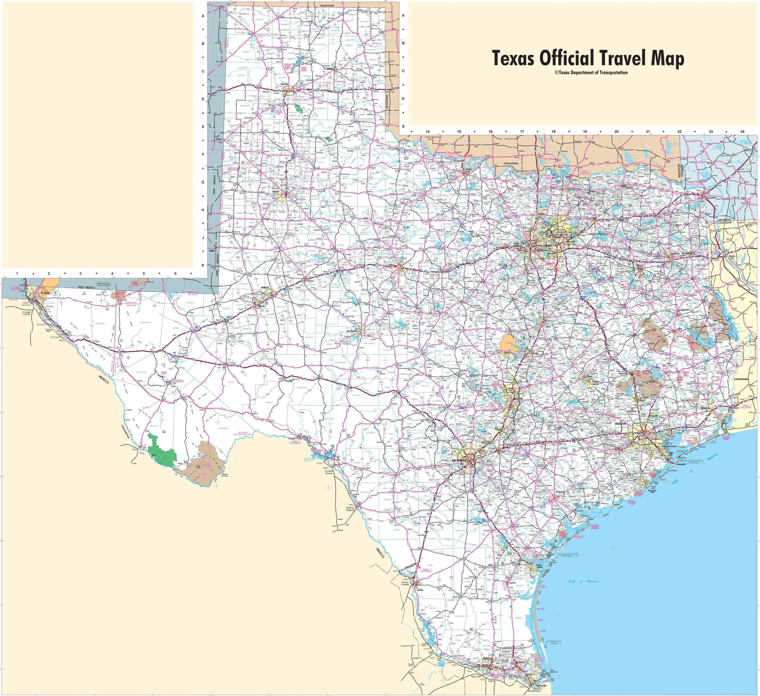
The fourth map is the main Texas map with Cities that shows all counties, major cities, city roads, and interstate highways. And the last map is a detailed map of the state of Texas. All major cities and towns are visible on this map with all major roads. And some water bodies like Lakes and Rivers are also shown on this map. So, these were some printable maps that we have added above. These large maps are available in PDF and JPG (Image) formats. You can easily download any map by clicking on the buttons under the preview image. All these maps are free to download.