Mississippi is a state located in the southeastern region of the USA. Mississippi is divided into 81 counties. And, on this page, we are providing some useful information about all counties of Mississippi along with some high-quality and printable maps. And, if you want to explore more about the counties and want to enhance your knowledge then you must scroll down the page. Now, let’s start with a printable (Mississippi) MS county map.
Printable Mississippi (MS) County Maps Collection:
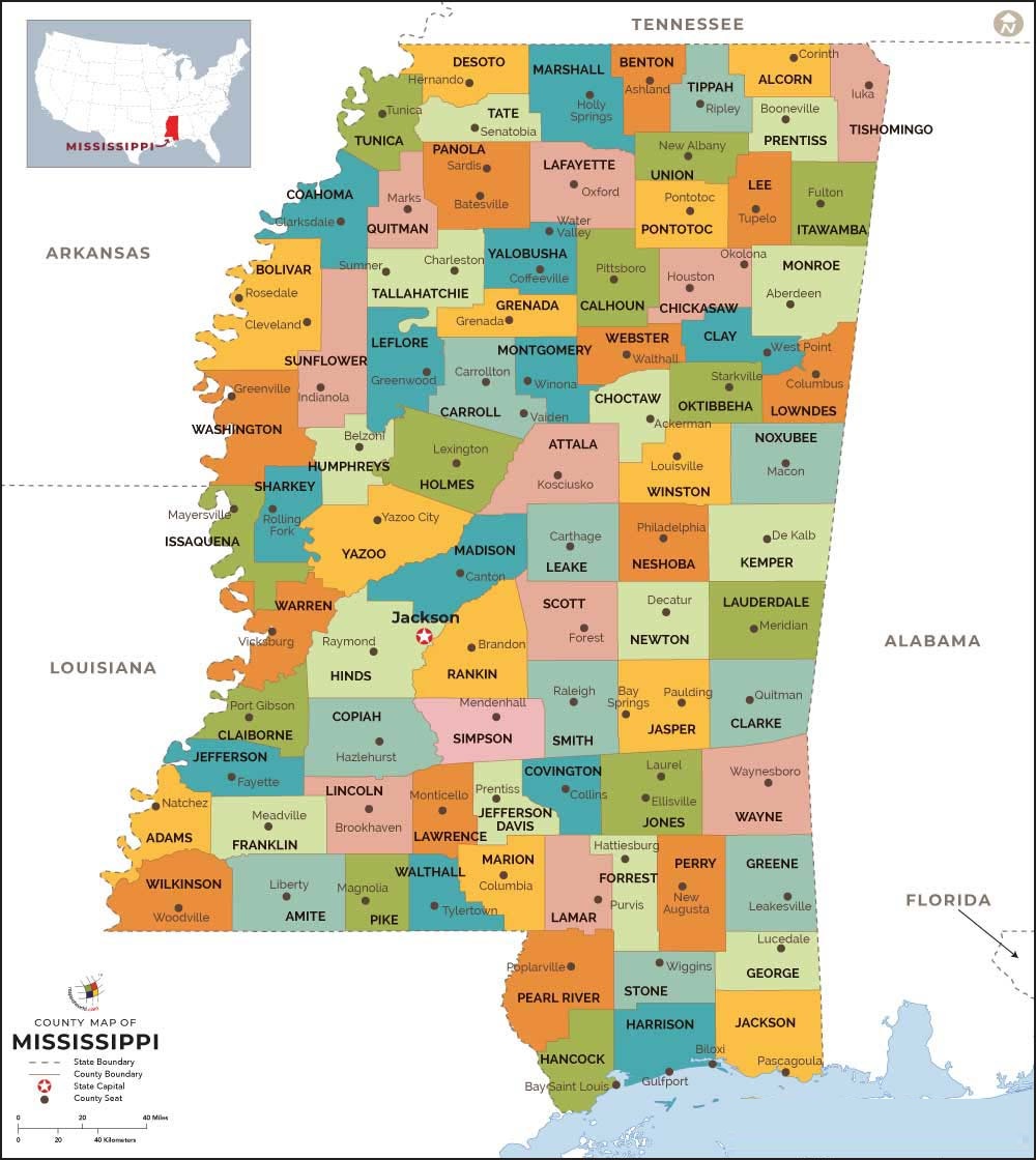
1. County Map of Mississippi:
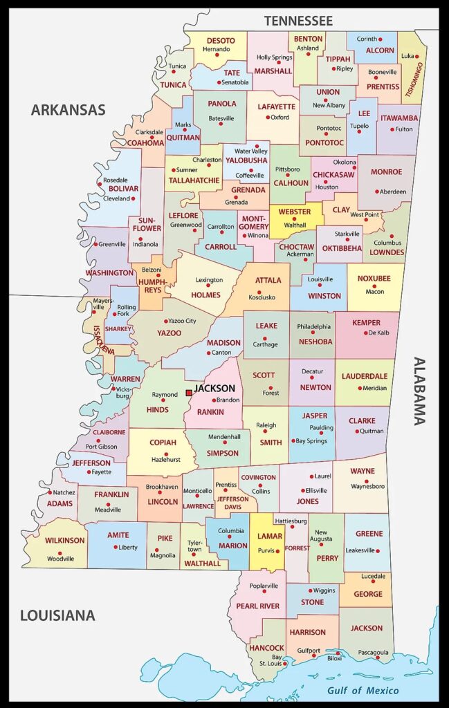
2. MS County Map:
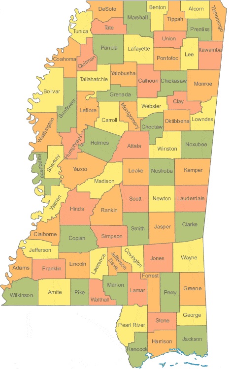
3. Map of Mississippi Counties and Cities:
4. Mississippi Map with Cities and Towns:
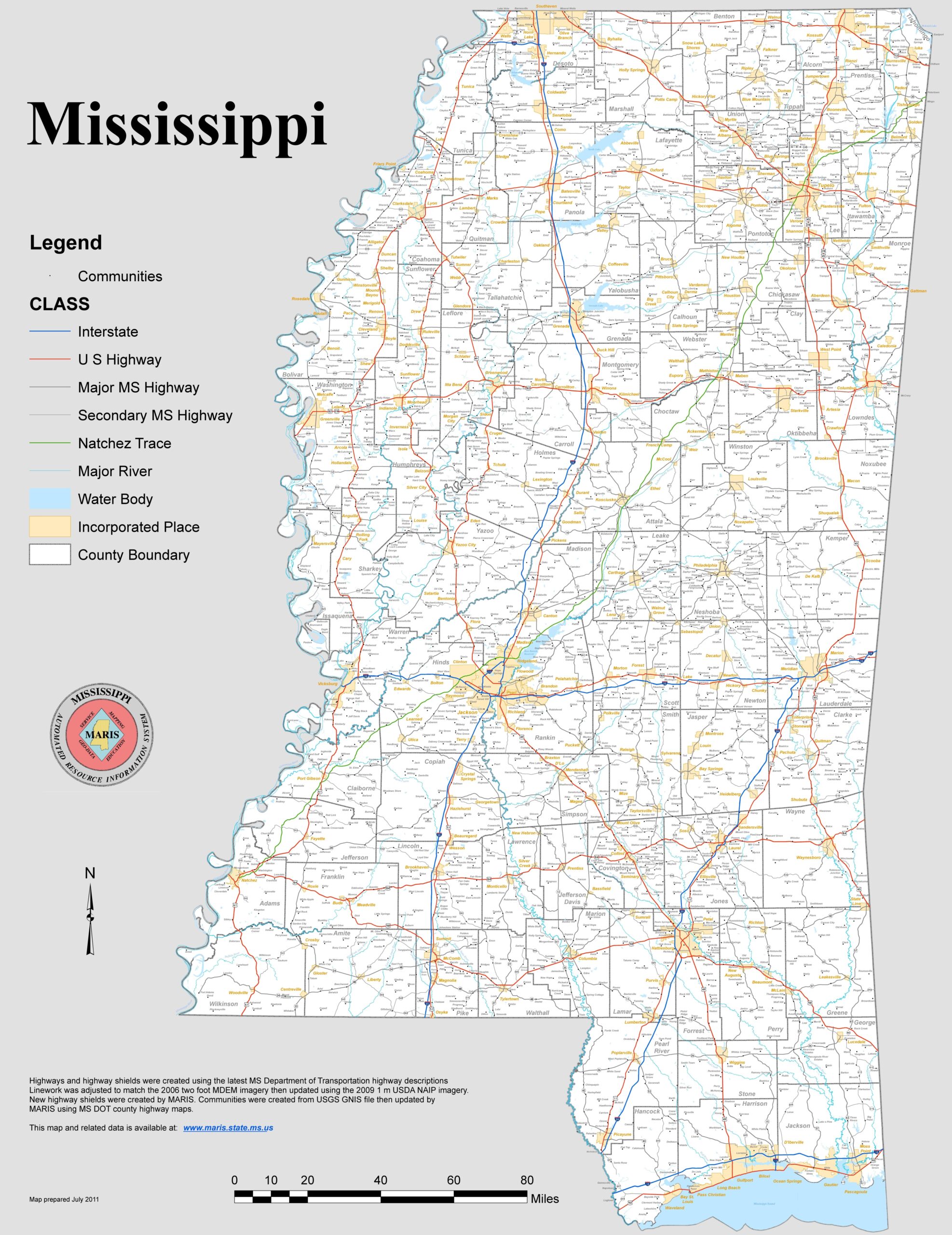
5. Mississippi Map:
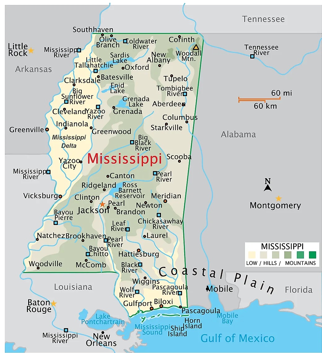
This is the collection of some MS county map that we have added above. We have added a total of six different maps that contain some helpful information about the counties and cities of Mississippi. Here, we are adding some brief information about each map. So, please read the full description before downloading any map from the above collection.
The first map is the main county map of Mississippi, which shows only county names. And the next map is also a map of MS counties with towns and cities but it is visually different. The third map is also a map of Counties. You will also see the county seat of each county. Below we are also adding a table that shows some useful information about the counties of this state. Please check the table for useful and additional information.
Counties in Mississippi, USA:
This is a list of all counties of Mississippi with some useful information like the name of the county, the county seat, year of establishment and the total area covered by these counties.
| County | County Seat Name | Est. | Population | Area |
| Adams County | Natchez | 1799 | 28742 | 460 sq mi |
| Alcorn County | Corinth | 1870 | 34349 | 400 sq mi |
| Amite County | Liberty | 1809 | 12637 | 730 sq mi |
| Attala County | Kosciusko | 1833 | 17742 | 735 sq mi |
| Benton County | Ashland | 1870 | 7646 | 407 sq mi |
| Bolivar County | Cleveland, | 1836 | 30308 | 876 sq mi |
| Calhoun County | Pittsboro | 1852 | 13018 | 587 sq mi |
| Carroll County | Carrollton | 1833 | 9879 | 628 sq mi |
| Chickasaw County | Houston, | 1836 | 17011 | 502 sq mi |
| Choctaw County | Ackerman | 1833 | 8106 | 419 sq mi |
| Claiborne County | Port Gibson | 1802 | 8908 | 487 sq mi |
| Clarke County | Quitman | 1833 | 15421 | 691 sq mi |
| Clay County | West Point | 1871 | 18535 | 409 sq mi |
| Coahoma County | Clarksdale | 1836 | 20810 | 554 sq mi |
| Copiah County | Hazlehurst | 1823 | 27995 | 777 sq mi |
| Covington County | Collins | 1819 | 18279 | 414 sq mi |
| DeSoto County | Hernando | 1836 | 188633 | 478 sq mi |
| Forrest County | Hattiesburg | 1906 | 77875 | 467 sq mi |
| Franklin County | Meadville | 1809 | 7676 | 565 sq mi |
| George County | Lucedale | 1910 | 24762 | 478 sq mi |
| Greene County | Leakesville | 1811 | 13630 | 713 sq mi |
| Grenada County | Grenada | 1870 | 21365 | 422 sq mi |
| Hancock County | Bay St. Louis | 1812 | 46055 | 477 sq mi |
| Harrison County | Gulfport, | 1841 | 209396 | 581 sq mi |
| Hinds County | Jackson, | 1821 | 222679 | 869 sq mi |
| Holmes County | Lexington | 1833 | 16496 | 756 sq mi |
| Humphreys County | Belzoni | 1918 | 7551 | 418 sq mi |
| Issaquena County | Mayersville | 1844 | 1280 | 413 sq mi |
| Itawamba County | Fulton | 1836 | 23838 | 532 sq mi |
| Jackson County | Pascagoula | 1812 | 143987 | 727 sq mi |
| Jasper County | Bay Springs, | 1833 | 16291 | 676 sq mi |
| Jefferson County | Fayette | 1799 | 7205 | 519 sq mi |
| Jefferson Davis County | Prentiss | 1906 | 11134 | 408 sq mi |
| Jones County | Laurel, | 1826 | 66744 | 694 sq mi |
| Kemper County | De Kalb | 1833 | 8829 | 766 sq mi |
| Lafayette County | Oxford | 1836 | 56884 | 631 sq mi |
| Lamar County | Purvis | 1904 | 65353 | 497 sq mi |
| Lauderdale County | Meridian | 1833 | 72088 | 704 sq mi |
| Lawrence County | Monticello | 1814 | 11812 | 431 sq mi |
| Leake County | Carthage | 1833 | 21196 | 583 sq mi |
| Lee County | Tupelo | 1866 | 82883 | 450 sq mi |
| Leflore County | Greenwood | 1871 | 27557 | 592 sq mi |
| Lincoln County | Brookhaven | 1870 | 34943 | 586 sq mi |
| Lowndes County | Columbus | 1830 | 58150 | 502 sq mi |
| Madison County | Canton | 1828 | 109813 | 719 sq mi |
| Marion County | Columbia | 1811 | 24378 | 542 sq mi |
| Marshall County | Holly Springs | 1836 | 33725 | 706 sq mi |
| Monroe County | Aberdeen | 1821 | 33883 | 764 sq mi |
| Montgomery County | Winona | 1871 | 9729 | 407 sq mi |
| Neshoba County | Philadelphia | 1833 | 28993 | 570 sq mi |
| Newton County | Decatur | 1836 | 21056 | 578 sq mi |
| Noxubee County | Macon | 1833 | 10123 | 695 sq mi |
| Oktibbeha County | Starkville | 1833 | 51842 | 458 sq mi |
| Panola County | Batesville, | 1836 | 32851 | 684 sq mi |
| Pearl River County | Poplarville | 1890 | 56503 | 812 sq mi |
| Perry County | New Augusta | 1820 | 11571 | 647 sq mi |
| Pike County | Magnolia | 1815 | 39973 | 409 sq mi |
| Pontotoc County | Pontotoc | 1836 | 31445 | 497 sq mi |
| Prentiss County | Booneville | 1870 | 24996 | 415 sq mi |
| Quitman County | Marks | 1877 | 5935 | 405 sq mi |
| Rankin County | Brandon | 1828 | 158096 | 775 sq mi |
| Scott County | Forest | 1833 | 27598 | 609 sq mi |
| Sharkey County | Rolling Fork | 1876 | 3663 | 428 sq mi |
| Simpson County | Mendenhall | 1824 | 25750 | 589 sq mi |
| Smith County | Raleigh | 1833 | 14191 | 636 sq mi |
| Stone County | Wiggins | 1916 | 18644 | 445 sq mi |
| Sunflower County | Indianola | 1844 | 25402 | 694 sq mi |
| Tallahatchie County | Charleston, | 1833 | 12366 | 644 sq mi |
| Tate County | Senatobia | 1873 | 28234 | 404 sq mi |
| Tippah County | Ripley | 1836 | 21635 | 458 sq mi |
| Tishomingo County | Iuka | 1836 | 18750 | 424 sq mi |
| Tunica County | Tunica | 1836 | 9696 | 455 sq mi |
| Union County | New Albany | 1870 | 27953 | 416 sq mi |
| Walthall County | Tylertown | 1912 | 13836 | 404 sq mi |
| Warren County | Vicksburg | 1809 | 43579 | 587 sq mi |
| Washington County | Greenville | 1827 | 43687 | 724 sq mi |
| Wayne County | Waynesboro | 1809 | 19709 | 810 sq mi |
| Webster County | Walthall | 1874 | 9983 | 423 sq mi |
| Wilkinson County | Woodville | 1802 | 8315 | 677 sq mi |
| Winston County | Louisville | 1833 | 17596 | 607 sq mi |
| Yalobusha County | Water Valley, | 1833 | 12415 | 467 sq mi |
| Yazoo County | Yazoo City | 1823 | 26373 | 920 sq mi |
The fourth map is a cities and towns map of Mississippi that shows all counties, major cities, city roads and interstate highways. And the last map is a detailed map of Mississippi. All major cities and towns are visible on this map with all major roads. And some water bodies like Lakes and Rivers are also shown on this map. So, these were some printable maps that we have added above. These large maps are available in PDF and JPG (Image) formats. You can easily download any map by clicking on the buttons under the preview image. All these maps are free to download.