Oklahoma is a popular state which is located in the South-Central region of the United States. The Roads and Highways of this state are managed by the Oklahoma Department of Transportation (ODOT) which is an agency of the government of Oklahoma. It controls all functioning and activities of the Oklahoma state. If you want to explore more about the roads and highways of this state then you should check the Oklahoma Road Map and Highway maps. Here on this page, we have added some road and highway maps of this state. Please scroll down the page and have a look at these maps.
Oklahoma Road and Highway Map Collection:
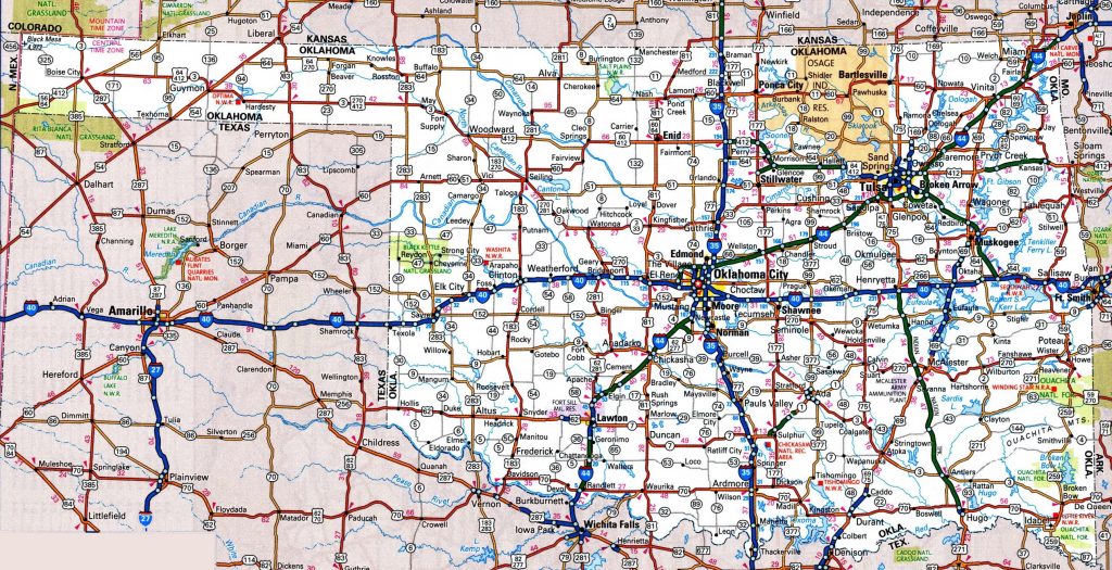
1. Oklahoma Road Map:
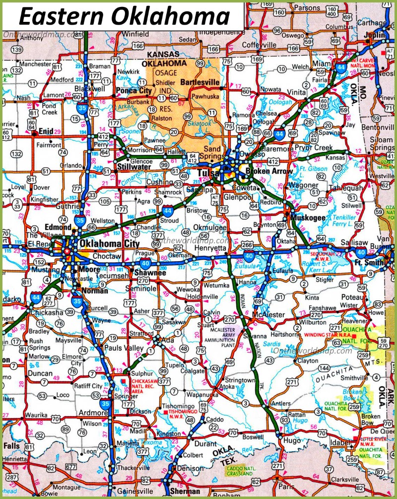
2. Road Map of East Oklahoma:
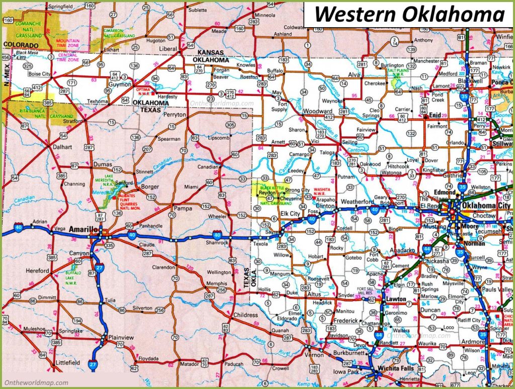
3. Road Map of West Oklahoma:
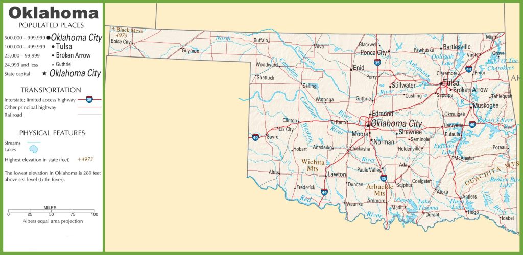
4. Oklahoma Highway Map:
As you saw that this was the collection of all the road and highway maps of Oklahoma. There is a total of four types of different maps that we have added in the above section of the page. These maps are very interactive and contain every single piece of information that you need. We have also added some specific region maps of this city. Below we are also describing each map so read the description before downloading any map.
List of Interstate Highways in Oklahoma:
| Number | Length (mi) | Length (km) |
| I-35 | 235.96 | 379.74 |
| I-40 | 331 | 533 |
| I-44 | 328.53 | 528.72 |
| I-235 | 5.36 | 8.63 |
| I-240 | 16.22 | 26.1 |
| I-244 | 15.75 | 25.35 |
List of US Highways in Oklahoma:
| Number | Length (mi) | Length (km) |
| US 54 | 56.07 | 90.24 |
| US 56 | 71.17 | 114.54 |
| US 59 | 216.47 | 348.37 |
| US 60 | 352.39 | 567.12 |
| US 62 | 402.49 | 647.74 |
| US 64 | 591.24 | 951.51 |
| US 69 | 260.82 | 419.75 |
| US 70 | 289.81 | 466.4 |
| US 75 | 249.42 | 401.4 |
| US 77 | 267.21 | 430.03 |
| US 81 | 229.28 | 368.99 |
| US 83 | 36.32 | 58.45 |
| US 169 | 73.67 | 118.56 |
| US 177 | 229.25 | 368.94 |
| US 183 | 219.94 | 353.96 |
| US 259 | 98.33 | 158.25 |
| US 266 | 43.09 | 69.35 |
| US 270 | 476.86 | 767.43 |
| US 271 | 158.32 | 254.79 |
| US 277 | 124.47 | 200.32 |
| US 281 | 255.57 | 411.3 |
| US 283 | 203.31 | 327.2 |
| US 287 | 41.41 | 66.64 |
| US 377 | 139.91 | 225.16 |
| US 385 | 35.98 | 57.9 |
| US 412 | 504.11 | 811.29 |
In the first section of “Road Maps”, there are a total of 03 maps, and all maps belong to roads of this state. There we have also added some specific region maps. So, you can easily navigate in all directions of this state. When you have a look at the first map, which is the “Oklahoma Road Map “, there you will see all the roads and their routes. You can easily navigate from this city to another city in this state. The second and third maps are related to the road map of East Oklahoma and West Oklahoma. Here, you will get to know all the information about roads and their routes that connect this city.
In the last section, there is a map which is ”Oklahoma Highway Map”. In this map, you will get to know all highways, interstate highways, and U.S. highways of this state. All interstate highways are indicated by a unique number, so you can easily identify them and navigate anywhere through any route.
These were some best road and highways maps that we have provided above. All the maps are available in PDF format as well as in JPG (Image) format. You can easily download any map by clicking on the buttons that are under the preview image. And, these maps are available free for you.