New Jersey is a state in the USA, located in the Northeastern and Mid-Atlantic regions of the country. New Jersey is also known as the “The Garden State”. There are some unknown facts and information about this state that you should know. Some of them are as – This state has the most shopping malls or stores in one place (7 malls in 25 sq area) in the world. This state is also referred to as the “Diner Capital of the World”.
You may also explore more about this state with the help of our collection of maps. Here on this page, we are adding some printable maps related to the state of New Jersey, county maps, cities, and town maps. Please scroll down the page and let’s start with a New Jersey map. You can also check some other Roads and Highway maps of New Jersey (NJ).
Collections of New Jersey Maps:
1. Map of New Jersey:

2. Northern New Jersey Map:
3. Southern New Jersey Map:

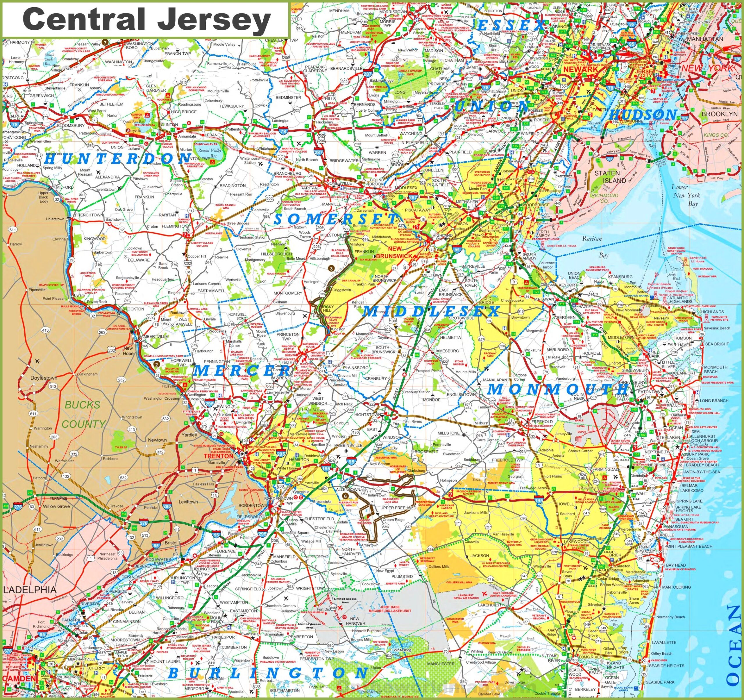
4. Central New Jersey Map:
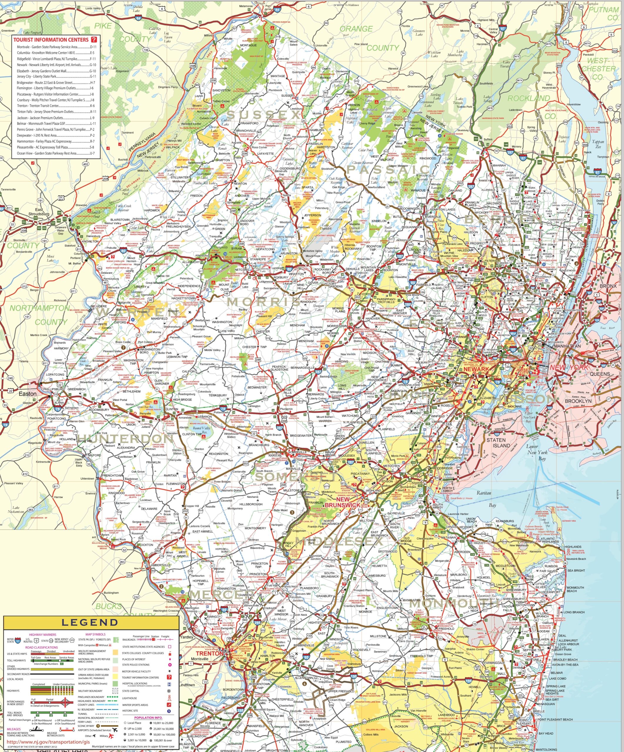
5. Detailed Map of New Jersey with Cities and Towns:

6. County Map of New Jersey:

7. New Jersey on US Map:

8. Satellite Image of New Jersey:

9. Outline / Blank Map of New Jersey:
10. Google Map of New Jersey:

11. Physical Map of New Jersey:

This is the collection of the NJ USA map that we have added above. We have added a total of eight different maps that contain some helpful information. Below, we are also adding some brief information about each map. So, please read the full description before viewing or downloading any map from the above.
The first map is related to the state map of New Jersey, which shows all counties, towns and cities on the map. Now the next three maps are the specific regional maps of this state. The second map shows all cities and towns located in Northern New Jersey, and the third map shows all towns, cities and roads in the Southern region of New Jersey. Now, the fourth map is also a regional map of this state that shows all cities, towns and villages of central New Jersey.
The fifth map shows all the cities, towns, counties, and other tourist places. It is a complete and detailed cities and towns map of New Jersey state. You can use this map if you are an explorer, traveller or tourist because, on this map, you can also know about all parks, malls, beaches, airports, railroads, street roads, city roads, interstate highways, U.S. routes, and other states’ highways. The sixth map is related to the County map of New Jersey, which shows all counties and some major cities.
Now, the seventh map shows the location of this state on the U.S.A map. As you can see, an area filled with red colour indicates NJ location. Now, the eighth map is a satellite image of New Jersey that shows the structure of this state. As you can see on the map, a thin yellow line marks the outer boundary. The ninth map is a blank outline map of this state, which shows the boundary of New Jersey.
The tenth map is a google map that shows some cities, capital city and counties of this state. And, the last map is a physical map of New Jersey, this type of map shows the height, depth, shape, mountains, desert, or water bodies of any state. So, if you are looking for such types of information then you must check this map. These were some most useful and printable New Jersey State Map that we have added above. These high-quality maps are available in PDF format and JPG (Image) format. You can easily download any map by clicking on the buttons under the preview image.