Idaho is a state in the USA located in the Pacific Northwest region. This state is covered from north to south by the Rocky Mountains. The most important mountains include the Bitterroots which extend along most of their neighbourhood mountains Montana and Caribou. If you want to explore more about the mountains of Idaho then you must check these idaho mountain ranges maps. Please scroll down the page and have a look at these maps.
Idaho Mountains Map Collection:
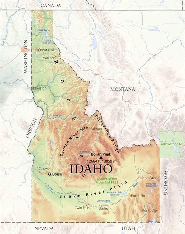
1. Idaho Mountains Map:
2. Idaho Skiing Map:
3. Selkirk Mountains Idaho Map:
4. Sun Valley Mountain Map:
5. Bitterroot Mountains Idaho Map:
So, these are the maps of the Idaho mountain range that we have added above. We assure you that these maps would be right ones for what you are looking for. Below, we are describing all maps. So, read about all maps before download any map.
Mountains ranges in Idaho State
| S.No | Name | County, State | Elevation | Coordinates |
| 1 | Albion Mountains | Cassia County, Idaho | 7,470 feet (2,280 m) | 42°13′48″N 113°43′05″W |
| 2 | Arco Hills | Butte County, Idaho | 7,310 feet (2,230 m) | 43°39′43″N 113°09′27″W |
| 3 | Aspen Range | Caribou County, Idaho | 7,831 feet (2,387 m) | 42°40′51″N 111°28′18″W |
| 4 | Bally Mountains | Box Elder County, Utah | 8,051 feet (2,454 m) | 41°57′49″N 113°28′25″W |
| 5 | Bannock Range | Bannock County, Idaho | 7,018 feet (2,139 m) | 42°25′00″N 112°17′03″W |
| 6 | Bear River Range | Bear Lake County, Idaho | 8,356 feet (2,547 m) | 42°09′17″N 111°36′15″W |
| 7 | Bear River Range | Cache County, Utah | 6,404 feet (1,952 m) | 41°38′00″N 111°40′03″W |
| 8 | Beaverhead Mountains | Lemhi County, Idaho | 11,352 feet (3,460 m) | 44°21′17″N 112°49′21″W |
| 9 | Big Hole Mountains | Teton County, Idaho | 8,655 feet (2,638 m) | 43°41′35″N 111°19′51″W |
| 10 | Bighorn Crags | Lemhi County, Idaho | 9,642 feet (2,939 m) | 45°10′24″N 114°34′59″W |
| 11 | Bitterroot Mountains | Clearwater County, Idaho | 3,845 feet (1,172 m) | 47°28′00″N 115°42′04″W |
| 12 | Bitterroot Range | Clearwater County, Idaho | 7,126 feet (2,172 m) | 46°44′08″N 115°24′27″W |
| 13 | Black Butte Hills | Lincoln County, Idaho | 4,531 feet (1,381 m) | 43°05′37″N 114°27′01″W |
| 14 | Black Pine Mountains | Cassia County, Idaho | 8,586 feet (2,617 m) | 42°07′54″N 113°07′11″W |
| 15 | Blackfoot Mountains | Bingham County, Idaho | 6,808 feet (2,075 m) | 43°10′58″N 111°50′27″W |
| 16 | Boise Mountains | Boise County, Idaho | 5,787 feet (1,764 m) | 43°45′01″N 115°30′04″W |
| 17 | Boulder Mountains | Custer County, Idaho | 11,699 feet (3,566 m) | 43°54′08″N 114°24′33″W |
| 18 | Buck Creek Mountains | Elko County, Nevada | 6,791 feet (2,070 m) | 41°55′23″N 115°35′06″W |
| 19 | Cabinet Mountains | Sanders County, Montana | 4,058 feet (1,237 m) | 48°10′00″N 115°50′04″W |
| 20 | Caribou Range | Caribou County, Idaho | 8,202 feet (2,500 m) | 42°55′14″N 111°10′54″W |
| 21 | Castle Rocks | Cassia County, Idaho | 6,758 feet (2,060 m) | 42°08′20″N 113°40′44″W |
| 22 | Cedar Hills | Cassia County, Idaho | 6,594 feet (2,010 m) | 42°00′42″N 113°41′49″W |
| 23 | Centennial Mountains | Clark County, Idaho | 10,180 feet (3,100 m) | 44°33′44″N 111°30′17″W |
| 24 | Chalk Hills | Canyon County, Idaho | 2,556 feet (779 m) | 43°36′29″N 116°48′47″W |
| 25 | Chesterfield Range | Caribou County, Idaho | 6,959 feet (2,121 m) | 42°49′52″N 111°44′47″W |
| 26 | Clearwater Mountains | Idaho County, Idaho | 4,895 feet (1,492 m) | 45°36′02″N 115°11′03″W |
| 27 | Coeur d’Alene Mountains | Sanders County, Montana | 3,497 feet (1,066 m) | 47°45′00″N 116°00′04″W |
| 28 | Cold Springs Mountains | Idaho County, Idaho | 6,926 feet (2,111 m) | 45°30′04″N 116°27′05″W |
| 29 | Cotterel Mountains | Cassia County, Idaho | 6,092 feet (1,857 m) | 42°26′20″N 113°28′22″W |
| 30 | Cuddy Mountains | Washington County, Idaho | 7,566 feet (2,306 m) | 44°49′23″N 116°43′56″W |
| 31 | Danskin Mountains | Elmore County, Idaho | 4,987 feet (1,520 m) | 43°24′39″N 115°41′36″W |
| 32 | Deep Creek Mountains | Power County, Idaho | 8,412 feet (2,564 m) | 42°26′35″N 112°42′59″W |
| 33 | Donkey Hills | Custer County, Idaho | 9,377 feet (2,858 m) | 44°13′26″N 113°30′28″W |
| 34 | East Hills | Cassia County, Idaho | 5,804 feet (1,769 m) | 42°29′04″N 113°33′55″W |
| 35 | Eastern Centennial Mountains | Clark County, Idaho | 10,180 feet (3,100 m) | 44°33′44″N 111°30′17″W |
| 36 | Elk Mountains | Elko County, Nevada | 7,398 feet (2,255 m) | 41°56′12″N 115°03′34″W |
| 37 | Fish Creek Range | Caribou County, Idaho | 6,460 feet (1,970 m) | 42°37′11″N 111°55′17″W |
| 38 | Fox Hills | Caribou County, Idaho | 7,011 feet (2,137 m) | 42°48′46″N 111°28′24″W |
| 39 | Gannett Hills | Lincoln County, Wyoming | 7,907 feet (2,410 m) | 42°33′36″N 111°04′14″W |
| 40 | Goose Creek Mountains | Elko County, Nevada | 6,102 feet (1,860 m) | 41°37′35″N 114°07′28″W |
| 41 | Grass Mountains | Idaho County, Idaho | 8,067 feet (2,459 m) | 45°10′39″N 116°11′43″W |
| 42 | Grassy Hills | Owyhee County, Idaho | 5,853 feet (1,784 m) | 42°11′26″N 115°06′02″W |
| 43 | Grays Range | Caribou County, Idaho | 7,428 feet (2,264 m) | 42°57′04″N 111°25′35″W |
| 44 | Hawley Mountains | Butte County, Idaho | 7,910 feet (2,410 m) | 44°05′07″N 113°18′30″W |
| 45 | Henrys Lake Mountains | Madison County, Montana | 10,148 feet (3,093 m) | 44°46′52″N 111°24′00″W |
| 46 | High Breaks | Idaho County, Idaho | 4,767 feet (1,453 m) | 45°52′12″N 116°31′26″W |
| 47 | Hitt Mountains | Washington County, Idaho | 6,329 feet (1,929 m) | 44°35′16″N 117°00′45″W |
| 48 | Hitt Mountains | Washington County, Idaho | 6,752 feet (2,058 m) | 44°35′51″N 116°54′00″W |
| 49 | Hoodoo Mountains | Latah County, Idaho | 4,816 feet (1,468 m) | 47°01′59″N 116°29′13″W |
| 50 | Jim Sage Mountains | Cassia County, Idaho | 8,025 feet (2,446 m) | 42°11′03″N 113°29′40″W |
| 51 | Lake Hills | Blaine County, Idaho | 6,614 feet (2,016 m) | 43°24′27″N 113°57′23″W |
| 52 | Lemhi Range | Lemhi County, Idaho | 9,442 feet (2,878 m) | 44°37′30″N 113°37′17″W |
| 53 | Lewisville Knolls | Jefferson County, Idaho | 4,918 feet (1,499 m) | 43°41′04″N 112°02′53″W |
| 54 | Little Goat Mountains | Shoshone County, Idaho | 6,043 feet (1,842 m) | 46°58′43″N 115°48′39″W |
| 55 | Little Valley Hills | Bonneville County, Idaho | 7,424 feet (2,263 m) | 43°03′30″N 111°33′03″W |
| 56 | Lost River Range | Butte County, Idaho | 8,783 feet (2,677 m) | 43°59′18″N 113°23′19″W |
| 57 | Malad Range | Oneida County, Idaho | 6,831 feet (2,082 m) | 42°03′11″N 112°08′34″W |
| 58 | Middle Mountain | Cassia County, Idaho | 7,014 feet (2,138 m) | 42°03′07″N 113°50′23″W |
| 59 | Moose Mountains | Clearwater County, Idaho | 6,735 feet (2,053 m) | 46°45′32″N 115°11′57″W |
| 60 | Mount Bennett Hills | Camas County, Idaho | 6,102 feet (1,860 m) | 43°13′11″N 115°05′29″W |
| 61 | Ninety Percent Range | Caribou County, Idaho | 6,808 feet (2,075 m) | 42°42′29″N 111°39′17″W |
| 62 | North Fork Range | Valley County, Idaho | 6,243 feet (1,903 m) | 44°09′39″N 116°03′07″W |
| 63 | North Hansel Mountains | Box Elder County, Utah | 5,259 feet (1,603 m) | 41°54′35″N 112°31′33″W |
| 64 | North Hansel Mountains | Oneida County, Idaho | 6,975 feet (2,126 m) | 42°04′17″N 112°35′35″W |
| 65 | North Junipers | Fremont County, Idaho | 5,945 feet (1,812 m) | 44°03′08″N 111°52′23″W |
| 66 | Owyhee Mountains | Owyhee County, Idaho | 8,386 feet (2,556 m) | 42°58′51″N 116°39′31″W |
| 67 | Pahsimeroi Mountains | Custer County, Idaho | 8,258 feet (2,517 m) | 44°27′27″N 114°01′47″W |
| 68 | Palouse Range | Latah County, Idaho | 4,728 feet (1,441 m) | 46°48′16″N 116°51′13″W |
| 69 | Paradise Hills | Bingham County, Idaho | 7,001 feet (2,134 m) | 43°04′29″N 111°45′14″W |
| 70 | Picabo Hills | Blaine County, Idaho | 6,211 feet (1,893 m) | 43°16′29″N 114°08′35″W |
| 71 | Pioneer Mountains | Blaine County, Idaho | 11,939 feet (3,639 m) | 43°44′57″N 114°07′51″W |
| 72 | Pleasantview Hills | Oneida County, Idaho | 6,378 feet (1,944 m) | 42°17′05″N 112°28′37″W |
| 73 | Pocatello Range | Bannock County, Idaho | 6,621 feet (2,018 m) | 42°55′47″N 112°18′47″W |
| 74 | Pole Creek Breaks | Owyhee County, Idaho | 5,814 feet (1,772 m) | 42°29′43″N 116°59′24″W |
| 75 | Portneuf Range | Bannock County, Idaho | 7,851 feet (2,393 m) | 42°48′57″N 112°08′32″W |
| 76 | Preuss Range | Caribou County, Idaho | 7,329 feet (2,234 m) | 42°18′03″N 111°10′52″W |
| 77 | Purcell Mountains | Lincoln County, Montana | 7,707 feet (2,349 m) | 48°57′48″N 115°58′06″W |
| 78 | Red Hills | Lemhi County, Idaho | 7,572 feet (2,308 m) | 44°09′55″N 113°25′45″W |
| 79 | Salmon River Mountains | Custer County, Idaho | 6,975 feet (2,126 m) | 44°39′21″N 114°12′10″W |
| 80 | Salmon River Range | Elko County, Nevada | 7,113 feet (2,168 m) | 41°50′36″N 114°50′09″W |
| 81 | Samaria Mountains | Oneida County, Idaho | 7,605 feet (2,318 m) | 42°03′31″N 112°20′45″W |
| 82 | Sand Hills | Bonneville County, Idaho | 4,715 feet (1,437 m) | 43°25′02″N 112°01′22″W |
| 83 | Sawtooth Range | Blaine County, Idaho | 9,767 feet (2,977 m) | 43°57′12″N 114°59′26″W |
| 84 | Secesh-Warren Area Mountains | Idaho County, Idaho | 8,752 feet (2,668 m) | 45°15′01″N 115°46′01″W |
| 85 | Selkirk Mountains | Boundary County, Idaho | 5,331 feet (1,625 m) | 48°30′01″N 116°45′05″W |
| 86 | Seven Devils Mountains | Idaho County, Idaho | 9,268 feet (2,825 m) | 45°18′33″N 116°33′18″W |
| 87 | Seven Sisters | Boundary County, Idaho | 6,929 feet (2,112 m) | 48°39′17″N 116°39′49″W |
| 88 | Sheep Creek Hills | Bear Lake County, Idaho | 6,539 feet (1,993 m) | 42°11′52″N 111°06′54″W |
| 89 | Sheep Hills | Owyhee County, Idaho | 5,161 feet (1,573 m) | 42°18′39″N 116°38′45″W |
| 90 | Sheep Mountain Range | Clearwater County, Idaho | 5,686 feet (1,733 m) | 46°47′30″N 115°33′53″W |
| 91 | Shoshone Range | Shoshone County, Idaho | 4,035 feet (1,230 m) | 47°50′00″N 116°00′04″W |
| 92 | Silver City Range | Owyhee County, Idaho | 7,559 feet (2,304 m) | 42°58′22″N 116°40′00″W |
| 93 | Smoky Mountains | Blaine County, Idaho | 10,118 feet (3,084 m) | 43°39′47″N 114°39′52″W |
| 94 | Snake River Range | Bonneville County, Idaho | 9,751 feet (2,972 m) | 43°23′19″N 111°05′03″W |
| 95 | Snowdrift Mountain | Caribou County, Idaho | 9,357 feet (2,852 m) | 42°32′59″N 111°13′34″W |
| 96 | Soda Springs Hills | Caribou County, Idaho | 6,699 feet (2,042 m) | 42°43′38″N 111°43′34″W |
| 97 | Soldier Mountains | Elmore County, Idaho | 6,942 feet (2,116 m) | 43°34′04″N 115°10′13″W |
| 98 | South Junipers | Fremont County, Idaho | 6,109 feet (1,862 m) | 44°00′35″N 111°51′59″W |
| 99 | St. Joe Mountains | Shoshone County, Idaho | 5,466 feet (1,666 m) | 47°25′14″N 115°57′08″W |
| 100 | Stone Hills | Oneida County, Idaho | 5,472 feet (1,668 m) | 42°01′05″N 112°47′27″W |
| 101 | Sublett Range | Power County, Idaho | 6,289 feet (1,917 m) | 42°18′00″N 112°54′58″W |
| 102 | Teton Range | Teton County, Wyoming | 9,252 feet (2,820 m) | 43°45′05″N 110°53′03″W |
| 103 | The Breaks | Jefferson County, Idaho | 4,905 feet (1,495 m) | 43°56′13″N 112°21′53″W |
| 104 | Three Buttes | Bingham County, Idaho | 7,182 feet (2,189 m) | 43°10′15″N 111°39′58″W |
| 105 | Timmerman Hills | Blaine County, Idaho | 5,627 feet (1,715 m) | 43°18′17″N 114°15′59″W |
| 106 | Trinity Mountains | Elmore County, Idaho | 6,752 feet (2,058 m) | 43°37′31″N 115°22′32″W |
| 107 | Webster Range | Caribou County, Idaho | 8,668 feet (2,642 m) | 42°46′12″N 111°11′19″W |
| 108 | West Mountains | Gem County, Idaho | 5,823 feet (1,775 m) | 44°28′00″N 116°14′04″W |
| 109 | Western Centennial Mountains | Clark County, Idaho | 9,390 feet (2,860 m) | 44°33′05″N 111°52′15″W |
| 110 | White Cloud Mountains | Custer County, Idaho | 11,788 feet (3,593 m) | 44°02′22″N 114°35′08″W |
| 111 | White Hills | Custer County, Idaho | 8,215 feet (2,504 m) | 44°31′38″N 114°03′56″W |
| 112 | White Knob Mountains | Custer County, Idaho | 8,064 feet (2,458 m) | 43°48′00″N 113°42′03″W |
| 113 | White Mountains | Custer County, Idaho | 9,600 feet (2,900 m) | 43°44′50″N 113°58′23″W |
| 114 | Williams Range | Clearwater County, Idaho | 7,087 feet (2,160 m) | 46°37′51″N 114°48′40″W |
| 115 | Wooley Range | Caribou County, Idaho | 7,208 feet (2,197 m) | 42°50′15″N 111°25′16″W |
| 116 | Yellowjacket Mountains | Lemhi County, Idaho | 8,018 feet (2,444 m) | 45°03′03″N 114°35′03″W |
The above table shows all 116 mountains that are in Idaho County and also showing some important details about the mountain like Elevation, location and coordiates.
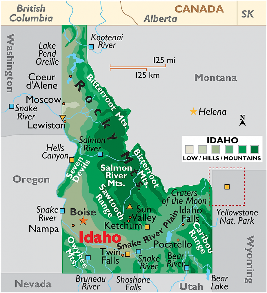
The first map is showing all mountains ranges based ontheir elevation. As you can see in the map, the green color indicates the highest peak and the light grey color indicates the lowest peak mountain range.This map is also showing all major mountains and hills that are in Idaho.
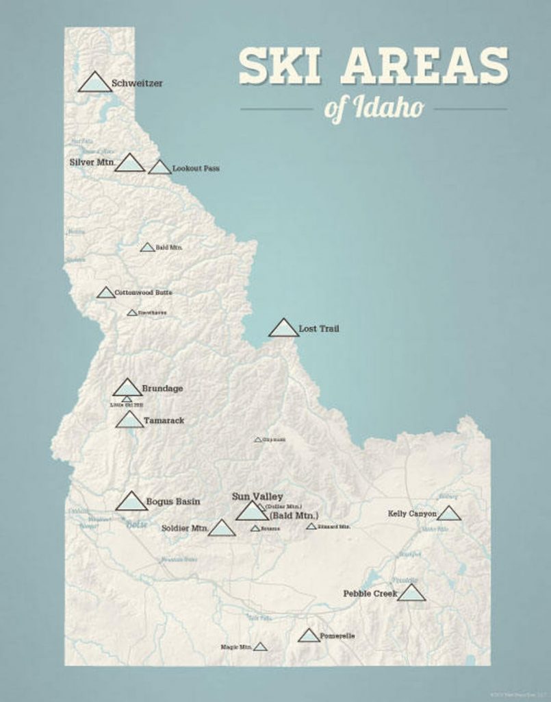
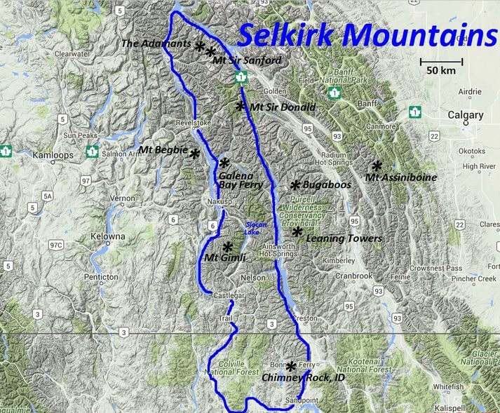
The second map is showing the skiing location in the Idaho map. You can find all the places where you can adventure activity. Check this map for more information. The third map is about the Selkrik Mountains range that is spanning in the northern region of the Idaho state.
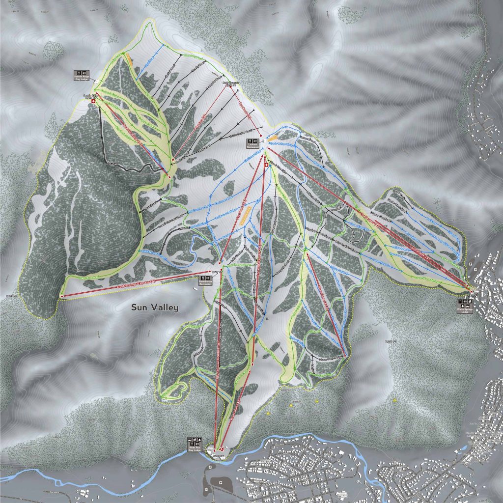
The fourth map is related to Sun Valley mountin range, this is also called resort city which is located in the Blaine County of Idaho. The elevation of this Sun Valley is 1805m (5920 feet) above the sea level. View this map for more information.
The last map is about the Bitterroot Mountains, the elevation of this mountain is 11,393 ft (3,473 m). This mountain is located in the northwestren region of the Idaho. This mountain is also a subrange of the Rocky Mountains.
All these maps are available in the PDF format as well as in JPG format. Download or save these maps according to your need.