Michigan State is located in the Midwestern region of the USA. Michigan is divided into 83 counties. Wayne County is the first county of Michigan which is formed in 1815. Wayne is also the 19th most populous county in the United States whereas Keweenaw County is the largest county in Michigan by the area (covers an area of 5,966 sq. miles). Here, on this page, we are adding some useful information about the counties of Michigan along with a printable county map of Michigan. So, scroll down the page and check our collection of MI county maps.
Michigan (MI) County Maps Collection:
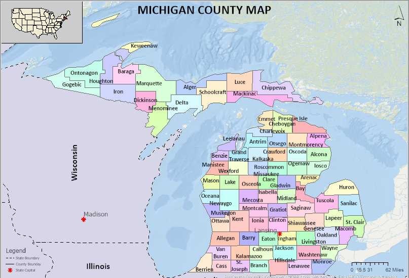
1. County Map of Michigan:

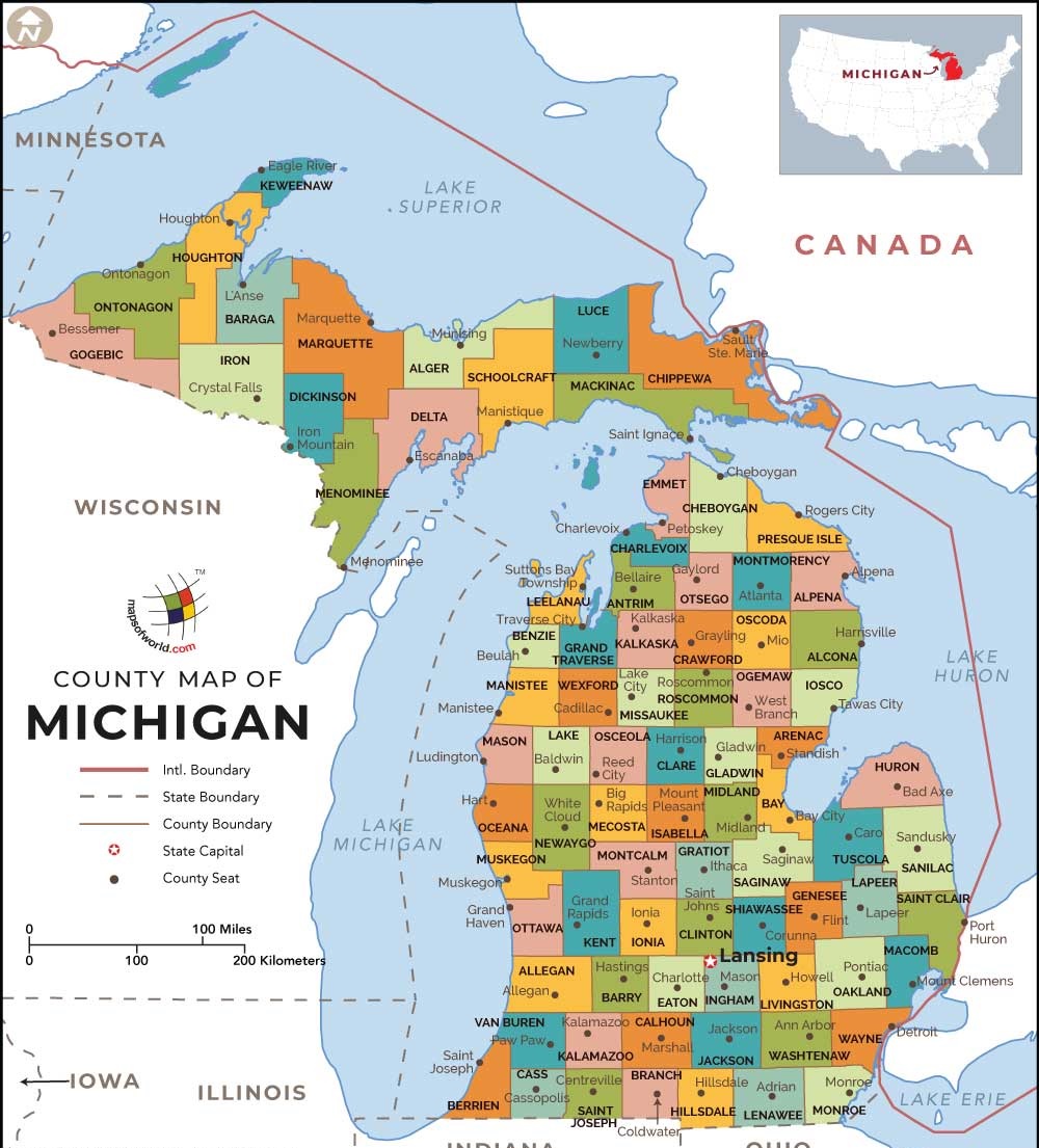
2. MI County Map:
3.County Map of Michigan with Cities:
4. Cities & Towns Map of Michigan:
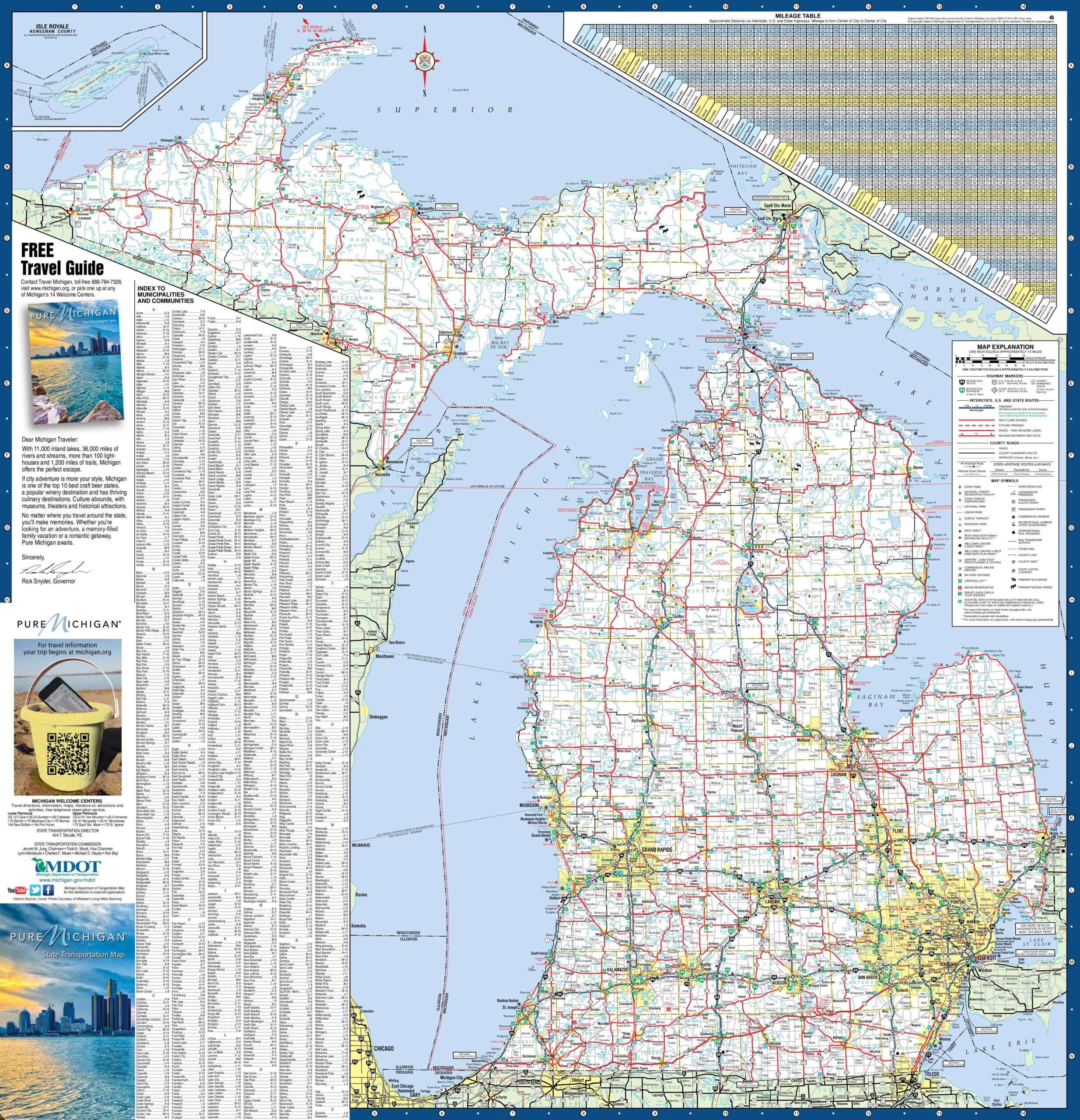
5. Map of Michigan:

This is the collection of some high-quality MI county map that we have added above. We have added a total of five different maps that contain some helpful information about the counties and cities of Michigan, USA. Here, we are adding some brief information about each map. So, please read the full description before downloading any map from the above collection.
The first map is a main county map of Michigan, which shows only county names. And the next map is also a map of Michigan with counties but it is visually different. The third map is the Michigan county map with major cities and towns. Below we are adding a list of Michigan Counties in alphabetical order. This table shows some important info about all counties. You can check the maps section if you are looking for county maps.
| S.N | County | County Seat | Population | Area | Formed |
| 1 | Alcona County | Harrisville | 10942 | 1,791 sq mi | 1840 |
| 2 | Alger County | Munising | 9601 | 5,049 sq mi | 1885 |
| 3 | Allegan County | Allegan | 111408 | 1,833 sq mi | 1831 |
| 4 | Alpena County | Alpena | 29598 | 1,695 sq mi | 1840 |
| 5 | Antrim County | Bellaire | 23598 | 602 sq mi | 1840 |
| 6 | Arenac County | Standish | 15899 | 681 sq mi | 1831 |
| 7 | Baraga County | L’Anse | 8860 | 1,069 sq mi | 1875 |
| 8 | Barry County | Hastings | 59173 | 577 sq mi | 1829 |
| 9 | Bay County | Bay City | 107771 | 631 sq mi | 1857 |
| 10 | Benzie County | Beulah | 17525 | 860 sq mi | 1863 |
| 11 | Berrien County | St. Joseph | 156813 | 1,581 sq mi | 1829 |
| 12 | Branch County | Coldwater | 45248 | 519 sq mi | 1829 |
| 13 | Calhoun County | Marshall | 136146 | 718 sq mi | 1829 |
| 14 | Cass County | Cassopolis | 52293 | 508 sq mi | 1829 |
| 15 | Charlevoix County | Charlevoix | 25949 | 1,391 sq mi | 1869 |
| 16 | Cheboygan County | Cheboygan | 26152 | 885 sq mi | 1840 |
| 17 | Chippewa County | Sault Ste. Marie | 38520 | 2,698 sq mi | 1827 |
| 18 | Clare County | Harrison | 30926 | 575 sq mi | 1840 |
| 19 | Clinton County | St. Johns | 75382 | 575 sq mi | 1831 |
| 20 | Crawford County | Grayling | 14074 | 563 sq mi | 1840 |
| 21 | Delta County | Escanaba | 37069 | 1,992 sq mi | 1843 |
| 22 | Dickinson County | Iron Mountain | 26168 | 777 sq mi | 1891 |
| 23 | Eaton County | Charlotte | 107759 | 579 sq mi | 1829 |
| 24 | Emmet County | Petoskey | 32694 | 882 sq mi | 1840 |
| 25 | Genesee County | Flint | 425790 | 649 sq mi | 1835 |
| 26 | Gladwin County | Gladwin | 25692 | 516 sq mi | 1831 |
| 27 | Gogebic County | Bessemer | 16427 | 1,476 sq mi | 1887 |
| 28 | Grand Traverse County | Traverse City | 86986 | 601 sq mi | 1851 |
| 29 | Gratiot County | Ithaca | 42476 | 572 sq mi | 1831 |
| 30 | Hillsdale County | Hillsdale | 46688 | 607 sq mi | 1829 |
| 31 | Houghton County | Houghton | 36628 | 1,502 sq mi | 1845 |
| 32 | Huron County | Bad Axe | 33118 | 2,136 sq mi | 1840 |
| 33 | Ingham County | Mason | 280895 | 561 sq mi | 1829 |
| 34 | Ionia County | Ionia | 63905 | 580 sq mi | 1831 |
| 35 | Iosco County | Tawas City | 25887 | 1,891 sq mi | 1840 |
| 36 | Iron County | Crystal Falls | 11817 | 1,211 sq mi | 1885 |
| 37 | Isabella County | Mt. Pleasant | 70311 | 578 sq mi | 1831 |
| 38 | Jackson County | Jackson | 160248 | 724 sq mi | 1829 |
| 39 | Kalamazoo County | Kalamazoo | 250331 | 580 sq mi | 1829 |
| 40 | Kalkaska County | Kalkaska | 17153 | 571 sq mi | 1840 |
| 41 | Kent County | Grand Rapids | 602622 | 872 sq mi | 1831 |
| 42 | Keweenaw County | Eagle River | 2156 | 5,966 sq mi | 1861 |
| 43 | Lake County | Baldwin | 11539 | 575 sq mi | 1840 |
| 44 | Lapeer County | Lapeer | 88319 | 663 sq mi | 1822 |
| 45 | Leelanau County | Suttons Bay Township | 21708 | 2,532 sq mi | 1840 |
| 46 | Lenawee County | Adrian | 99892 | 761 sq mi | 1822 |
| 47 | Livingston County | Howell | 1820584 | 672 sq mi | 1833 |
| 48 | Luce County | Newberry | 6631 | 1,912 sq mi | 1887 |
| 49 | Mackinac County | St. Ignace | 11113 | 2,101 sq mi | 1818 |
| 50 | Macomb County | Mt. Clemens | 840978 | 570 sq mi | 1818 |
| 51 | Manistee County | Manistee | 24733 | 1,281 sq mi | 1840 |
| 52 | Marquette County | Marquette | 67077 | 3,425 sq mi | 1843 |
| 53 | Mason County | Ludington | 28705 | 1,242 sq mi | 1840 |
| 54 | Mecosta County | Big Rapids | 42798 | 571 sq mi | 1840 |
| 55 | Menominee County | Menominee | 24029 | 1,338 sq mi | 1861 |
| 56 | Midland County | Midland | 83629 | 528 sq mi | 1831 |
| 57 | Missaukee County | Lake City | 14849 | 574 sq mi | 1840 |
| 58 | Monroe County | Monroe | 152021 | 680 sq mi | 1817 |
| 59 | Montcalm County | Stanton | 63342 | 721 sq mi | 1831 |
| 60 | Montmorency County | Atlanta | 9765 | 562 sq mi | 1840 |
| 61 | Muskegon County | Muskegon | 172188 | 1,459 sq mi | 1859 |
| 62 | Newaygo County | White Cloud | 48460 | 861 sq mi | 1840 |
| 63 | Oakland County | Pontiac | 1202362 | 908 sq mi | 1819 |
| 64 | Oceana County | Hart | 26570 | 1,307 sq mi | 1831 |
| 65 | Ogemaw County | West Branch | 21699 | 575 sq mi | 1840 |
| 66 | Ontonagon County | Ontonagon | 6780 | 3,741 sq mi | 1843 |
| 67 | Osceola County | Reed City | 23528 | 573 sq mi | 1840 |
| 68 | Oscoda County | Mio | 8640 | 572 sq mi | 1840 |
| 69 | Otsego County | Gaylord | 24164 | 526 sq mi | 1840 |
| 70 | Ottawa County | Grand Haven | 263801 | 1,632 sq mi | 1831 |
| 71 | Presque Isle County | Rogers City | 13376 | 2,573 sq mi | 1840 |
| 72 | Roscommon County | Roscommon | 24449 | 580 sq mi | 1840 |
| 73 | Saginaw County | Saginaw | 200169 | 816 sq mi | 1822 |
| 74 | Sanilac County | Sandusky | 43114 | 1,590 sq mi | 1822 |
| 75 | Schoolcraft County | Manistique | 8485 | 1,884 sq mi | 1843 |
| 76 | Shiawassee County | Corunna | 70648 | 541 sq mi | 1822 |
| 77 | St. Clair County | Port Huron | 163040 | 837 sq mi | 1820 |
| 78 | St. Joseph County | Centreville | 61295 | 521 sq mi | 1829 |
| 79 | Tuscola County | Caro | 55729 | 914 sq mi | 1840 |
| 80 | Van Buren County | Paw Paw | 76258 | 1,090 sq mi | 1829 |
| 81 | Washtenaw County | Ann Arbor | 344791 | 723 sq mi | 1822 |
| 82 | Wayne County | Detroit | 1820584 | 672 sq mi | 1815 |
| 83 | Wexford County | Cadillac | 32735 | 576 sq mi | 1840 |
The fourth map is the main Michigan map with Cities that shows all counties, major cities, city roads, and interstate highways. And the last map is a detailed map of the state of Michigan. All major cities and towns are visible on this map with all major roads. And some water bodies like Lakes and Rivers are also shown on this map. So, these were some printable maps that we have added above. These large maps are available in PDF and JPG (Image) formats. You can easily download any map by clicking on the buttons under the preview image. All these maps are free to download.