Arkansas is a beautiful state of the United States of America which is located in the South Central Region of the USA. Arkansas has approximately 144840.96 kms (90,000 miles) of rivers. A state government agency manages all rivers and lakes of this state, The Arkansas Waterways Commission. If you want to explore more about the rivers of this state, then you should stay on this page and check some major rivers maps. Here, we are providing some brief information about all rivers of Arkansas state and some major rivers maps. Please scroll down the page, and let’s start with the main river map of this state that is the Arkansas River Map.
Collection of Arkansas River Maps:
1. Arkansas River Map:
2. Rivers Map of Arkansas:

3. Ouachita River Map:
4. Arkansas River Rafting Map:
5. Caddo River Map:
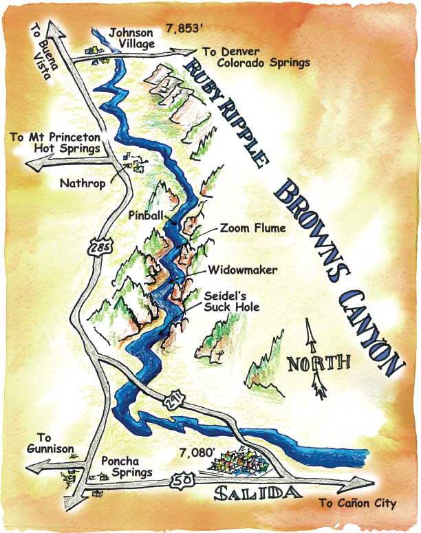
6. Browns Canyon Rafting Map:
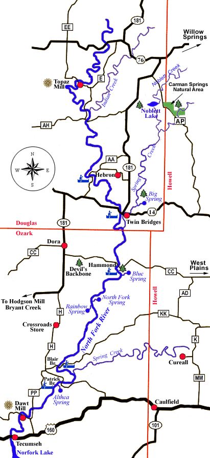
7. North Fork River Map:
So, this is the collection of the Main Arkansas river map and some other major river maps of this state. We have added seven types of different maps, including river maps, rafting maps, and other maps. So, check all maps and read each map’s description before viewing or downloading any map. Below, we are also listing a table and a list showing the name of all rivers flowing through the Arkansas state.
According to a survey, approx. Thirty-three major rivers are recognized which are flowing in Arkansas. The list of those thirty-three rivers with some brief information is mentioned below. Please check the table.
| S.No. | Name of River | Total Miles | Miles in Arkansas |
| 1 | Antoine | 35 | 35 |
| 2 | Arkansas | 1460 | 445 |
| 3 | Black | 300 | 200 |
| 4 | Boeuf | 230 | 45 |
| 5 | Buffalo | 150 | 150 |
| 6 | Cache | 213 | 164 |
| 7 | Caddo | 80 | 80 |
| 8 | Cossatot | 120 | 120 |
| 9 | Current | 225 | 40 |
| 10 | Eleven Point | 115 | 50 |
| 11 | Fourche | 20 | 20 |
| 12 | Fourche La Fave | 140 | 140 |
| 13 | Illinois | 140 | 56 |
| 14 | Kings | 115 | 100 |
| 15 | L’Anguille | 110 | 110 |
| 16 | Little | 220 | 92 |
| 17 | Little Black | 32 | 12 |
| 18 | Little Missouri | 145 | 145 |
| 19 | Little Red | 105 | 105 |
| 20 | Mississippi | 2350 | 480 |
| 21 | Moro | 105 | 105 |
| 22 | Mulberry | 70 | 70 |
| 23 | North Fork | 110 | 25 |
| 24 | Ouachita | 600 | 500 |
| 25 | Petit Jean | 113 | 113 |
| 26 | Poteau | 128 | 72 |
| 27 | Red | 1290 | 180 |
| 28 | St. Francis | 470 | 350 |
| 29 | Saline | 300 | 300 |
| 30 | Spring | 100 | 75 |
| 31 | Strawberry | 90 | 90 |
| 32 | Sulphur | 110 | 36 |
| 33 | White | 722 | 690 |
The next list is a complete list of the river that is part of Arkansas state. There is a total of fifty-eight rivers that are flowing in this state. Please check the list below.
All Rivers in Arkansas State

Antoine River
Arkansas River
Bayou De View
Bayou des Arc
Bayou Macon
Bennetts River
Big Piney Creek
Big Sugar Creek
Black River
Boeuf River
Buffalo National River or Buffalo River
Cache River
Caddo River
Cossatot River
Current River
Dorcheat Bayou
Eleven Point River
Flint Creek
Fourche La Fave River
Fourche River
Glazypeau Creek
Illinois River
James Fork
Kings River
L'Anguille River
L'Eau Frais Creek
Lee Creek
Little Antoine River
Little Black River
Little Buffalo River
Little Cossatot River
Little Maumelle River
Little Missouri River
Little Red River
Little River (Red River tributary) in southwestern Arkansas
Little River (St. Francis River tributary) in northeastern Arkansas
Little Strawberry River
Little Sugar Creek
Maumelle River
Mississippi River
Mountain Fork
Mulberry River
North Fork River
Ouachita River
Petit Jean River
Poteau River
Red River
Rolling Fork
Sager Creek
St. Francis River
Saline River (Little River tributary) in southwestern Arkansas
Saline River (Ouachita River tributary) in southern Arkansas
Spring River
Strawberry River
Sulphur River
Tanyard Creek
Tyronza River
White River
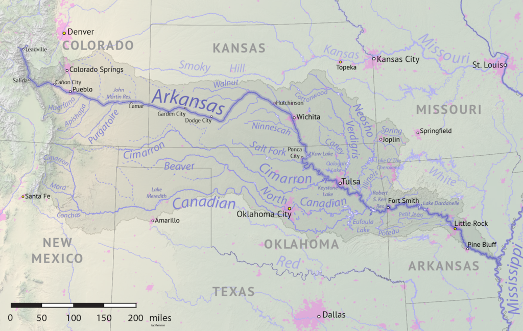
The first map is a specific map of the Arkansas River named by its state’s name. It is the main river of this state. Arkansas River is the main tributary river of the Mississippi River. It flows in the east and southeast and traverses four states of the USA. Those four states are Colorado, Kansas, Oklahoma, and Arkansas. The approx length of this river is about 1,469 mi (2,364 kms). It is also the sixth-longest river in the United States of America. The second map is a full river map of the Arkansas state which shows almost all rivers on this map. Please check the map for more information.
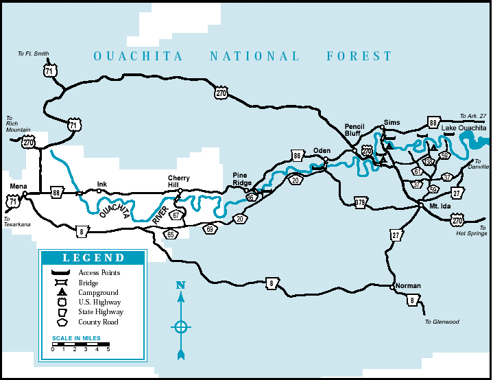
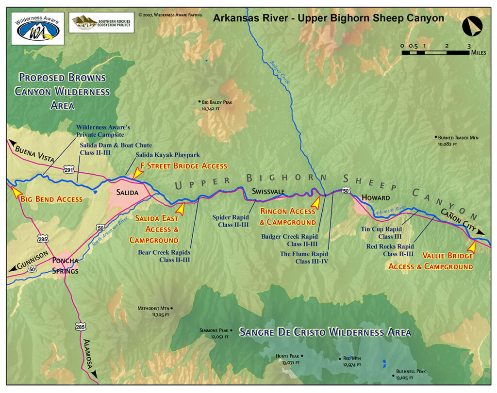
The third map is related to the Ouachita river map. This river is 605 mi (974 km) long and is located in Ouachita County, Arkansas. This river joins the Tensas River to form the Black River. The next map is about the River Rafting map of the Arkansas River. In this map, you will get to know the locations and important places where you can go rafting. All places are marked and indicated by the yellow filled arrow. Please check the map and also download this map before starting your rafting in the Arkansas River.
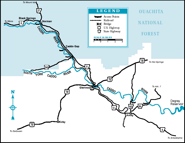
The fifth map is related to the Caddo River. This river is known as the tributary of the Ouachita River, and this river is 82 mi (132 km) long. The name of this river is inherited from a tribe of the USA, which is “Caddo”. The next map is about the Browns Canyon rafting. On this map, you can easily get to know about the best and safe rafting point of Browns Canyon National Monument, which is located along the Arkansas River. The last map is related to the North Fork River. This river is known as the tributary river of the White River, which is 109 miles long (175 kms). North Fork River is located in the Norfork city of Baxter County, Arkansas (United States).
These were some useful river maps of Arkansas state. You can get all these maps on your device without paying. All maps are available in both PDF and JPG format. Save or Download any map by clicking on the buttons that are under the preview image of each map.