Pennsylvania is located in the Mid-Atlantic, North-eastern and Appalachian parts of the USA. Pennsylvania state has sixty-seven counties. Philadelphia is the most populous county of this state while Cameron is the least populous county of Pennsylvania. If you are looking for some useful information about the counties of this state, then first you should start with a PA county map. So, please scroll down the page and have a look at the collection of maps related to Pennsylvania county, cities and towns.
Pennsylvania (PA) County Maps Collection:
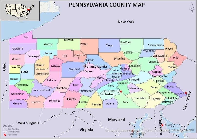
1. Pennsylvania County Map:
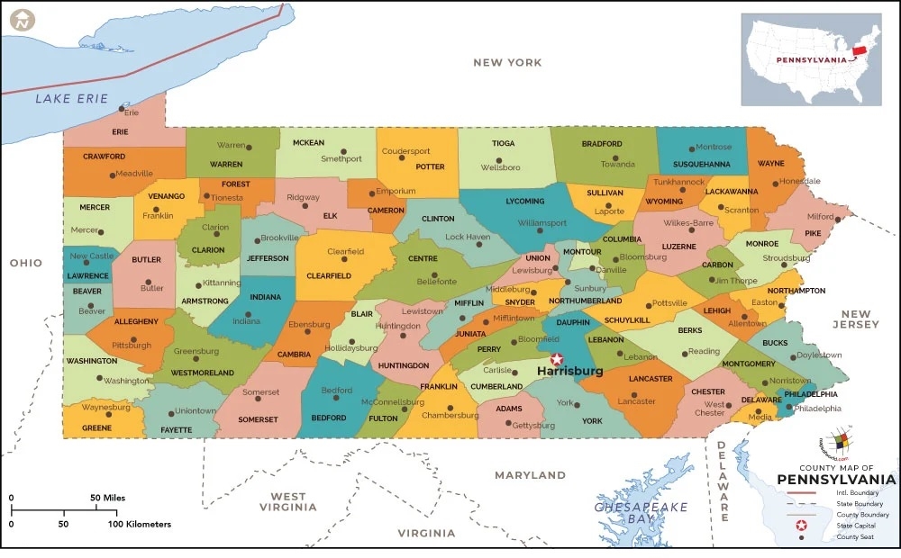
2. Map of Pennsylvania with Counties:
3. County Lines Pennsylvania:

4. PA County Map:
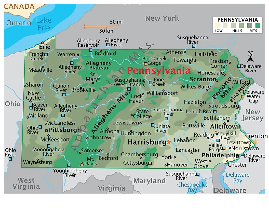
5. Pennsylvania Map:
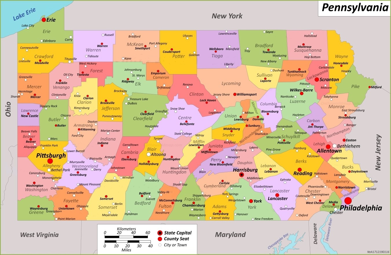
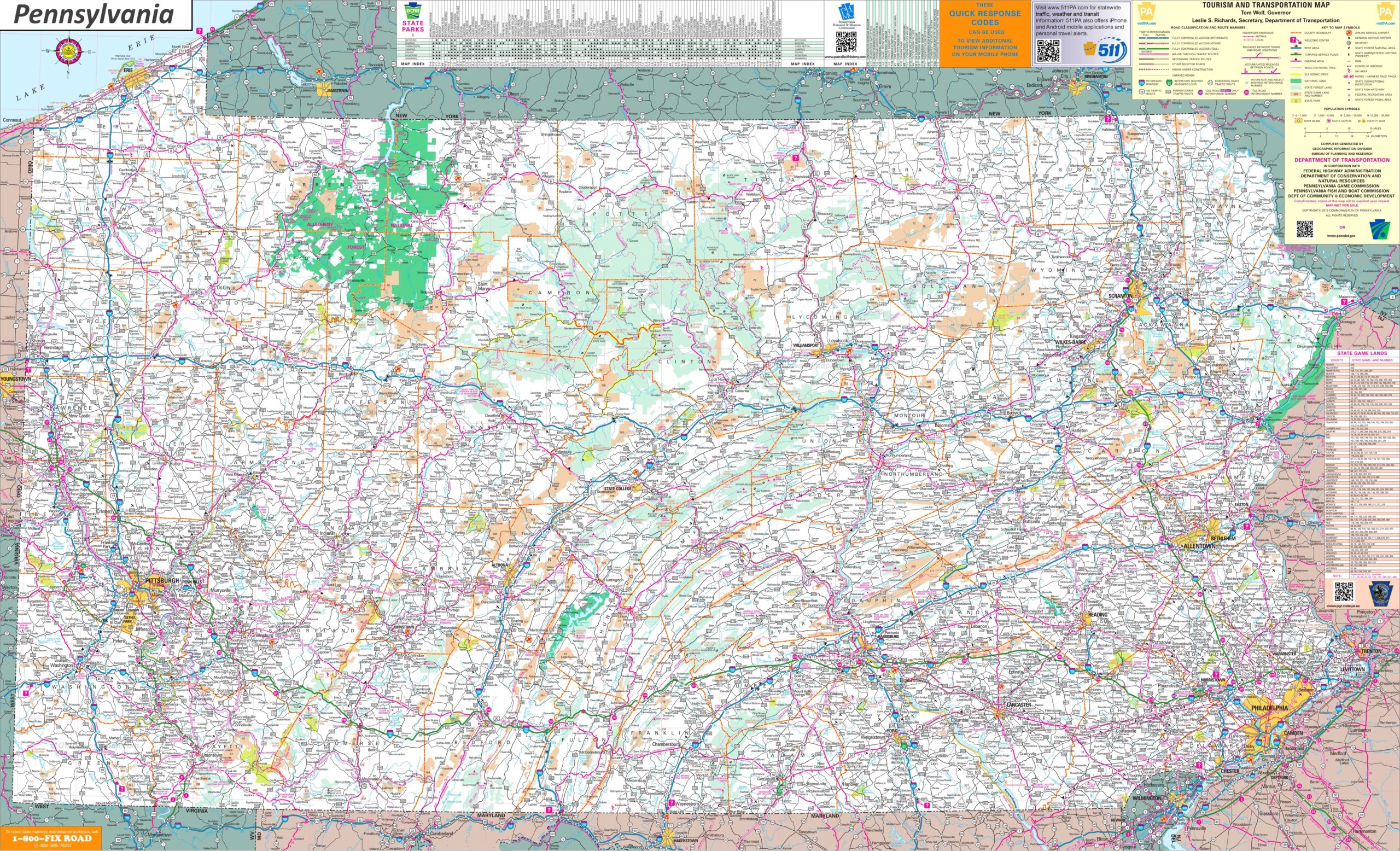
6. Pennsylvania Map with Cities and Towns:
We have added above this collection of printable maps of Pennsylvania County. We have added six maps that contain useful information about all counties of this state. Below, we are adding some brief information about each map. So, please read the full description before viewing or saving any map on any of your devices. We are also including a table that shows some useful information about counties. Please check the entire table.
List of all Counties in Pennsylvania State
| County | County Seat | Established | Population | Area |
| Adams County | Gettysburg | 1800 | 103852 | 522 sq mi |
| Allegheny County | Pittsburgh | 1788 | 1250578 | 745 sq mi |
| Armstrong County | Kittanning | 1800 | 65558 | 664 sq mi |
| Beaver County | Beaver | 1800 | 168215 | 444 sq mi |
| Bedford County | Bedford | 1771 | 47577 | 1,015 sq mi |
| Berks County | Reading | 1752 | 428849 | 866 sq mi |
| Blair County | Hollidaysburg | 1846 | 122822 | 527 sq mi |
| Bradford County | Towanda | 1810 | 59967 | 1,161 sq mi |
| Bucks County | Doylestown | 1682 | 646538 | 622 sq mi |
| Butler County | Butler | 1800 | 193763 | 795 sq mi |
| Cambria County | Ebensburg | 1804 | 133472 | 693 sq mi |
| Cameron County | Emporium | 1860 | 4547 | 399 sq mi |
| Carbon County | Jim Thorpe | 1843 | 64749 | 387 sq mi |
| Centre County | Bellefonte | 1800 | 158172 | 1,112 sq mi |
| Chester County | West Chester | 1682 | 534413 | 760 sq mi |
| Clarion County | Clarion | 1839 | 37241 | 609 sq mi |
| Clearfield County | Clearfield | 1804 | 80562 | 1,154 sq mi |
| Clinton County | Lock Haven | 1839 | 37450 | 898 sq mi |
| Columbia County | Bloomsburg | 1813 | 64727 | 490 sq mi |
| Crawford County | Meadville | 1800 | 83938 | 1,038 sq mi |
| Cumberland County | Carlisle | 1750 | 259469 | 551 sq mi |
| Dauphin County | Harrisburg | 1785 | 286401 | 558 sq mi |
| Delaware County | Media | 1789 | 576830 | 191 sq mi |
| Elk County | Ridgway | 1843 | 30990 | 832 sq mi |
| Erie County | Erie | 1800 | 270876 | 799 sq mi |
| Fayette County | Uniontown | 1783 | 128804 | 798 sq mi |
| Forest County | Tionesta | 1848 | 6973 | 431 sq mi |
| Franklin County | Chambersburg | 1784 | 155932 | 771 sq mi |
| Fulton County | McConnellsburg | 1850 | 14556 | 438 sq mi |
| Greene County | Waynesburg | 1796 | 35954 | 578 sq mi |
| Huntingdon County | Huntingdon | 1787 | 44092 | 889 sq mi |
| Indiana County | Indiana | 1803 | 83246 | 834 sq mi |
| Jefferson County | Brookville | 1804 | 44492 | 657 sq mi |
| Juniata County | Mifflintown | 1831 | 23509 | 394 sq mi |
| Lackawanna County | Scranton | 1878 | 215896 | 465 sq mi |
| Lancaster County | Lancaster | 1729 | 552984 | 984 sq mi |
| Lawrence County | New Castle | 1849 | 86070 | 363 sq mi |
| Lebanon County | Lebanon | 1813 | 143257 | 363 sq mi |
| Lehigh County | Allentown | 1812 | 374557 | 349 sq mi |
| Luzerne County | Wilkes-Barre | 1786 | 325594 | 907 sq mi |
| Lycoming County | Williamsport | 1795 | 114188 | 1,244 sq mi |
| McKean County | Smethport | 1804 | 40432 | 984 sq mi |
| Mercer County | Mercer | 1800 | 110652 | 683 sq mi |
| Mifflin County | Lewistown | 1789 | 46143 | 415 sq mi |
| Monroe County | Stroudsburg | 1836 | 168327 | 617 sq mi |
| Montgomery County | Norristown | 1784 | 856553 | 487 sq mi |
| Montour County | Danville | 1850 | 18136 | 132 sq mi |
| Northampton County | Easton | 1752 | 312951 | 377 sq mi |
| Northumberland County | Sunbury | 1772 | 91647 | 477 sq mi |
| Perry County | New Bloomfield | 1820 | 45842 | 556 sq mi |
| Philadelphia County | Philadelphia | 1682 | 1603797 | 143 sq mi |
| Pike County | Milford | 1814 | 58535 | 567 sq mi |
| Potter County | Coudersport | 1804 | 16396 | 1,081 sq mi |
| Schuylkill County | Pottsville | 1811 | 143049 | 778 sq mi |
| Snyder County | Middleburg | 1855 | 39736 | 332 sq mi |
| Somerset County | Somerset | 1795 | 74129 | 1,081 sq mi |
| Sullivan County | Laporte | 1847 | 5840 | 452 sq mi |
| Susquehanna County | Montrose | 1810 | 38434 | 832 sq mi |
| Tioga County | Wellsboro | 1804 | 41045 | 1,137 sq mi |
| Union County | Lewisburg | 1813 | 42681 | 317 sq mi |
| Venango County | Franklin | 1800 | 50454 | 683 sq mi |
| Warren County | Warren | 1800 | 38587 | 898 sq mi |
| Washington County | Washington | 1781 | 209349 | 861 sq mi |
| Wayne County | Honesdale | 1798 | 51155 | 751 sq mi |
| Westmoreland County | Greensburg | 1773 | 354663 | 1,036 sq mi |
| Wyoming County | Tunkhannock | 1842 | 26069 | 405 sq mi |
| York County | York | 1749 | 456438 | 910 sq mi |
This is a list of all counties with some additional information like name of county name, year of establishment, populations, the county seat, and total area.
The first map is the main county map of Pennsylvania State, which shows all counties. And the next map is a detailed PA county map that shows its county seat (administrator city) in Pennsylvania. The third map is a coloured blank or outlined county map. The fourth map shows all counties with towns and cities. So, check this map if you are looking for a detailed county map of Pennsylvania, USA
And the fifth map is a map state map of Pennsylvania. If you are looking for a state map and cities maps of Pennsylvania, you should click this link. The sixth map is a map of Pennsylvania with cities that shows all cities, roads, highways, rivers, and lakes. So, these were some high-quality and printable maps that we have added above. These large HD maps are available in PDF and JPG (Image) formats. You can easily download any map by clicking on the buttons under the preview image. All these maps are free to download.