Illinois is situated in the Midwest region of the United States of America. This state has almost 102 administrative counties and based-on population Cook County is the most populous county and the least populous is Hardin County. Here on this page, we are adding some high-quality county maps related to Illinois. These maps are very useful and help you to gather more information about the counties of this state. So, without any more delay, please scroll down the page and start with the IL County map.
Illinois (IL) County Maps Collection:
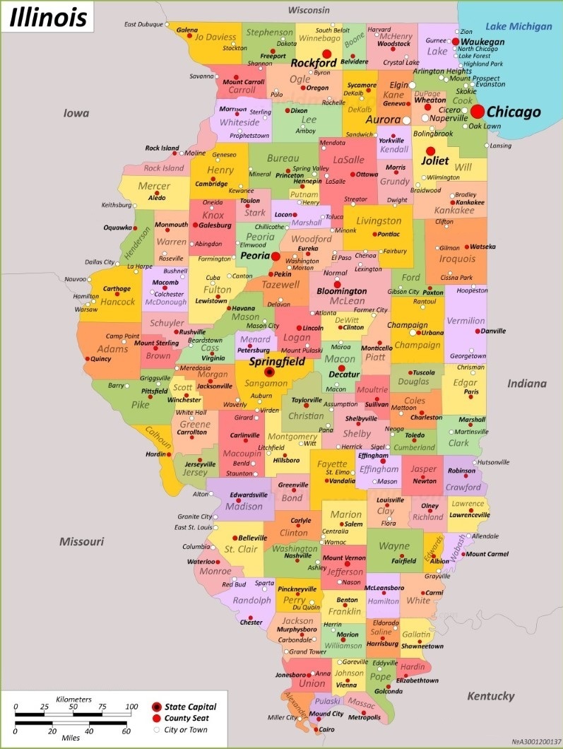
1. Illinois County Map:

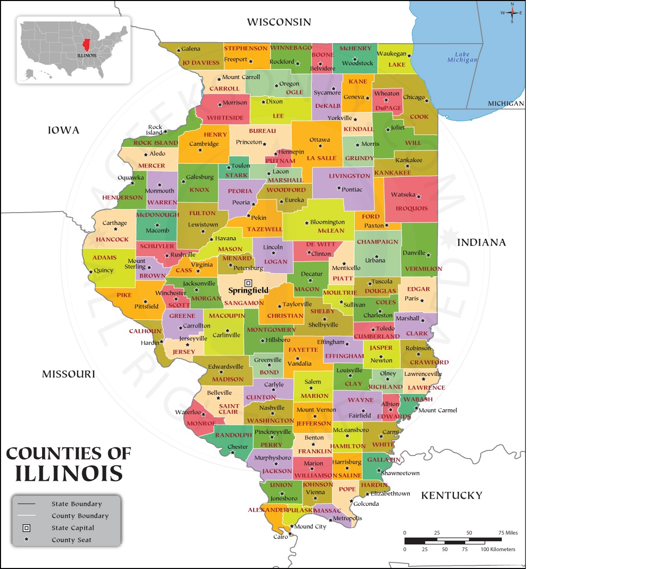
2. Map of Illinois with Counties:
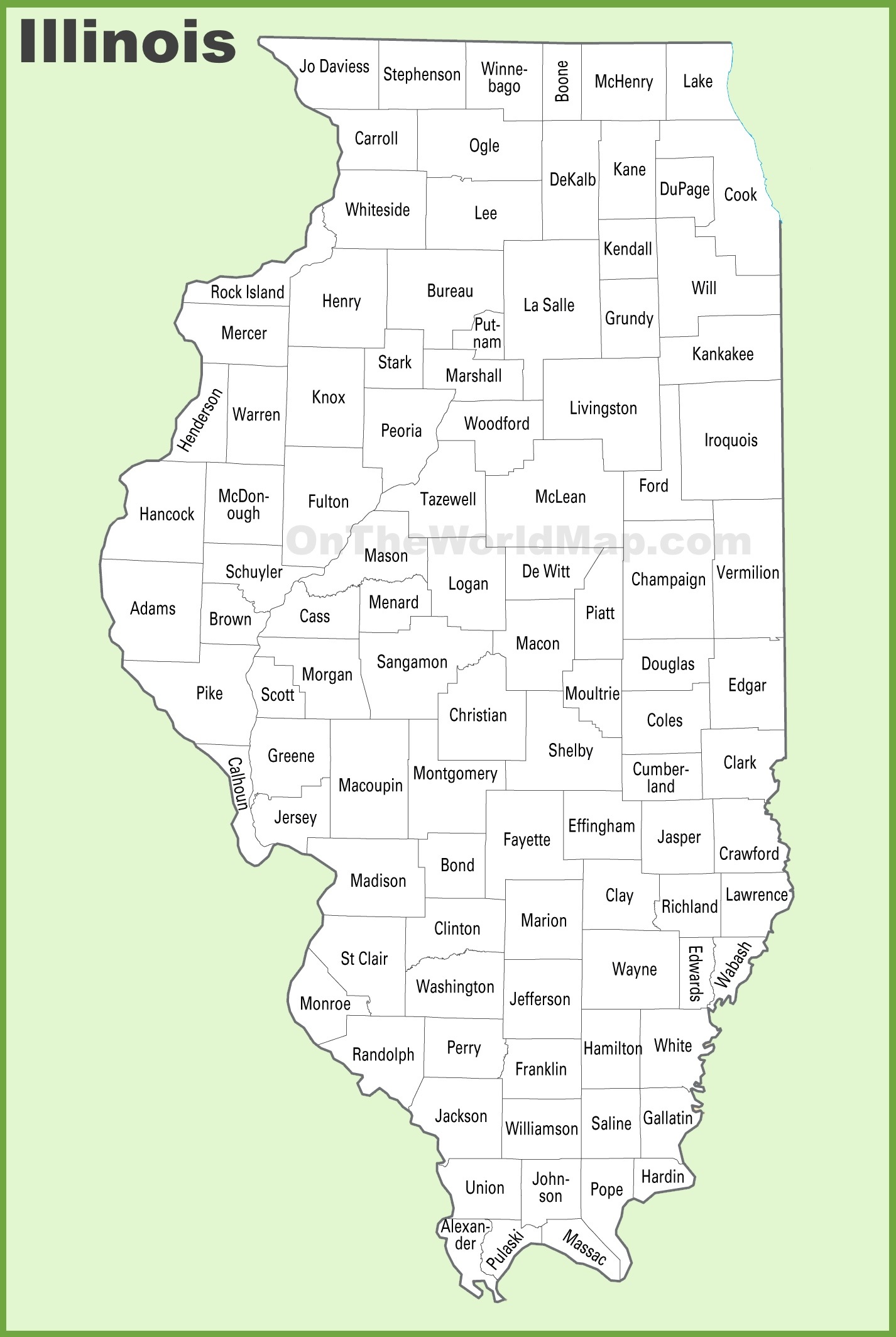
3. County Lines Illinois:
4. IL County Map:
5. Illinois Map:

6. Map of Illinois Citie:

We have added above this collection of printable maps of Illinois County. We have added six different maps that contain useful information about all counties of this state. Below, we are adding some brief information about each map. So, please read the full description before viewing or saving any map on your device. We are also including a table that shows some useful information about IL counties. Please check the entire table.
List of all Counties in Illinois State
This is a list of all counties with some additional information like name of county name, year of established in, populations, the county seat, and total area.
| County | Seat of County | Est. | Population | Area |
| Adams County | Quincy | 1825 | 65737 | 855 sq mi |
| Alexander County | Cairo | 1819 | 5240 | 236 sq mi |
| Bond County | Greenville | 1817 | 16725 | 380 sq mi |
| Boone County | Belvidere | 1837 | 53448 | 280 sq mi |
| Brown County | Mount Sterling | 1839 | 6244 | 305 sq mi |
| Bureau County | Princeton | 1837 | 33244 | 869 sq mi |
| Calhoun County | Hardin | 1825 | 4437 | 253 sq mi |
| Carroll County | Mount Carroll | 1839 | 15702 | 445 sq mi |
| Cass County | Virginia | 1837 | 13042 | 375 sq mi |
| Champaign County | Urbana | 1833 | 205865 | 996 sq mi |
| Christian County | Taylorville | 1839 | 34032 | 709 sq mi |
| Clark County | Marshall | 1819 | 15455 | 501 sq mi |
| Clay County | Louisville | 1824 | 13288 | 468 sq mi |
| Clinton County | Carlyle | 1824 | 36899 | 474 sq mi |
| Coles County | Charleston | 1830 | 46863 | 508 sq mi |
| Cook County | Chicago | 1831 | 5275541 | 944 sq mi |
| Crawford County | Robinson | 1816 | 18679 | 443 sq mi |
| Cumberland County | Toledo | 1843 | 10450 | 345 sq mi |
| DeKalb County | Sycamore | 1837 | 100420 | 631 sq mi |
| DeWitt County | Clinton | 1839 | 15516 | 397 sq mi |
| Douglas County | Tuscola | 1859 | 19740 | 416 sq mi |
| DuPage County | Wheaton | 1839 | 932877 | 327 sq mi |
| Edgar County | Paris | 1823 | 16866 | 623 sq mi |
| Edwards County | Albion | 1814 | 6245 | 222 sq mi |
| Effingham County | Effingham | 1831 | 34668 | 478 sq mi |
| Fayette County | Vandalia | 1821 | 21488 | 716 sq mi |
| Ford County | Paxton | 1859 | 13534 | 485 sq mi |
| Franklin County | Benton | 1818 | 37804 | 408 sq mi |
| Fulton County | Lewistown | 1823 | 33609 | 865 sq mi |
| Gallatin County | Shawneetown | 1812 | 4946 | 322 sq mi |
| Greene County | Carrollton | 1821 | 11985 | 543 sq mi |
| Grundy County | Morris | 1841 | 52533 | 418 sq mi |
| Hamilton County | McLeansboro | 1821 | 7993 | 434 sq mi |
| Hancock County | Carthage | 1825 | 17620 | 793 sq mi |
| Hardin County | Elizabethtown | 1839 | 3649 | 177 sq mi |
| Henderson County | Oquawka | 1841 | 6387 | 378 sq mi |
| Henry County | Cambridge | 1825 | 49284 | 822 sq mi |
| Iroquois County | Watseka | 1833 | 27077 | 1,117 sq mi |
| Jackson County | Murphysboro | 1816 | 52974 | 584 sq mi |
| Jasper County | Newton | 1831 | 9287 | 494 sq mi |
| Jefferson County | Mount Vernon | 1819 | 37113 | 571 sq mi |
| Jersey County | Jerseyville | 1839 | 21512 | 369 sq mi |
| Jo Daviess County | Galena | 1827 | 22035 | 600 sq mi |
| Johnson County | Vienna | 1812 | 13308 | 343 sq mi |
| Kane County | Geneva | 1836 | 516522 | 519 sq mi |
| Kankakee County | Kankakee | 1853 | 107502 | 676 sq mi |
| Kendall County | Yorkville | 1841 | 131869 | 320 sq mi |
| Knox County | Galesburg | 1825 | 49967 | 716 sq mi |
| Lake County | Waukegan | 1839 | 714342 | 443 sq mi |
| LaSalle County | Ottawa | 1831 | 109658 | 1,135 sq mi |
| Lawrence County | Lawrenceville | 1821 | 15280 | 372 sq mi |
| Lee County | Dixon | 1839 | 34145 | 724 sq mi |
| Livingston County | Pontiac | 1837 | 35815 | 1,043 sq mi |
| Logan County | Lincoln | 1839 | 27987 | 618 sq mi |
| Macon County | Decatur | 1829 | 103998 | 580 sq mi |
| Macoupin County | Carlinville | 1829 | 44967 | 862 sq mi |
| Madison County | Edwardsville | 1812 | 265859 | 716 sq mi |
| Marion County | Salem | 1823 | 37729 | 572 sq mi |
| Marshall County | Lacon | 1839 | 11742 | 386 sq mi |
| Mason County | Havana | 1841 | 13086 | 539 sq mi |
| Massac County | Metropolis | 1843 | 14169 | 237 sq mi |
| McDonough County | Macomb | 1826 | 27238 | 589 sq mi |
| McHenry County | Woodstock | 1836 | 310229 | 603 sq mi |
| McLean County | Bloomington | 1830 | 170954 | 1,183 sq mi |
| Menard County | Petersburg | 1839 | 12297 | 314 sq mi |
| Mercer County | Aledo | 1825 | 15699 | 561 sq mi |
| Monroe County | Waterloo | 1816 | 34962 | 385 sq mi |
| Montgomery County | Hillsboro | 1821 | 28288 | 703 sq mi |
| Morgan County | Jacksonville | 1823 | 32915 | 568 sq mi |
| Moultrie County | Sullivan | 1843 | 14526 | 335 sq mi |
| Ogle County | Oregon | 1836 | 51788 | 758 sq mi |
| Peoria County | Peoria | 1825 | 181830 | 618 sq mi |
| Perry County | Pinckneyville | 1827 | 20945 | 441 sq mi |
| Piatt County | Monticello | 1841 | 16673 | 439 sq mi |
| Pike County | Pittsfield | 1821 | 14739 | 831 sq mi |
| Pope County | Golconda | 1816 | 3763 | 368 sq mi |
| Pulaski County | Mound City | 1843 | 5193 | 199 sq mi |
| Putnam County | Hennepin | 1825 | 5637 | 160 sq mi |
| Randolph County | Chester | 1795 | 30163 | 575 sq mi |
| Richland County | Olney | 1841 | 15813 | 360 sq mi |
| Rock Island County | Rock Island | 1831 | 144672 | 427 sq mi |
| Saline County | Harrisburg | 1847 | 23768 | 379 sq mi |
| Sangamon County | Springfield | 1821 | 196343 | 868 sq mi |
| Schuyler County | Rushville | 1825 | 6902 | 437 sq mi |
| Scott County | Winchester | 1839 | 4949 | 250 sq mi |
| Shelby County | Shelbyville | 1827 | 20990 | 758 sq mi |
| St. Clair County | Belleville | 1790 | 257400 | 657 sq mi |
| Stark County | Toulon | 1839 | 5400 | 288 sq mi |
| Stephenson County | Freeport | 1837 | 44630 | 564 sq mi |
| Tazewell County | Pekin | 1827 | 131343 | 646 sq mi |
| Union County | Jonesboro | 1818 | 17244 | 413 sq mi |
| Vermilion County | Danville | 1826 | 74188 | 898 sq mi |
| Wabash County | Mount Carmel | 1824 | 11361 | 223 sq mi |
| Warren County | Monmouth | 1825 | 16835 | 542 sq mi |
| Washington County | Nashville | 1818 | 13761 | 562 sq mi |
| Wayne County | Fairfield | 1819 | 16179 | 713 sq mi |
| White County | Carmi | 1815 | 13877 | 494 sq mi |
| Whiteside County | Morrison | 1836 | 55691 | 684 sq mi |
| Will County | Joliet | 1836 | 696355 | 835 sq mi |
| Williamson County | Marion | 1839 | 67153 | 420 sq mi |
| Winnebago County | Rockford | 1836 | 285350 | 513 sq mi |
| Woodford County | Eureka | 1841 | 38467 | 527 sq mi |
The first map is the main county map of Illinois state, which shows all counties. And the next map is a detailed IL county map that shows its county seat or administrator city of this state. The third map is a blank or outlined county map. The fourth map shows all counties with towns and cities. So, check this map if you are looking for a detailed county map of Illinois, USA
And the fifth map is a map state map of Illinois. It is a full state map. So, if you are looking for a state map and cities maps of Illinois, you should click this link. The sixth map is a map of Illinois with cities that shows all cities, roads, highways, rivers, and lakes. So, these were some high-quality and printable maps that we have added above. These large HD maps are available in PDF and JPG (Image) formats. You can easily download any map by clicking on the buttons under the preview image. All these maps are free to download.