Illinois is a state in the United States of America located in the Midwestern region. It has many rivers that are famous for their beauty, but the major ones are the Illinois River, the Kankakee River, the Mississippi River, the Rock River, the Wabash River, and the Des Plaines River. If you are here to get more knowledge about these rivers by maps. Then, you must check our Illinois river maps that we have added below.
Illinois River Map Collection:
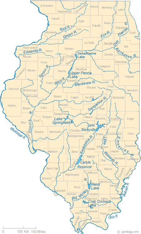
1. Illinois River Map:
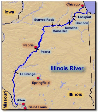
2. Map of Illinois River:
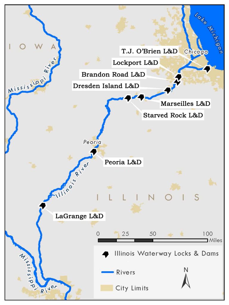
3. Illinois Waterway Map:
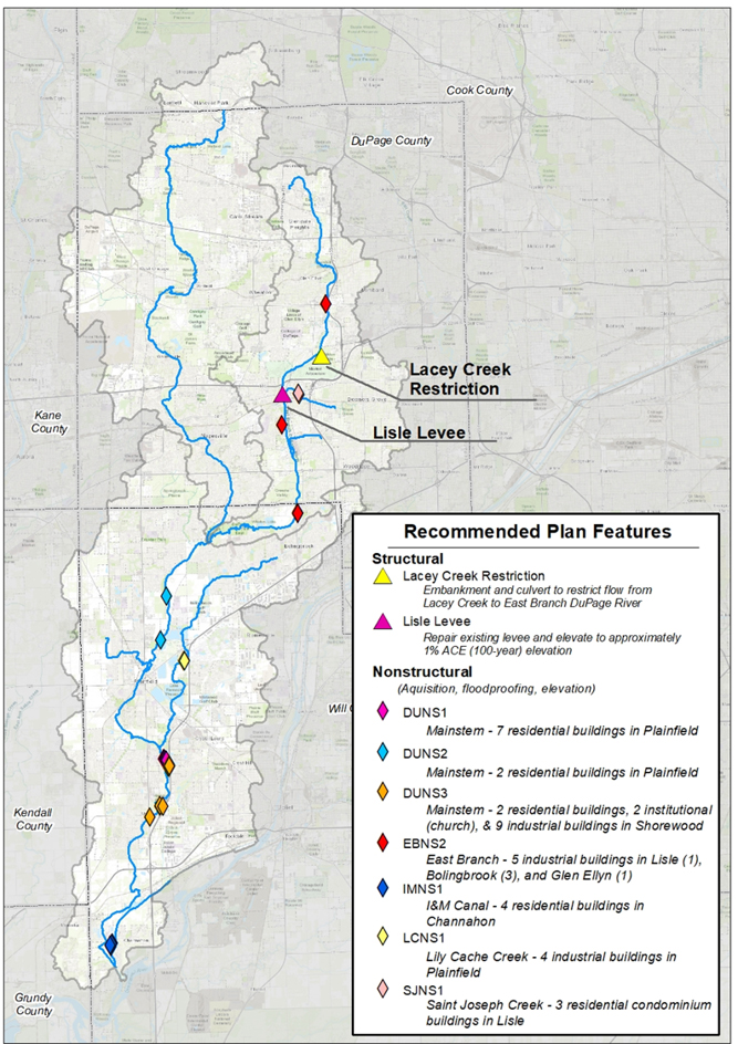
4. Dupage River Map:
5. Fox River Illinois Map:
6. Great River Road Map, Illinois:
07. Mississippi River in Illinois Map:
These are some of the important Illinois river maps that we have added above. All these maps have all the information that you are looking for. But if you want to know about all rivers that are in Illinois State. Please check the table that we are mentioning below.
| S.No | River | County | Reach | Length (miles) |
| 1 | Apple River | Carroll, JoDaviess | Wisconsin State line to Hanover (40 river miles); Hanover to mouth at Mississippi River (12 river miles) | 50 |
| 2 | Bay Creek | Johnson, Pope | Headwaters to RM 18 at Reevesville | 40 |
| 3 | Beaucoup Creek | Jackson, Perry | Rt 13-127 crossing to the confluence with Big Muddy River | 33 |
| 4 | Beaver Creek | Clinton, Bond | Clinton/Bond county line to confluence with Shoal Creek | 23 |
| 5 | Big Bureau Creek | Bureau | Epperson Run to West Bureau Creek | 5 |
| 6 | Big Creek | Hardin | From Highway 146 near Elizabethtown to confluence with Ohio River | 1 |
| 7 | Big Creek | Hardin | Headwaters west of the town of Karbers Ridge to the confluence with tributary in T11S, R8E,28NW | 3 |
| 8 | Big Creek | Hardin | Confluence with tributary in T11S, R8E,28NW south to Highway 146 near Elizabethtown | 10 |
| 9 | Big Grand Pierre Creek | Pope, Hardin | From source to the confluence with Ohio River | 16 |
| 10 | Big Indian Creek | LaSalle | Earlville to the confluence with Fox River at Wedron | 23 |
| 11 | Big Muddy River | Jackson, Franklin | S.R. 14 south of Rend Lake to Southern Illinois Airport (U.S. 51) | 52 |
| 12 | Big Muddy River | Jackson, Union | Road bridge crossing in Sec. 15 approximately one mile east of the town of SandRidge to the confluence with Mississippi River | 28 |
| 13 | Big Muddy River | Jackson | Murphysboro (one-third mile downstream from the bridge heading to 20th Street) to the boundary of Sec.14a near Gorham | 8 |
| 14 | Buck Creek | LaSalle | Headwaters to mouth at Fox River. | 16 |
| 15 | Cache River | Johnson | US 57 bridge to county Highway 3 bridge northeast of Belknap | 36 |
| 16 | Cache River | Pulaski, Union, Alexander | Choate Mental Health Center north of the Village of Anna to US 57 bridge. Then County Highway 3 bridge northeast of Belknap to the village of Ullin | 31 |
| 17 | Crabapple Creek | From E 1950th Rd in T15N, R11W, S12 to mouth at Brouilletts Creek. | 6 | |
| 18 | Crooked Creek | Clinton | Rt. 161 W. of Centralia to the confluence with the Kaskaskia River | 33 |
| 19 | Des Plaines River | Lake, Cook | Channelization near Wisconsin state line to point of several small dams near Melrose Park | 55 |
| 20 | Drummer Creek | Ford, Champaign | From headwaters south of Sibley to the confluence with Sangamon River. | 18 |
| 21 | Eagle Creek | La Salle, Livingston | From headwaters just north of Highway 18 to the confluence with Vermilion River | 11 |
| 22 | Embarras River | Jasper, Coles | Lake Charleston to Ste. Marie | 74 |
| 23 | Embarras River | Jasper, Lawrence, Crawford | From Jasper-Richland County line to confluence with Wabash River just south of Westport | 38 |
| 24 | Fox River | LaSalle, Kendall | Yorkville to Wedron | 29 |
| 25 | Fox River | Kane, McHenry, Lake, Kenosha | Wilmot WI to Algonquin (32 river miles); West Dundee dam to Elgin (6 river miles) | 41 |
| 26 | Goose Creek | Piatt | From headwaters near Mansfield to confluence with Sangamon River | 20 |
| 27 | Hadley Creek | Pike | From headwaters to McCraney Diversion Ditch | 21 |
| 28 | Henline Creek | McLean, Ford | From headwaters south of Cropsey and just east of the McLean/Ford county line to confluence with Mackinaw River. | 18 |
| 29 | Hutchins Creek | Union | Hutchins Creek between Clear Springs and Bald Knob Wilderness | 4 |
| 30 | Illinois River | Peoria | Chillicothe to Woodford-Tazewell Co. line (16 river miles) Kickapoo Creek to Pekin (11 river miles) | 21 |
| 31 | Johnny Run | Livingston, Grundy | From headwaters south of IL highway 17 to the confluence with Mazon River | 30 |
| 32 | Jordan Creek | Vermilion | From headwaters north of road 850 N (Township 18N, Range 13W, Section 23) to the confluence with Salt Fork | 12 |
| 33 | Kankakee River | Kankakee | Indiana State line to 12d boundary | 21 |
| 34 | Kaskaskia River | St. Clair, Clinton | Rt. 161 south of Carlyle to State Route 15 crossing at Fayetteville | 49 |
| 35 | Kaskaskia River | Randolph, St. Clair | Carlyle Lake to Carlyle (5 river miles); US 50 at Carlyle to ILL. 161 (12 rm); Fayetteville to chan. (24 rm); channelization north of Evansville to mouth at Mississippi River (16 rm) | 47 |
| 36 | Kishwaukee River | Boone, McHenry | Illinois Highway 176 East of Marengo to Beaver Creek | 31 |
| 37 | Kishwaukee River | Boone, Winnebago | Beaver Creek confluence to mouth at Rock River | 17 |
| 38 | LaMoine River | Schuyler | lour Creek to Cedar Creek | 15 |
| 39 | Little Muddy River | Jackson, Franklin | 0.8 mi. upstream from Jackson-Franklin County line to confluence with the Big Muddy | 25 |
| 40 | Little Vermillion River | Vermilion | Headwaters to upstream of Archie Creek near Sidell. Then from the dam at Georgetown to the state line | 28 |
| 41 | Little Wabash River | White | Carmi to the confluence with Wabash River | 32 |
| 42 | Little Wabash River | Wayne, Clay | The U.S. 50 east of Clay City to Edwards-Wayne Co. line | 70 |
| 43 | Lusk Creek | Pope | road in T12S, R6E, S3 to the confluence with Copperas Branch | 6 |
| 44 | Lusk Creek | Pope | R.M. 29 Headwaters to R.M.1, west of Golconda to (excluding from Copperous Branch up the to the road in T12S, R6E, S3) | 26 |
| 45 | Mackinaw River | Woodford, McLean | Headwaters to upstream of Money Creek Rock Creek. Then tributary in T26N, R1E to the confluence with Rock Creek | 65 |
| 46 | Mackinaw River | Tazewell, McLean | Colfax to the confluence with Illinois River (excluding Rock Creek up to tributary in T26N, R1E,33) | 65 |
| 47 | Manhattan Creek | Will | From headwaters NE of Manhattan (near the corner of Smith Road and South Cedar Road) to the confluence with Jackson Creek. | 8 |
| 48 | Mazon River | Grundy | East Fork of the Mazon River to the confluence with West Fork | 10 |
| 49 | Mazon River | Grundy, Livingston | West Fork Mazon River to Mouth | 19 |
| 50 | McKee Creek | Adams, Brown | Brown-Pike County Line to Siloam Springs State Park | 31 |
| 51 | Miller Creek | Alexander | From headwaters at the NW edge of T15S, R2W, S018 to confluence with Sexton Creek near the Mississippi River. | 8 |
| 52 | Ohio River | Pope, Hardin, Gallatin, Alexander, Pulaski, Massac | Confluence with Wabash River to Cave-in-Rock (45 rm), then from Cave-in-Rock to Cairo (95 river miles) | 129 |
| 53 | Otter Creek | La Salle, Livington | Headwaters south of Blackstone to the confluence with Vermillion River | 22 |
| 54 | Panther Creek | Woodford | From headwaters just south of Minonk to the confluence with Mackinaw River. | 27 |
| 55 | Pecatonica River | Stephenson, Winnebago | McConnel Road to Sec. 23, T27N, R7E (18 river miles); Freeport to mouth (65 river miles) | 79 |
| 56 | Piscataway Creek | McHenry | Wisconsin state line to confluence with Little Beaver Creek | 9 |
| 57 | Plum Creek | Will | Goodnow to Dyer, IN | 16 |
| 58 | Ramsey Creek | Fayette | From the confluence with Ceasar Creek to mouth at Kaskaskia River. | 16 |
| 59 | Riley Creek | Coles | From headwaters north of Mattoon at N CR 500E to mouth at Kickapoo Creek. | 15 |
| 60 | Rock River | Ogle, Lee, Whiteside, Henry | Oregon to Sterling (29 river miles); Sterling to Osborn (68 river miles) | 90 |
| 61 | Rush Creek | McHenry | From headwaters SE of Harvard to mouth at Kishwaukee River. | 16 |
| 62 | Sangamon River | McLean, Menard, Sangamon, Macon, Piatt, Champaign | From Saybrook to upstream waters of Lake Decatur. Then from Decatur dam to the confluence with Salt Creek. | 183 |
| 63 | Shoal Creek | Clinton | Confluence with Beaver Creek to mouth at Kaskaskia River | 13 |
| 64 | Spoon River | Champaign | From headwaters at US 136 near Gifford to confluence with Salt Fork | 14 |
| 65 | Spoon River | Fulton, Knox, Stark | From headwaters N of the town of Wyoming and NE of Toulon to mouth at Illinois River. | 147 |
| 66 | Spring Creek | Iroquois | 3 miles south of Onarga to mouth at Iroquois River | 33 |
| 67 | Sugar Creek | Iroquois | Upstream approximately 36 miles to where channelization begins to the confluence with Iroquois River | 36 |
| 68 | Sugar River | Winnebago | Wisconsin state line to confluence with Otter Creek | 5 |
| 69 | Ten Mile Creek | DeWitt | From headwaters just N of Toad Hill Road in T 21N, R 3E, S 28 to confluence with Salt Creek. | 19 |
| 70 | Vermilion River | Livingston, La Salle | Pontiac to Long Point Creek. Then from to tributary in Sec. 8, T31N, R3E to the confluence with Illinois River | 45 |
| 71 | Vermilion River | Livingston | Long Point Creek to Tributary in Sec. 8, T31N, R3E | 16 |
| 72 | Vermilion River, Middle Fork | Vermilion, Ford, Champaign | From Ford-Champaign County line to confluence with Knights Branch. | 27 |
| 73 | Vermilion River, Salt Fork | Vermilion, Champaign | Upstream 36 miles to where channelization begins in Champaign County to the confluence with the Middle Fork | 38 |
| 74 | Vermillion River, Middle Fork | Vermilion | Confluence with Knights Branch to river mile 46.9 near Collison. Then from river mile 29.8 at the Conrail Railroad crossing north of U.S. Highway 150 to mouth | 4 |
| 75 | Walnut Creek | Woodford | From headwaters to the confluence with Mackinaw River | 25 |
| 76 | West Branch Little Wabash River | Shelby | From headwaters to the confluence with Little Wabash River | 12 |
| 77 | West Okaw River | Moultrie | From the confluence with Stringtown Branch to mouth at Lake Shelbyville | 19 |
The first map shows all the rivers along with the cities name. In this map, you can easily find all the rivers and lakes of Illinois state. The second map is showing only the Illinois River. It flows generally west across the state and to the north of Hennepin, where it suddenly joins the Mississippi River at Grafton.
The third map is related to an Illinois waterway system consisting of 541 km in length, its origin from the mouth of the Calumet River in Chicago and ends to the mouth of the Illinois River.
The fourth one shows the Dupage River and its branches. The west branch of the DuPage River, 56.3 km long, begins at Campanelli Park in Schaumburg within Cook County and passes south through the entire county of DuPage, including the towns of Bartlett, Wheaton, Warrenville, Winfield, and Naperville.
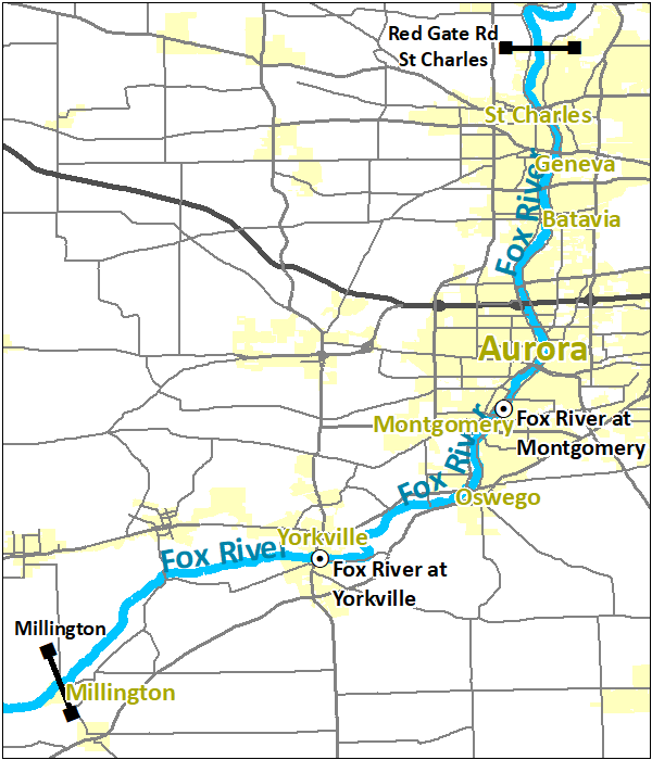
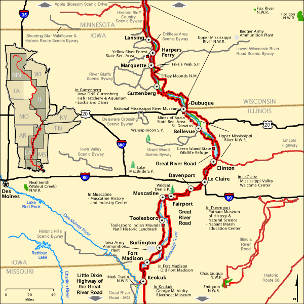
The fifth map is related to Fox River, Illinois. This river is 325 km long which flows from southeastern Wisconsin to Ottawa and Illinois in the United States. The sixth map shows the Great River Road, which is a collection of state roads and follows the Mississippi River along with ten states of the United States. And, those states are Minnesota, Wisconsin, Iowa, Illinois, Missouri, Kentucky, Tennessee, Arkansas, Mississippi and Louisiana.
The seventh map is about the Mississippi River. In this map, you can see the location of the Mississippi River that is flowing through Illinois State.
Above were some river maps of Illinois state. These maps are available in both PDF and JPG format. Save or Download any map by clicking on the buttons that are under the preview image of each map.