Iowa (IA) is located in the Midwestern region of the USA. This state is bordered by the six states of the USA and has 99 Counties. Here on this page, we are adding some information about each county with some printable and large county maps. Please scroll down the page and check our collection of County Map of Iowa. These maps will help you learn about the Counties and cities of Maine. And for additional information, you can also check some other Maine maps by clicking this link. You may also check some other maps of the Roads and Highways of Iowa (IA). So, click this link for such maps.
Iowa (IA) County Maps Collection:
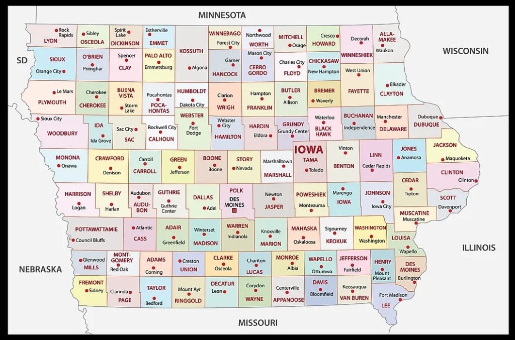
1. County Map of Iowa:
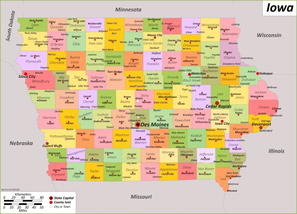
2. Iowa County Map with Cities:
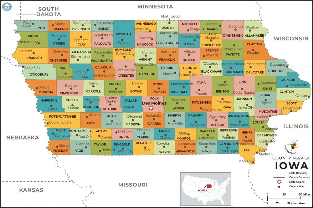
3. Iowa County map:
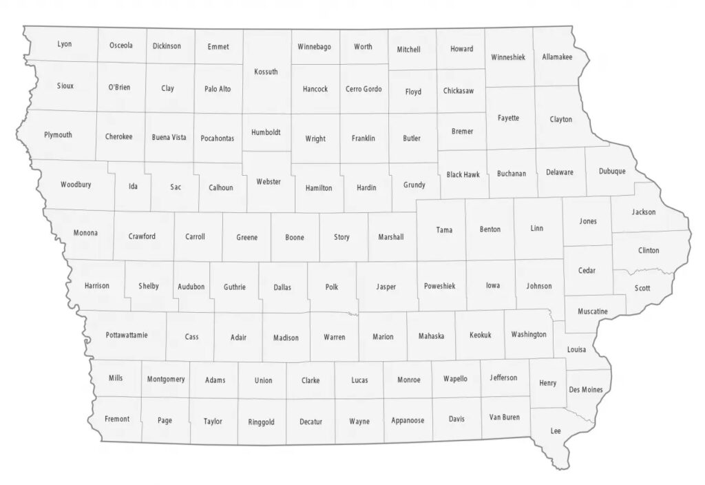
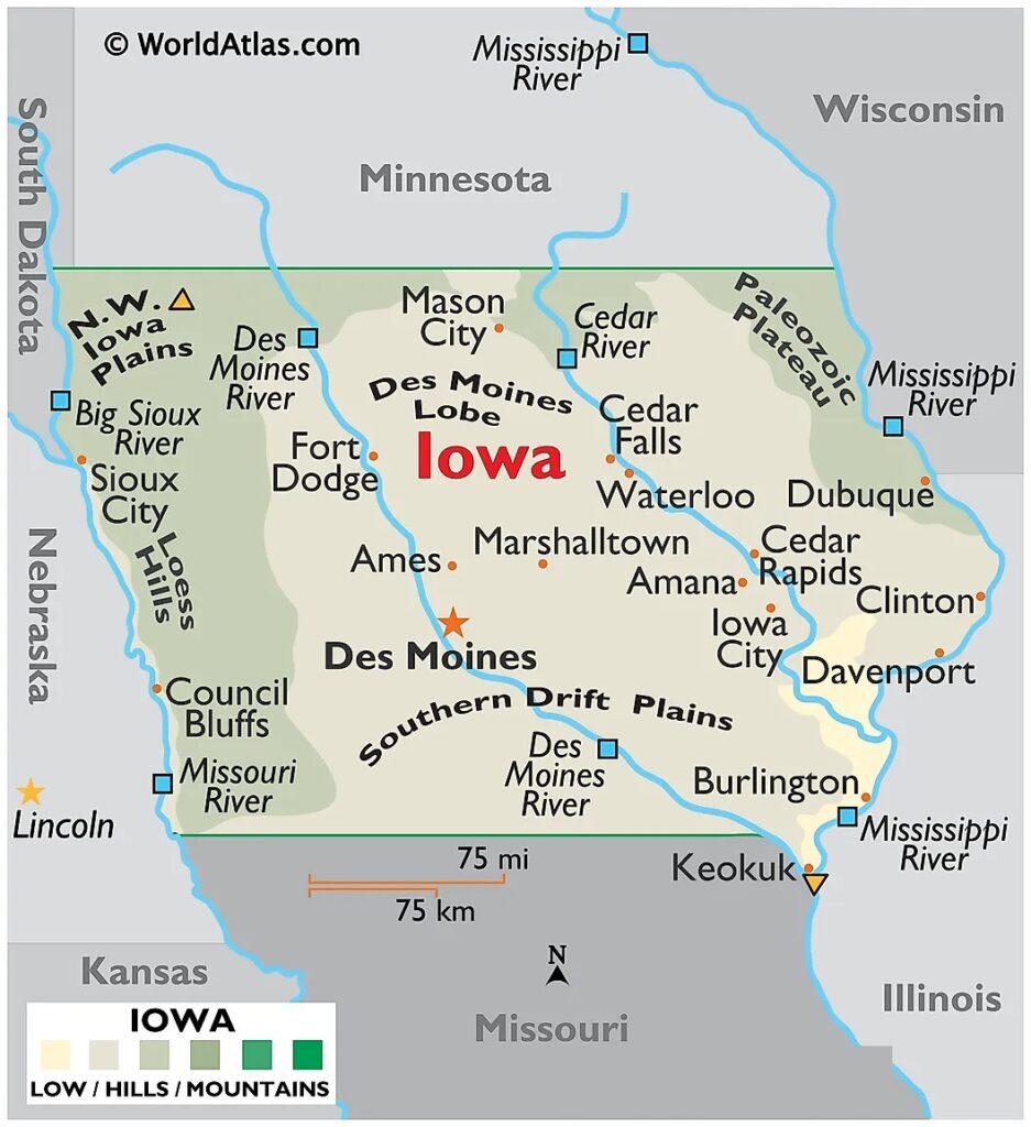
4. County map of IA:
5. Map of Iowa:
6. Iowa Map with Cities and Towns:

Here, we have added six types of county maps. Each map contains some useful information. For you, we are also adding some more useful information about each county. So, read the description and save any map for any work or purpose. We are also adding a table that shows some information about the counties of Iowa, USA.
List of all Counties in the Iowa, USA (IA):
With the help of this table, you will get some quick information about the counties. And for some additional information, you can check the first map which is a county map of Iowa.
| County Name | Population | Area | Est. | County Seat |
| Adair County | 7496 | 569 sq mi | Jan 15, 1851 | Greenfield |
| Adams County | 3704 | 424 sq mi | Jan 15, 1851 | Corning |
| Allamakee County | 14061 | 640 sq mi | Feb 20, 1847 | Waukon |
| Appanoose County | 12317 | 496 sq mi | Feb 17, 1843 | Centerville |
| Audubon County | 5674 | 443 sq mi | Jan 15, 1851 | Audubon |
| Benton County | 25575 | 716 sq mi | Dec 21, 1837 | Vinton |
| Black Hawk County | 131144 | 567 sq mi | Feb 17, 1843 | Waterloo |
| Boone County | 26715 | 572 sq mi | Jan 13, 1846 | Boone |
| Bremer County | 24988 | 428 sq mi | Jan 15, 1851 | Waverly |
| Buchanan County | 20565 | 571 sq mi | Dec 21, 1837 | Independence |
| Buena Vista County | 20823 | 575 sq mi | Jan 15, 1851 | Storm Lake |
| Butler County | 14334 | 580 sq mi | Jan 15, 1851 | Allison |
| Calhoun County | 9927 | 570 sq mi | Jan 15, 1851 | Rockwell City |
| Carroll County | 20760 | 569 sq mi | Jan 15, 1851 | Carroll |
| Cass County | 13127 | 564 sq mi | Jan 15, 1851 | Atlantic |
| Cedar County | 18505 | 580 sq mi | Dec 21, 1837 | Tipton |
| Cerro Gordo County | 43127 | 568 sq mi | Jan 15, 1851 | Mason City |
| Cherokee County | 11658 | 577 sq mi | Jan 15, 1851 | Cherokee |
| Chickasaw County | 12012 | 505 sq mi | Jan 15, 1851 | New Hampton |
| Clarke County | 9748 | 431 sq mi | Jan 13, 1846 | Osceola |
| Clay County | 16384 | 569 sq mi | Jan 15, 1851 | Spencer |
| Clayton County | 17043 | 779 sq mi | Dec 21, 1837 | Elkader |
| Clinton County | 46460 | 695 sq mi | Dec 21, 1837 | Clinton |
| Crawford County | 16525 | 714 sq mi | Jan 15, 1851 | Denison |
| Dallas County | 99678 | 586 sq mi | Jan 13, 1846 | Adel |
| Davis County | 9110 | 503 sq mi | Feb 17, 1843 | Bloomfield |
| Decatur County | 7645 | 532 sq mi | Jan 13, 1846 | Leon |
| Delaware County | 17488 | 578 sq mi | Dec 21, 1837 | Manchester |
| Des Moines County | 38910 | 416 sq mi | Sep 6, 1834 | Burlington |
| Dickinson County | 17703 | 381 sq mi | Jan 15, 1851 | Spirit Lake |
| Dubuque County | 99266 | 608 sq mi | Sep 6, 1834 | Dubuque |
| Emmet County | 9388 | 396 sq mi | Jan 15, 1851 | Estherville |
| Fayette County | 19509 | 731 sq mi | Dec 21, 1837 | West Union |
| Floyd County | 15627 | 501 sq mi | Jan 15, 1851 | Charles City |
| Franklin County | 10019 | 582 sq mi | Jan 15, 1851 | Hampton |
| Fremont County | 6605 | 511 sq mi | Feb 24, 1847 | Sidney |
| Greene County | 8771 | 568 sq mi | Jan 15, 1851 | Jefferson |
| Grundy County | 12329 | 503 sq mi | Jan 15, 1851 | Grundy Center |
| Guthrie County | 10623 | 591 sq mi | Jul 8, 1851 | Guthrie Center |
| Hamilton County | 15039 | 577 sq mi | Dec 22, 1856 | Webster City |
| Hancock County | 10795 | 571 sq mi | Jan 15, 1851 | Garner |
| Hardin County | 16878 | 569 sq mi | Jan 15, 1851 | Eldora |
| Harrison County | 14582 | 697 sq mi | Jan 15, 1851 | Logan |
| Henry County | 20482 | 434 sq mi | Dec 7, 1836 | Mount Pleasant |
| Howard County | 9469 | 473 sq mi | Jan 15, 1851 | Cresco |
| Humboldt County | 9597 | 434 sq mi | Feb 26, 1857 | Dakota City |
| Ida County | 7005 | 432 sq mi | Jan 15, 1851 | Ida Grove |
| Iowa County | 16662 | 586 sq mi | Feb 17, 1843 | Marengo |
| Jackson County | 19485 | 636 sq mi | Dec 21, 1837 | Maquoketa |
| Jasper County | 37813 | 730 sq mi | Jan 13, 1846 | Newton |
| Jefferson County | 15663 | 435 sq mi | Jan 21, 1839 | Fairfield |
| Johnson County | 152854 | 614 sq mi | Dec 21, 1837 | Iowa City |
| Jones County | 20646 | 575 sq mi | Dec 21, 1837 | Anamosa |
| Keokuk County | 10033 | 579 sq mi | Dec 21, 1837 | Sigourney |
| Kossuth County | 14828 | 973 sq mi | Jan 15, 1851 | Algona |
| Lee County | 33555 | 517 sq mi | Dec 7, 1836 | Fort Madison and Keokuk |
| Linn County | 230299 | 718 sq mi | Dec 21, 1837 | Cedar Rapids |
| Louisa County | 10837 | 402 sq mi | Dec 7, 1836 | Wapello |
| Lucas County | 8634 | 431 sq mi | Jan 13, 1846 | Chariton |
| Lyon County | 11934 | 588 sq mi | Jan 15, 1851 | Rock Rapids |
| Madison County | 16548 | 561 sq mi | Jan 13, 1846 | Winterset |
| Mahaska County | 22190 | 571 sq mi | Feb 17, 1843 | Oskaloosa |
| Marion County | 33414 | 554 sq mi | Jun 10, 1845 | Knoxville |
| Marshall County | 40105 | 572 sq mi | Jan 13, 1846 | Marshalltown |
| Mills County | 14484 | 437 sq mi | Jan 15, 1851 | Glenwood |
| Mitchell County | 10565 | 469 sq mi | Jan 15, 1851 | Osage |
| Monona County | 8751 | 693 sq mi | Jan 15, 1851 | Onawa |
| Monroe County | 7577 | 433 sq mi | Feb 17, 1843 | Albia |
| Montgomery County | 10330 | 424 sq mi | Jan 15, 1851 | Red Oak |
| Muscatine County | 43235 | 439 sq mi | Dec 7, 1836 | Muscatine |
| O’Brien County | 14182 | 573 sq mi | Jan 15, 1851 | Primghar |
| Osceola County | 6192 | 399 sq mi | Jan 15, 1851 | Sibley |
| Page County | 15211 | 535 sq mi | Feb 24, 1847 | Clarinda |
| Palo Alto County | 8996 | 564 sq mi | Jan 15, 1851 | Emmetsburg |
| Plymouth County | 25698 | 864 sq mi | Jan 15, 1851 | Le Mars |
| Pocahontas County | 7078 | 578 sq mi | Jan 15, 1851 | Pocahontas |
| Polk County | 492401 | 570 sq mi | Jan 13, 1846 | Des Moines |
| Pottawattamie County | 93667 | 954 sq mi | Feb 24, 1847 | Council Bluffs |
| Poweshiek County | 18662 | 585 sq mi | Feb 17, 1843 | Montezuma |
| Ringgold County | 4663 | 538 sq mi | Feb 24, 1847 | Mount Ayr |
| Sac County | 9814 | 576 sq mi | Jan 15, 1851 | Sac City |
| Scott County | 174669 | 458 sq mi | Dec 21, 1837 | Davenport |
| Shelby County | 11746 | 591 sq mi | Jan 15, 1851 | Harlan |
| Sioux County | 35872 | 768 sq mi | Jan 15, 1851 | Orange City |
| Story County | 98537 | 573 sq mi | Jan 13, 1846 | Nevada |
| Tama County | 17135 | 721 sq mi | Feb 17, 1843 | Toledo |
| Taylor County | 5896 | 534 sq mi | Feb 24, 1847 | Bedford |
| Union County | 12138 | 424 sq mi | Jan 15, 1851 | Creston |
| Van Buren County | 7203 | 485 sq mi | Dec 7, 1836 | Keosauqua |
| Wapello County | 35437 | 432 sq mi | Feb 17, 1843 | Ottumwa |
| Warren County | 52403 | 572 sq mi | Jan 13, 1846 | Indianola |
| Washington County | 22565 | 569 sq mi | Jan 25, 1839 | Washington |
| Wayne County | 6497 | 526 sq mi | Jan 13, 1846 | Corydon |
| Webster County | 36999 | 715 sq mi | Jan 12, 1853 | Fort Dodge |
| Winnebago County | 10679 | 400 sq mi | Jan 15, 1851 | Forest City |
| Winneshiek County | 20070 | 690 sq mi | Feb 20, 1847 | Decorah |
| Woodbury County | 105941 | 873 sq mi | Jan 12, 1853 | Sioux City |
| Worth County | 7443 | 400 sq mi | Jan 15, 1851 | Northwood |
| Wright County | 12943 | 581 sq mi | Jan 15, 1851 | Clarion |
In the first map, you will see the name of all counties and their location on the Iowa Map. It is the main county map of Iowa state. Now, the second map is a detailed County map of Iowa. This map shows counties along with all major cities and towns. So, you can get this map if you have any work related to the Counties of this state. The third map is also related to its counties, but it shows the county seats of Iowa. For more information on County seats, you can check the table that we have added above. Finally, the next map is also a county map, but this map is visibly different.
The fifth map is a simple state map of Iowa. This map only shows all counties, cities, mountains, hills, rivers, and lakes. The sixth map is a detailed and large map of Iowa’s Cities and Towns. It is a complete and printable map showing all cities, roads, state highways, and routes. With the help of this map, you can easily move anywhere in any city in Iowa. So, these were some printable maps related to Iowa county and towns that we have added above. These high-quality maps are available in PDF and JPG formats. You can easily download any map by clicking on the buttons under the preview image. All these maps are free to download.