The State of North Carolina is situated in the Southeastern United States of America. North Carolina is divided into 100 counties. Chowan became the first county in 1668. Based on the area, Dare County is the largest county and Clay County is the smallest county in North Carolina, USA.
If you want to explore more about the counties of North Carolina state, then you should scroll down the page because we have added an NC county map and some other printable maps along with detailed information about each county. So, let’s start with these free & interactive maps.
North Carolina (NC) County Maps Collection:
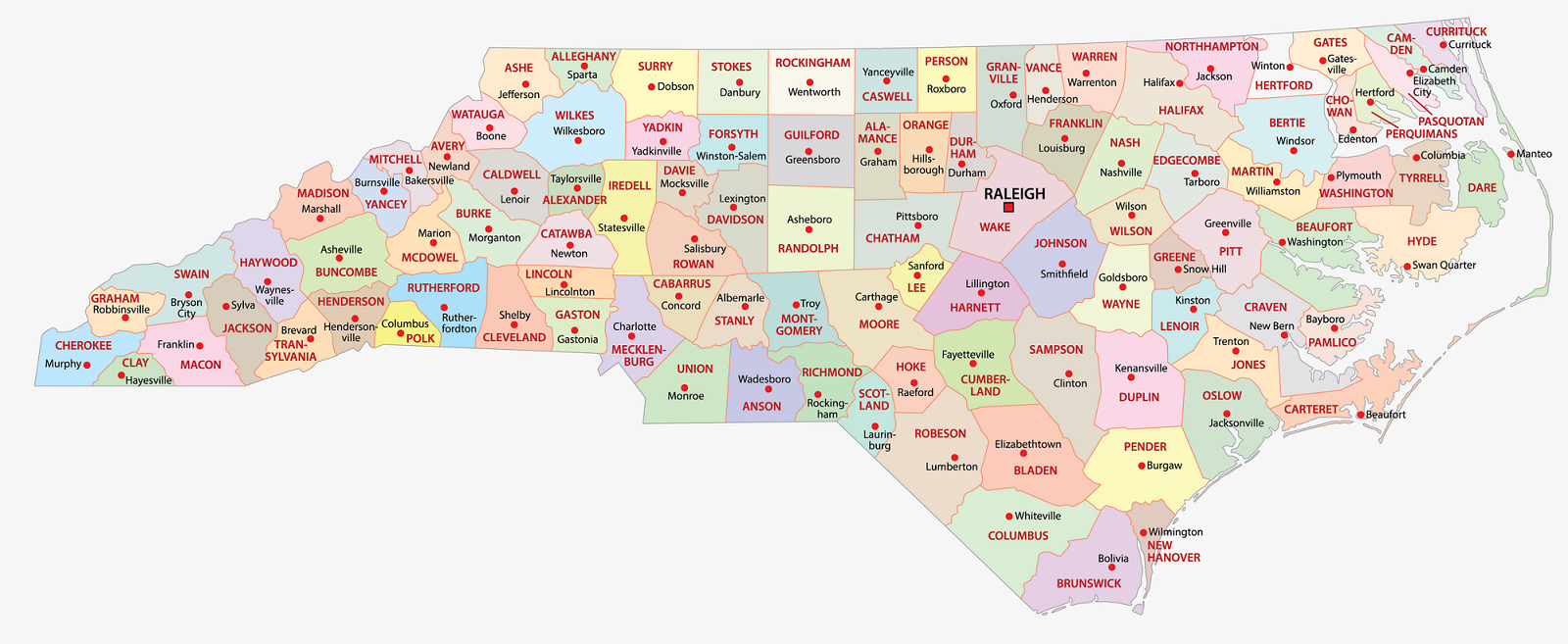
1. County Map of North Carolina:
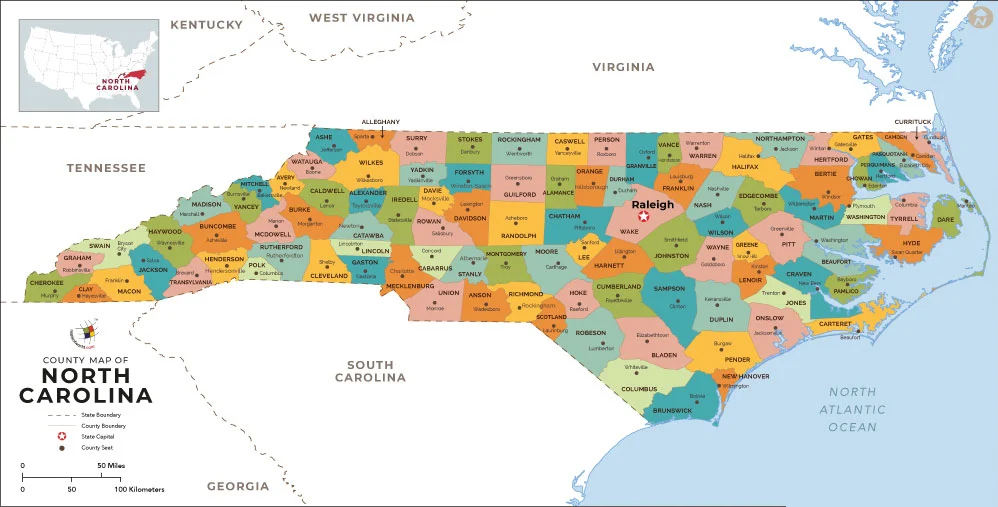
2. Map of North Carolina with Counties:
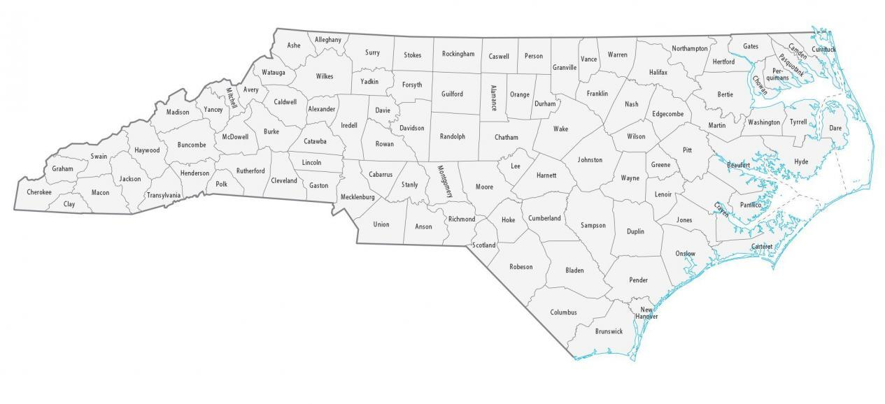
3. NC County Map:
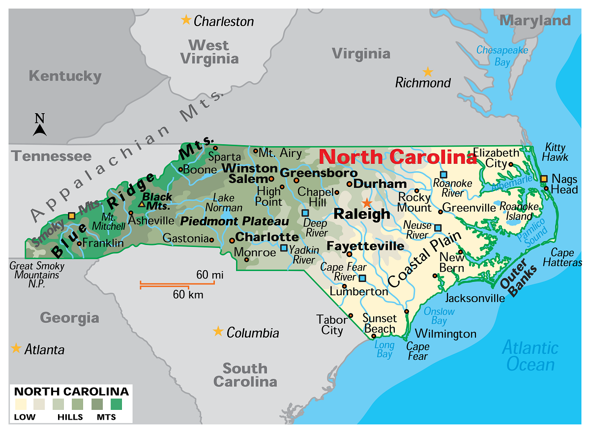
4. North Carolina Map:
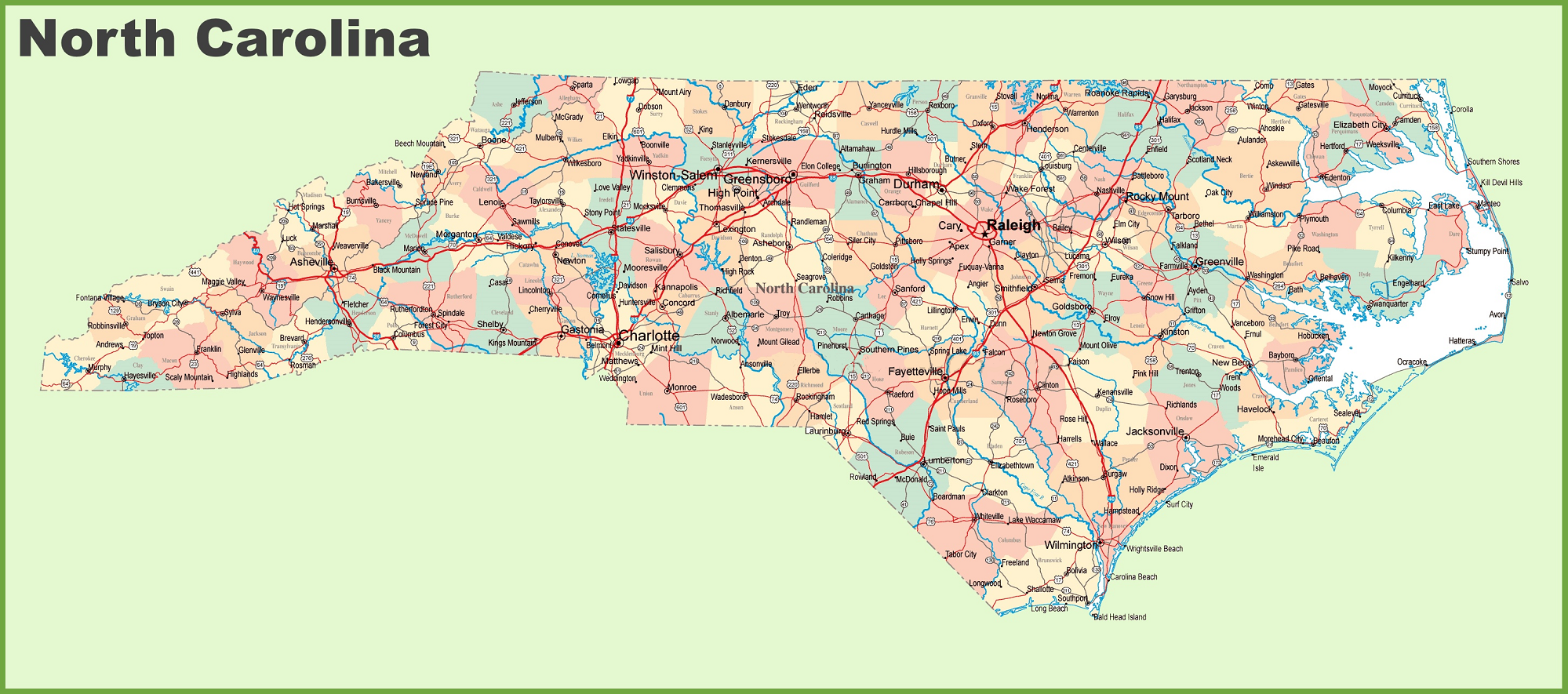
5. North Carolina Map with Cities and Towns:
This is the collection of some NC county map that we have added above. We have added a total of five different maps that contain some helpful information about the counties and cities. Here, we are adding some brief information about each map. So, please read the full description before downloading any map from the above collection.
The first map is the main county map of North Carolina, which shows only county names. And the next map is also a map of North Carolina counties but it is visually different. This is a blank and outlined county map of North Carolina state. Below we are also adding a table that shows some useful information about the counties of this state. Please check the table for useful and additional information.
Counties in North Carolina, USA:
This is a list of all counties of North Carolina with some useful information like the name of the county, the county seat, the year in which a county was formed, and the total area covered by these counties.
| County | County seat | Est. | Population | Area |
| Alexander County | Taylorsville | 1847 | 36644 | 263 sq mi |
| Alleghany County | Sparta | 1859 | 11049 | 236 sq mi |
| Anson County | Wadesboro | 1750 | 22060 | 537 sq mi |
| Ashe County | Jefferson | 1799 | 26711 | 427 sq mi |
| Avery County | Newland | 1911 | 17864 | 247 sq mi |
| Beaufort County | Washington | 1712 | 44468 | 959 sq mi |
| Bertie County | Windsor | 1722 | 17505 | 741 sq mi |
| Bladen County | Elizabethtown | 1734 | 29525 | 887 sq mi |
| Brunswick County | Bolivia | 1764 | 144215 | 860 sq mi |
| Buncombe County | Asheville | 1791 | 271534 | 660 sq mi |
| Burke County | Morganton | 1777 | 87611 | 515 sq mi |
| Cabarrus County | Concord | 1792 | 231278 | 365 sq mi |
| Caldwell County | Lenoir | 1841 | 80463 | 474 sq mi |
| Camden County | Camden | 1777 | 10835 | 306 sq mi |
| Carteret County | Beaufort | 1722 | 68541 | 1,341 sq mi |
| Caswell County | Yanceyville | 1777 | 22714 | 428 sq mi |
| Catawba County | Newton | 1842 | 161723 | 414 sq mi |
| Chatham County | Pittsboro | 1771 | 77889 | 709 sq mi |
| Cherokee County | Murphy | 1839 | 29167 | 497 sq mi |
| Chowan County | Edenton | 1668 | 13722 | 233 sq mi |
| Clay County | Hayesville | 1861 | 11309 | 221 sq mi |
| Cleveland County | Shelby | 1841 | 100359 | 469 sq mi |
| Columbus County | Whiteville | 1808 | 50092 | 954 sq mi |
| Craven County | New Bern | 1705 | 100674 | 774 sq mi |
| Cumberland County | Fayetteville | 1754 | 335508 | 658 sq mi |
| Currituck County | Currituck | 1668 | 29653 | 526 sq mi |
| Dare County | Manteo | 1870 | 37826 | 1,562 sq mi |
| Davidson County | Lexington | 1822 | 170637 | 567 sq mi |
| Davie County | Mocksville | 1836 | 43533 | 267 sq mi |
| Duplin County | Kenansville | 1750 | 48515 | 819 sq mi |
| Durham County | Durham | 1881 | 326126 | 298 sq mi |
| Edgecombe County | Tarboro | 1741 | 48359 | 507 sq mi |
| Forsyth County | Winston-Salem | 1849 | 385523 | 413 sq mi |
| Franklin County | Louisburg | 1779 | 71703 | 495 sq mi |
| Gaston County | Gastonia | 1846 | 230856 | 364 sq mi |
| Gates County | Gatesville | 1779 | 10366 | 346 sq mi |
| Graham County | Robbinsville | 1872 | 8043 | 302 sq mi |
| Granville County | Oxford | 1746 | 61986 | 537 sq mi |
| Greene County | Snow Hill | 1799 | 20417 | 266 sq mi |
| Guilford County | Greensboro | 1771 | 542410 | 658 sq mi |
| Halifax County | Halifax | 1758 | 48272 | 731 sq mi |
| Harnett County | Lillington | 1855 | 135966 | 601 sq mi |
| Haywood County | Waynesville | 1808 | 62476 | 555 sq mi |
| Henderson County | Hendersonville | 1838 | 116829 | 375 sq mi |
| Hertford County | Winton | 1759 | 21278 | 360 sq mi |
| Hoke County | Raeford | 1911 | 53114 | 392 sq mi |
| Hyde County | Swan Quarter | 1712 | 4508 | 1,424 sq mi |
| Iredell County | Statesville | 1788 | 191968 | 597 sq mi |
| Jackson County | Sylva | 1851 | 43410 | 494 sq mi |
| Johnston County | Smithfield | 1746 | 226504 | 796 sq mi |
| Jones County | Trenton | 1779 | 9255 | 473 sq mi |
| Lee County | Sanford | 1907 | 64138 | 259 sq mi |
| Lenoir County | Kinston | 1791 | 54706 | 402 sq mi |
| Lincoln County | Lincolnton | 1779 | 89670 | 307 sq mi |
| Macon County | Franklin | 1828 | 37564 | 519 sq mi |
| Madison County | Marshall | 1851 | 21502 | 452 sq mi |
| Martin County | Williamston | 1774 | 21754 | 461 sq mi |
| McDowell County | Marion | 1842 | 44717 | 446 sq mi |
| Mecklenburg County | Charlotte | 1762 | 1122276 | 546 sq mi |
| Mitchell County | Bakersville | 1861 | 14963 | 222 sq mi |
| Montgomery County | Troy | 1779 | 25798 | 502 sq mi |
| Moore County | Carthage | 1784 | 102763 | 706 sq mi |
| Nash County | Nashville | 1777 | 95176 | 543 sq mi |
| New Hanover County | Wilmington | 1729 | 229018 | 328 sq mi |
| Northampton County | Jackson | 1741 | 17129 | 551 sq mi |
| Onslow County | Jacksonville | 1734 | 206160 | 909 sq mi |
| Orange County | Hillsborough | 1752 | 148884 | 401 sq mi |
| Pamlico County | Bayboro | 1872 | 12344 | 566 sq mi |
| Pasquotank County | Elizabeth City | 1668 | 40821 | 289 sq mi |
| Pender County | Burgaw | 1875 | 62815 | 933 sq mi |
| Perquimans County | Hertford | 1668 | 13130 | 329 sq mi |
| Person County | Roxboro | 1791 | 39127 | 404 sq mi |
| Pitt County | Greenville | 1760 | 172169 | 655 sq mi |
| Polk County | Columbus | 1855 | 19656 | 239 sq mi |
| Randolph County | Asheboro | 1779 | 145172 | 790 sq mi |
| Richmond County | Rockingham | 1779 | 42724 | 480 sq mi |
| Robeson County | Lumberton | 1787 | 116328 | 951 sq mi |
| Rockingham County | Wentworth | 1785 | 91266 | 572 sq mi |
| Rowan County | Salisbury | 1753 | 148150 | 524 sq mi |
| Rutherford County | Rutherfordton | 1779 | 64586 | 566 sq mi |
| Sampson County | Clinton | 1784 | 58990 | 947 sq mi |
| Scotland County | Laurinburg | 1899 | 34227 | 321 sq mi |
| Stanly County | Albemarle | 1841 | 63425 | 404 sq mi |
| Stokes County | Danbury | 1789 | 44553 | 456 sq mi |
| Surry County | Dobson | 1771 | 71152 | 538 sq mi |
| Swain County | Bryson City | 1871 | 14136 | 541 sq mi |
| Transylvania County | Brevard | 1861 | 33165 | 381 sq mi |
| Tyrrell County | Columbia | 1729 | 3254 | 600 sq mi |
| Union County | Monroe | 1842 | 243648 | 640 sq mi |
| Vance County | Henderson | 1881 | 42185 | 270 sq mi |
| Wake County | Raleigh | 1771 | 1150204 | 857 sq mi |
| Warren County | Warrenton | 1779 | 18762 | 444 sq mi |
| Washington County | Plymouth | 1799 | 10892 | 424 sq mi |
| Watauga County | Boone | 1849 | 54234 | 313 sq mi |
| Wayne County | Goldsboro | 1779 | 116835 | 557 sq mi |
| Wilkes County | Wilkesboro | 1777 | 65806 | 760 sq mi |
| Wilson County | Wilson | 1855 | 78369 | 374 sq mi |
| Yadkin County | Yadkinville | 1850 | 37192 | 337 sq mi |
| Yancey County | Burnsville | 1833 | 18757 | 313 sq mi |
As we have briefly discussed about some counties in the introduction. Now, with the help of about mentioned table you can get more information about the population, county seats and area of counties. And, for more additional information you can check the maps that we have pinned in the upper section.
If you are looking for some other maps related to this state then you should check our other article.
- North Carolina (NC) Road and Highway Map (Free & Printable)
- North Carolina Map | State, Outline, County, Cities, Towns
And the fourth map is a detailed map of North Carolina. All major cities and towns are visible on this map with all major roads. And major lakes and rivers are also shown on this map. The fifth map is a cities and towns map of this state that shows all counties, major cities, city roads, and interstate highways. So, these were some printable maps that we have added above. These large maps are available in PDF and JPG (Image) formats. You can easily download any map by clicking on the buttons under the preview image. All these maps are free to download.