Indianapolis is the largest city located in the Indiana state of the US. Indianapolis is also known as “Indy”. It is a beautiful city that has everything like rivers, mountains or beautiful beaches. So, if you want to explore more about this city or planning to travel across the city, then you must have an “indy traffic map” or Indianapolis road map. So, here we have some amazing and detailed Indianapolis Road Maps and Highway Map. Let’s start with the Indianapolis Traffic map, then we have other detailed maps like Road, Highway, Walk, etc.
Indianapolis Road and Highway Map Collection:
1. Indianapolis Traffic Map:

2. Indianapolis Road Map:

3. Indianapolis Highway Map:

4. Large Detailed Map of Indianapolis:

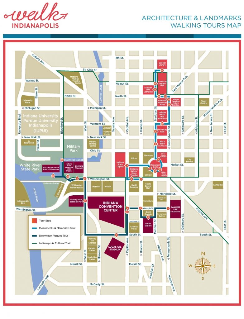
5. Indianapolis Walk Map:
6. Indianapolis Ride Map:

7. Indianapolis Tourist Attractions Map:

As you can see there are seven different types of maps that we have here. Each map contains some useful information.
The first map titled “Indianapolis Traffic Map” contains all the traffic and road information about the city. The red lines show the heavy traffic roads and the green line indicates the road with less traffic.
The second map titled “Indianapolis Road Map” contains all details of roads and their routes which are connecting other cities with Indianapolis. You can easily identify any direction and navigate anywhere inside the city.
The third map titled “Indianapolis Highway Maps” contains information about interstate highways, state routes, and US routes which are connecting with Indianapolis.
The fourth map is named “Large Detailed Map of Indianapolis”. In this map, you get a lot of information. This map contains all important places like Schools, Colleges, Hospitals, Parks, Zoos, Police Stations, Gas Stations, Restaurants, all roads, lakes, rivers, and streets roads.
The fifth map is titled “Indianapolis Walk Map”. It contains all the landmarks and walking routes of all famous cultural buildings like Church, Theatre, Embassy, Malls, Hotels, Parks, and Museums. You can easily walk around the city with the help of this map.
The sixth map named “Indianapolis Ride Map” shows all the landmarks and bicycle storage locations within the city. There are approx more than 250 bicycle storage locations across the city. Anyone can easily pick up or drop cycles to travel up to a small distance. This map will help you to know about all the bicycle riding routes of Indianapolis.
The seventh map titled “Indianapolis Tourist Attractions Map” will provide you the information about tourist places and their location as well as their routes. You can easily navigate to anywhere in the city with the help of this map. Important contact numbers of places are also listed on the map.
So, these were some important and useful road and highways maps that we have added above. All the maps are available in PDF format as well as in JPG (Image) format. You can easily download any map by clicking on the buttons under the preview image of a particular map.