Georgia is famous for its stunning landscape with majestic mountains and wondrous waterfalls. In the midst of all this, you will also get to see some amazing and beautiful lakes which are surrounded by natural beauty. Here we are adding some famous Georgia lakes maps. Please check all maps related to Georgia’s lakes and visit those beautiful lakes. Scroll down the page and have a look at the collections.
Georgia Lakes Map Collection:
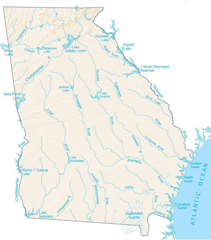
1. Georgia Lakes Map:
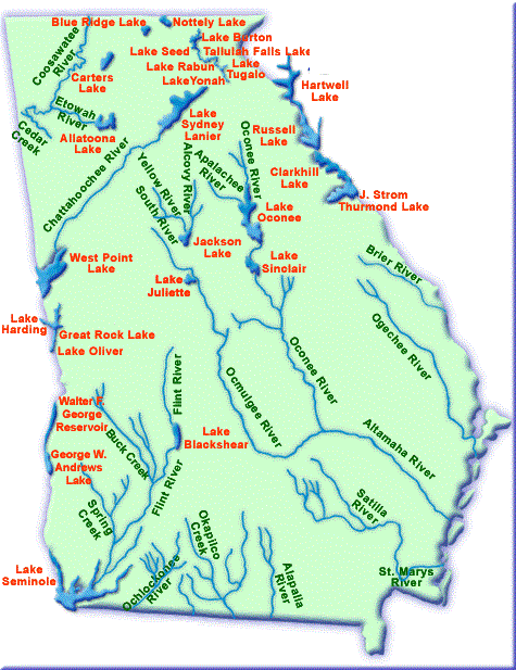
2. Map of Georgia Lake:
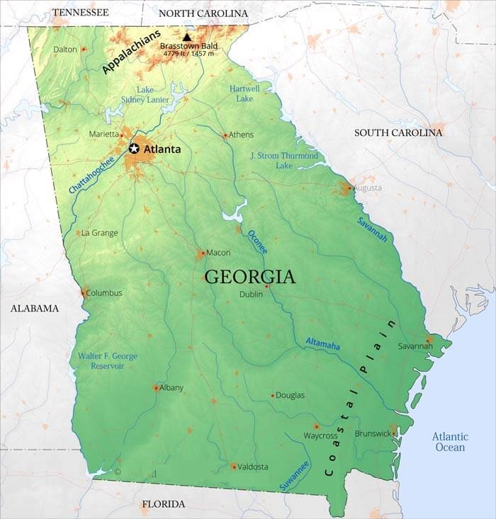
3. North Georgia Lakes Map:
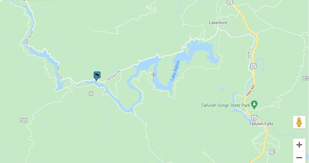
4. Lake Rabun Map:
These were some maps related to the lakes and rivers of Georgia that you have seen above. All of these maps have very detailed information about the lakes in Georgia. Below we have also included two tables that show the list of lakes that are in Georgia State. The first table shows the list of the largest lakes only. You can check the table for various information related to lakes such as total area, depth, height from above the sea level and the region where a lake is flowing. Please scroll down the page and check the tables.
Largest Lakes in Gerogia (GA), USA
| Lake | Surface Area (km2) | Maximum Depth (m) | Height above Sea Level (m) | Region |
| Paravani Lake | 37.5 | 3.3 | 2073 | Samtskhe-Javakheti |
| Kartsakhi Lake | 26.3 | 1 | 1799 | Samtskhe-Javakheti |
| Paliastomi Lake | 18.2 | 3.2 | -0.3 | Samegrelo-Zemo Svaneti |
| Tabatsquri Lake | 14.2 | 40.2 | 1997 | Samtskhe-Javakheti |
| Khanchali Lake | 13.3 | 0.7 | 1928 | Samtskhe-Javakheti |
| Jandari Lake | 10.6 | 7.2 | 291 | Kvemo Kartli |
| Madatapa Lake | 8.8 | 1.7 | 2108 | Samtskhe-Javakheti |
| Saghamo Lake | 4.8 | 2.3 | 1996 | Samtskhe-Javakheti |
| Ritsa Lake | 1.5 | 101 | 884 | Abkhazia |
| Keli Lake | 1.3 | 63 | 2914 | Mtskheta-Mtianeti |
| Bazaleti Lake | 1.2 | 7 | 878 | Mtskheta-Mtianeti |
List of all lakes that are in Georgia State of USA
In this table, you will get to know the names of all the smallest and largest lakes that are flowing through the Georgia State. Please check the whole table for more information.
- Lake Allatoona
- Lake Arrowhead
- Lake Blackshear
- Lake Blue Ridge
- Lake Burton
- Carters Lake
- Chatuge Lake (extends into North Carolina)
- Chief McIntosh Lake
- Coleman Pond
- Davenport Lake
- Gannet Lake
- Goat Rock Lake
- Lake Harding (extends into Alabama)
- Lake Hartwell (extends into South Carolina)
- Hard Labor Creek Regional Reservoir
- Houston Lake (Georgia)
- Lot Pond
- Lake Jackson
- Lake Jodeco
- Lake Lanier
- Lake Nottely
- Lake Oconee:)
- Old Hell Lake
- Lake Oliver
- Lake Peachtree
- Pilcher Pond
- Lake Rabun
- Lake Seminole (extends into Florida)
- Lake Sinclair
- Lake Spivey
- Lake Strom Thurmond (extends into South Carolina. Largest lake in Georgia)
- Tallulah Falls Lake
- Taylors Lake
- Lake Tugalo (extends into South Carolina)
- Walter F. George Lake (extends into Alabama)
- West Point Lake (extends into Alabama)
The first map shows all the rivers and lakes that are flowing through Georgia. This map has all the information so that you can easily locate any lakes. On this map, you can even see the origin and fall of rivers. Please check these maps to get more information in detail.
On the next map, you can see all the major lakes and rivers. This map shows lakes in dark red and rivers in blue, so you can easily identify the lakes and rivers. The third map shows the north GA (Georgia) lakes map. As you can see, north Hartwell Lake is the second largest lake which is extending to six counties in two states. You can get further information about this lake by seeing this map, so have a look at this map.
Above were some lakes and river maps of Georgia state. These maps are available in both PDF and JPG format. Save or Download any map by clicking on the buttons that are under the preview image of each map.