The State of Georgia is situated in the Southeastern region of the United States of America. Georgia is the 24th largest state in the USA and has 159 counties. Burke County becomes the first county on 5th February 1777. Based on the area, Ware county is the largest county and Clarke County is the smallest county in Georgia, USA.
If you want to explore more about the counties of Georgia state then you should scroll down the page because we have added a GA county map and some other printable maps along with some detailed information about each county. So, let’s start with these high-quality & interactive maps.
Printable Georgia (GA) County Maps Collection:
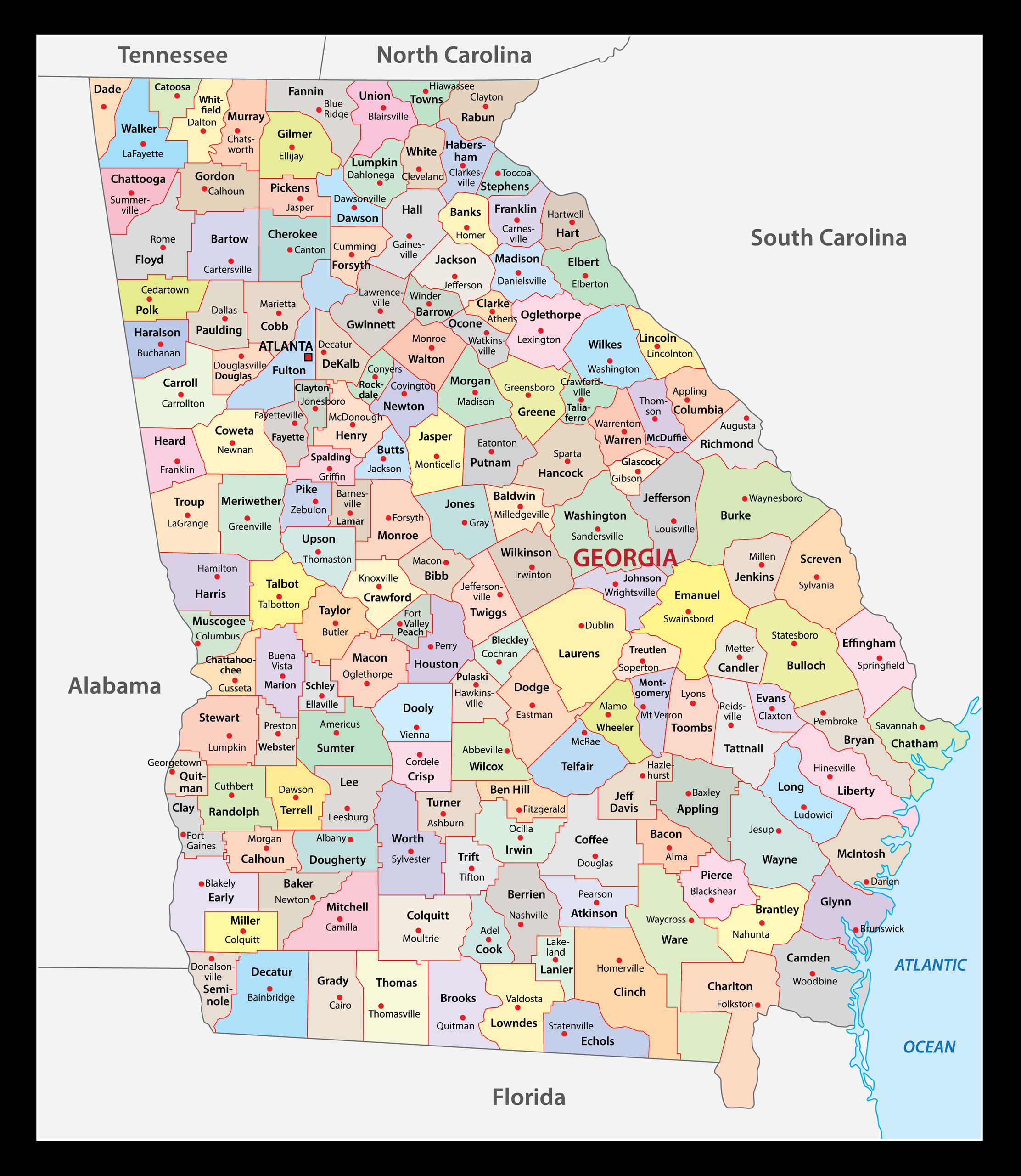
1. Georgia County Map:
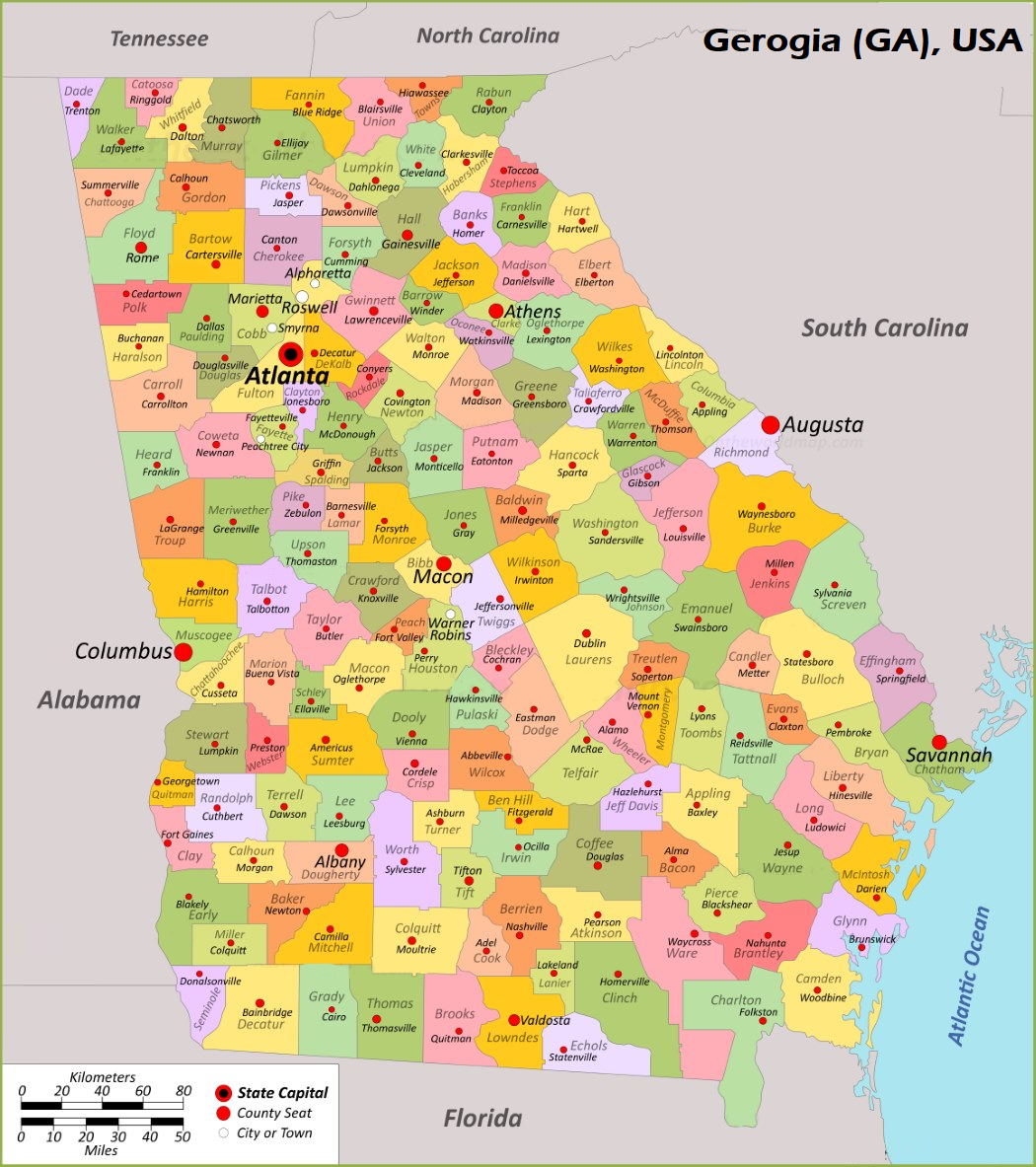
2. Map of Georgia with Counties:
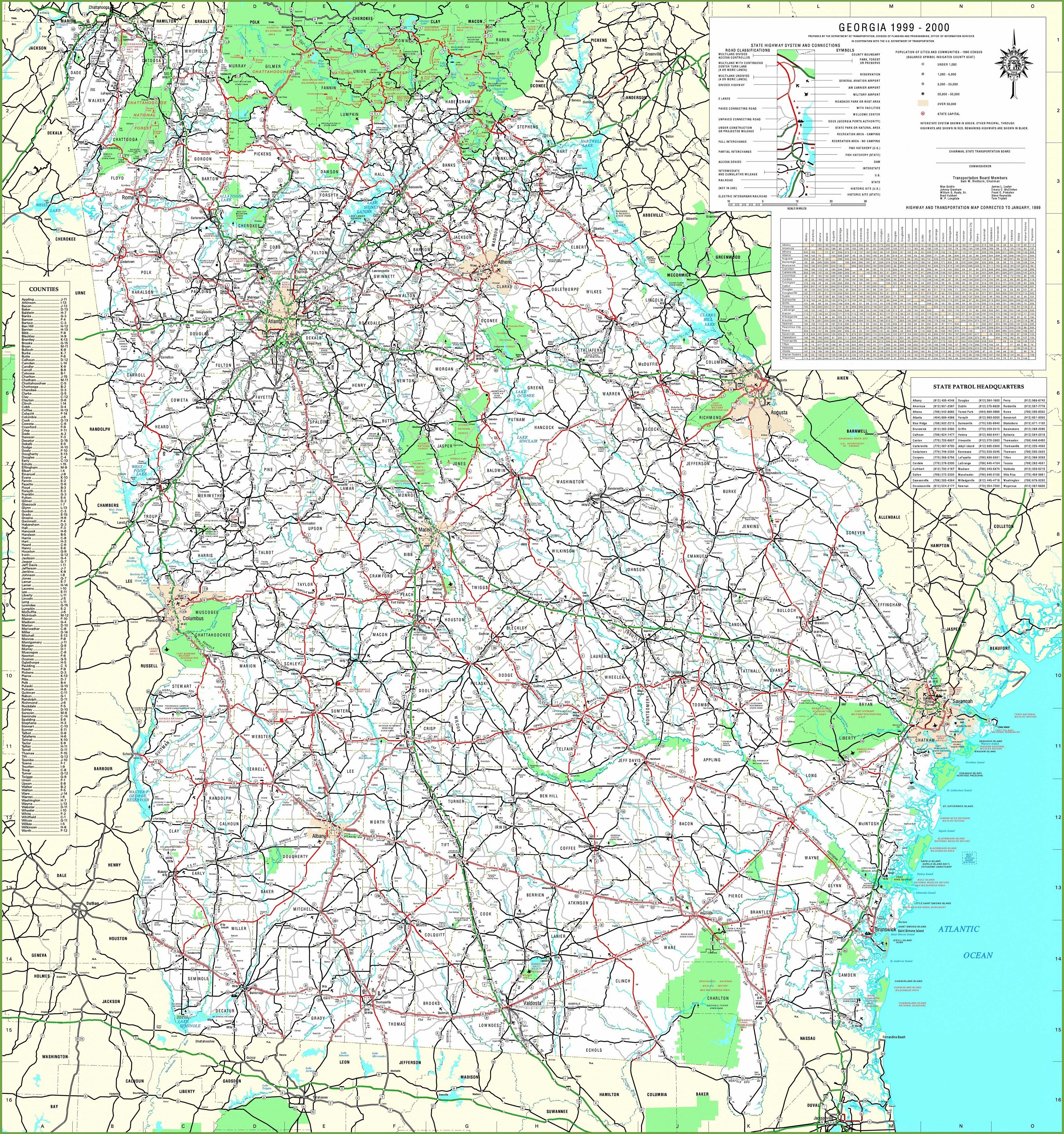
3. Georgia Map with Cities & Towns:
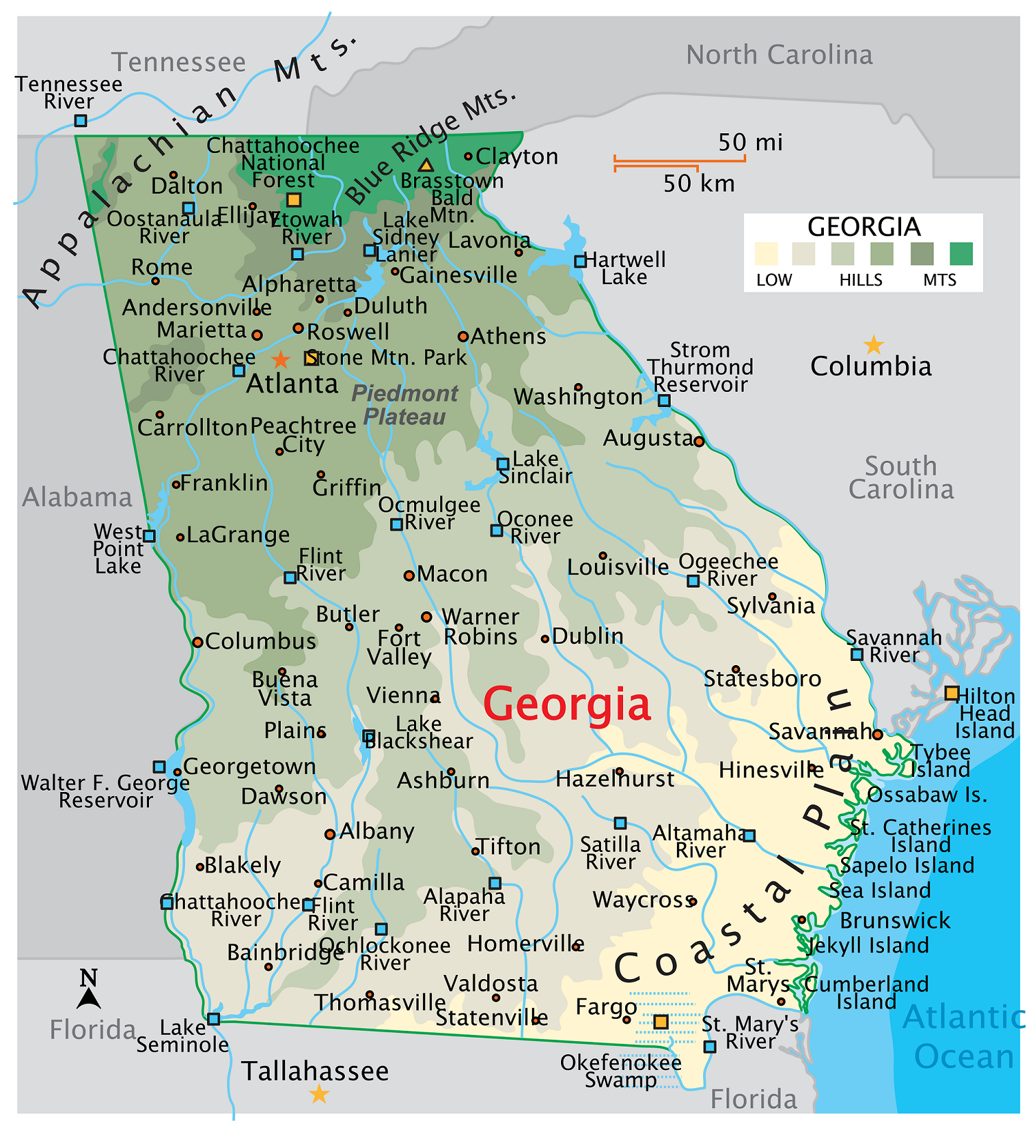
4. Map of Georgia:
We have added this collection of printable maps of Georgia County. We have added five different maps that contain useful information about all counties of this state. Below, we are adding some brief information about each map. So, please read the full description before viewing or saving any map on your device. We are also including a table that shows some useful information about GA counties. Please check the entire table.
If you are looking for some other maps related to the State of Georgia then you should check our other articles.
- Free Printable Georgia (GA) Lakes Map
- Free Printable Highway Maps of Georgia (GA)
- Free Road Maps of Georgia
- Free Georgia River Maps
- Free Georgia Mountain Maps
- Map of Georgia | State, Outline, County, Cities, Towns
List of all Counties in Georgia State
This is a list of all counties with some additional information like name of county name, year of establishment, populations, and total area.
| County | Established | Population | Area |
| Appling County | 1818 | 18488 | 509 sq mi |
| Atkinson County | 1917 | 8391 | 338 sq mi |
| Bacon County | 1914 | 11079 | 285 sq mi |
| Baker County | 1825 | 2819 | 343 sq mi |
| Baldwin County | 1803 | 43781 | 258 sq mi |
| Banks County | 1859 | 18562 | 234 sq mi |
| Barrow County | 1914 | 86658 | 162 sq mi |
| Bartow County | 1832 | 110843 | 460 sq mi |
| Ben Hill County | 1906 | 17158 | 252 sq mi |
| Berrien County | 1856 | 18147 | 452 sq mi |
| Bibb County | 1822 | 156762 | 250 sq mi |
| Bleckley County | 1912 | 12607 | 217 sq mi |
| Brantley County | 1920 | 18101 | 444 sq mi |
| Brooks County | 1858 | 16270 | 494 sq mi |
| Bryan County | 1793 | 46938 | 442 sq mi |
| Bulloch County | 1796 | 82442 | 683 sq mi |
| Burke County | 1777 | 24310 | 831 sq mi |
| Butts County | 1825 | 25781 | 187 sq mi |
| Calhoun County | 1854 | 5509 | 280 sq mi |
| Camden County | 1777 | 55664 | 630 sq mi |
| Candler County | 1914 | 11037 | 247 sq mi |
| Carroll County | 1826 | 121968 | 499 sq mi |
| Catoosa County | 1853 | 68397 | 162 sq mi |
| Charlton County | 1854 | 12766 | 781 sq mi |
| Chatham County | 1777 | 296329 | 440 sq mi |
| Chattahoochee County | 1854 | 9048 | 249 sq mi |
| Chattooga County | 1838 | 24932 | 314 sq mi |
| Cherokee County | 1831 | 274615 | 424 sq mi |
| Clarke County | 1801 | 128711 | 121 sq mi |
| Clay County | 1854 | 2882 | 195 sq mi |
| Clayton County | 1858 | 297100 | 143 sq mi |
| Clinch County | 1850 | 6725 | 809 sq mi |
| Cobb County | 1832 | 766802 | 340 sq mi |
| Coffee County | 1854 | 43386 | 599 sq mi |
| Colquitt County | 1856 | 45812 | 552 sq mi |
| Columbia County | 1790 | 159639 | 290 sq mi |
| Cook County | 1918 | 17225 | 229 sq mi |
| Coweta County | 1826 | 149956 | 443 sq mi |
| Crawford County | 1822 | 12153 | 325 sq mi |
| Crisp County | 1905 | 19879 | 274 sq mi |
| Dade County | 1837 | 16326 | 174 sq mi |
| Dawson County | 1857 | 28497 | 211 sq mi |
| Decatur County | 1823 | 29038 | 597 sq mi |
| DeKalb County | 1822 | 757718 | 268 sq mi |
| Dodge County | 1870 | 19759 | 501 sq mi |
| Dooly County | 1821 | 10885 | 393 sq mi |
| Dougherty County | 1853 | 84844 | 330 sq mi |
| Douglas County | 1870 | 145814 | 199 sq mi |
| Early County | 1818 | 10619 | 511 sq mi |
| Echols County | 1858 | 3699 | 404 sq mi |
| Effingham County | 1777 | 66741 | 480 sq mi |
| Elbert County | 1790 | 19579 | 369 sq mi |
| Emanuel County | 1812 | 22716 | 686 sq mi |
| Evans County | 1914 | 10672 | 185 sq mi |
| Fannin County | 1854 | 25817 | 386 sq mi |
| Fayette County | 1821 | 120574 | 197 sq mi |
| Floyd County | 1832 | 98771 | 513 sq mi |
| Forsyth County | 1832 | 260206 | 226 sq mi |
| Franklin County | 1784 | 23785 | 263 sq mi |
| Fulton County | 1853 | 1065334 | 529 sq mi |
| Gilmer County | 1832 | 32026 | 427 sq mi |
| Glascock County | 1857 | 2919 | 144 sq mi |
| Glynn County | 1777 | 84739 | 422 sq mi |
| Gordon County | 1850 | 58237 | 355 sq mi |
| Grady County | 1905 | 25918 | 458 sq mi |
| Greene County | 1786 | 19536 | 388 sq mi |
| Gwinnett County | 1818 | 964546 | 433 sq mi |
| Habersham County | 1818 | 46774 | 278 sq mi |
| Hall County | 1818 | 207369 | 394 sq mi |
| Hancock County | 1793 | 8630 | 473 sq mi |
| Haralson County | 1856 | 30572 | 282 sq mi |
| Harris County | 1827 | 35626 | 464 sq mi |
| Hart County | 1853 | 26409 | 232 sq mi |
| Heard County | 1830 | 11565 | 296 sq mi |
| Henry County | 1821 | 245235 | 323 sq mi |
| Houston County | 1821 | 166829 | 377 sq mi |
| Irwin County | 1818 | 9618 | 357 sq mi |
| Jackson County | 1796 | 80286 | 342 sq mi |
| Jasper County | 1807 | 15278 | 370 sq mi |
| Jeff Davis County | 1905 | 14872 | 333 sq mi |
| Jefferson County | 1796 | 15524 | 528 sq mi |
| Jenkins County | 1905 | 8639 | 350 sq mi |
| Johnson County | 1858 | 9160 | 304 sq mi |
| Jones County | 1807 | 28400 | 394 sq mi |
| Lamar County | 1920 | 19080 | 185 sq mi |
| Lanier County | 1920 | 9907 | 187 sq mi |
| Laurens County | 1807 | 49547 | 813 sq mi |
| Lee County | 1826 | 33411 | 356 sq mi |
| Liberty County | 1777 | 65711 | 519 sq mi |
| Lincoln County | 1796 | 7749 | 211 sq mi |
| Long County | 1920 | 17152 | 401 sq mi |
| Lowndes County | 1825 | 119276 | 504 sq mi |
| Lumpkin County | 1832 | 34278 | 284 sq mi |
| Macon County | 1837 | 12004 | 403 sq mi |
| Madison County | 1811 | 30885 | 284 sq mi |
| Marion County | 1827 | 7440 | 367 sq mi |
| McDuffie County | 1870 | 21633 | 260 sq mi |
| McIntosh County | 1793 | 11123 | 434 sq mi |
| Meriwether County | 1827 | 20793 | 503 sq mi |
| Miller County | 1856 | 5919 | 283 sq mi |
| Mitchell County | 1857 | 21521 | 512 sq mi |
| Monroe County | 1821 | 28712 | 396 sq mi |
| Montgomery County | 1793 | 8653 | 245 sq mi |
| Morgan County | 1807 | 20635 | 350 sq mi |
| Murray County | 1832 | 39951 | 344 sq mi |
| Muscogee County | 1826 | 205617 | 216 sq mi |
| Newton County | 1821 | 115355 | 276 sq mi |
| Oconee County | 1875 | 43023 | 186 sq mi |
| Oglethorpe County | 1793 | 15140 | 441 sq mi |
| Paulding County | 1832 | 173780 | 314 sq mi |
| Peach County | 1924 | 28417 | 151 sq mi |
| Pickens County | 1853 | 34024 | 232 sq mi |
| Pierce County | 1857 | 19976 | 343 sq mi |
| Pike County | 1822 | 19477 | 218 sq mi |
| Polk County | 1851 | 43496 | 311 sq mi |
| Pulaski County | 1808 | 9917 | 247 sq mi |
| Putnam County | 1807 | 22585 | 344 sq mi |
| Quitman County | 1858 | 2243 | 152 sq mi |
| Rabun County | 1819 | 17119 | 371 sq mi |
| Randolph County | 1828 | 6287 | 429 sq mi |
| Richmond County | 1777 | 205673 | 324 sq mi |
| Rockdale County | 1870 | 94082 | 131 sq mi |
| Schley County | 1857 | 4478 | 168 sq mi |
| Screven County | 1793 | 14105 | 648 sq mi |
| Seminole County | 1920 | 9197 | 238 sq mi |
| Spalding County | 1851 | 67909 | 198 sq mi |
| Stephens County | 1905 | 26865 | 179 sq mi |
| Stewart County | 1830 | 5341 | 459 sq mi |
| Sumter County | 1831 | 29283 | 485 sq mi |
| Talbot County | 1827 | 5742 | 393 sq mi |
| Taliaferro County | 1825 | 1558 | 195 sq mi |
| Tattnall County | 1801 | 23052 | 484 sq mi |
| Taylor County | 1852 | 7799 | 378 sq mi |
| Telfair County | 1807 | 12414 | 441 sq mi |
| Terrell County | 1856 | 8964 | 336 sq mi |
| Thomas County | 1825 | 45842 | 548 sq mi |
| Tift County | 1905 | 41212 | 265 sq mi |
| Toombs County | 1905 | 26911 | 367 sq mi |
| Towns County | 1856 | 12875 | 166 sq mi |
| Treutlen County | 1918 | 6306 | 201 sq mi |
| Troup County | 1826 | 69720 | 414 sq mi |
| Turner County | 1905 | 8966 | 286 sq mi |
| Twiggs County | 1809 | 7856 | 360 sq mi |
| Union County | 1832 | 25521 | 323 sq mi |
| Upson County | 1824 | 27720 | 326 sq mi |
| Walker County | 1833 | 68510 | 446 sq mi |
| Walton County | 1818 | 99853 | 329 sq mi |
| Ware County | 1824 | 36033 | 903 sq mi |
| Warren County | 1793 | 5240 | 286 sq mi |
| Washington County | 1784 | 19785 | 680 sq mi |
| Wayne County | 1803 | 30380 | 645 sq mi |
| Webster County | 1853 | 2367 | 210 sq mi |
| Wheeler County | 1912 | 7471 | 298 sq mi |
| White County | 1857 | 28442 | 242 sq mi |
| Whitfield County | 1851 | 102848 | 290 sq mi |
| Wilcox County | 1857 | 8739 | 380 sq mi |
| Wilkes County | 1777 | 9513 | 471 sq mi |
| Wilkinson County | 1803 | 8831 | 447 sq mi |
| Worth County | 1853 | 20554 | 570 sq mi |
The first map is the main county map of Georgia state, which shows all counties, county seats, or administrator cities of this state. The second map shows all counties with towns and cities. So, check this map if you are looking for a detailed county map of Georgia, USA
The third map is a map of Georgia with cities that shows all cities, roads, highways, rivers, and lakes. And the fourth map is a state map of Georgia. It is a full state map. And, if you are looking for a state map and city map of Georgia, you should click this link. So, these were some high-quality and printable maps that we have added above. These large HD maps are available in PDF and JPG (Image) formats. You can easily download any map by clicking on the buttons under the preview image. All these maps are free to download.