South Dakota is located in the North Central region of the country. It is seventeenth largest based on area and have 66 counties and these counties are divided in into approx. 300 cities, boroughs and towns. Meade County is the largest county that have an area of 8,990 km2 and have population of 30,173. And, in South Dakota, Aurora is the shortest county based on area which is 1,834 km2. You may explore more about the counties of South Dakota through its maps. Here on this page, we are adding some printable maps, now you must start with a South Dakota County Map and for this please scroll down the page and check our collection of maps.
South Dakota (SD) County Maps Collection:
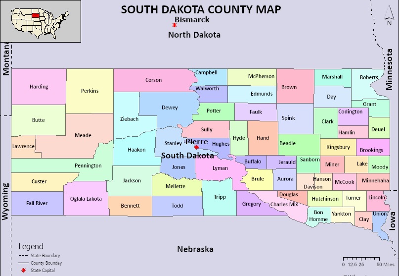
1. County Map of South Dakota:
2. Blank County Map of South Dakota:
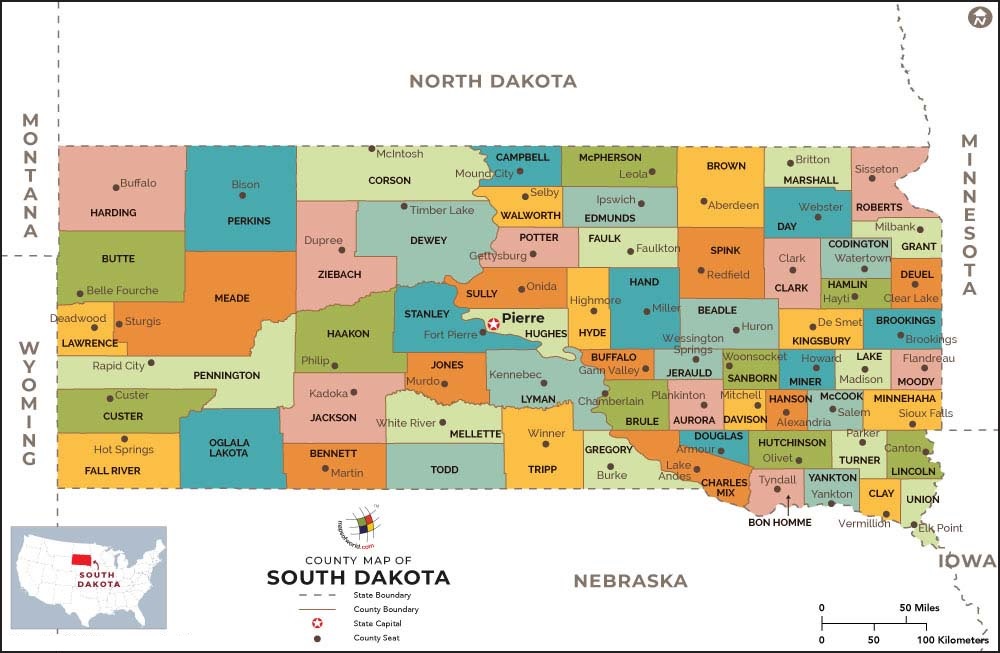
3. SD County Map
4. Printable County Map of South Dakota:
5. South Dakota Map with Cities:
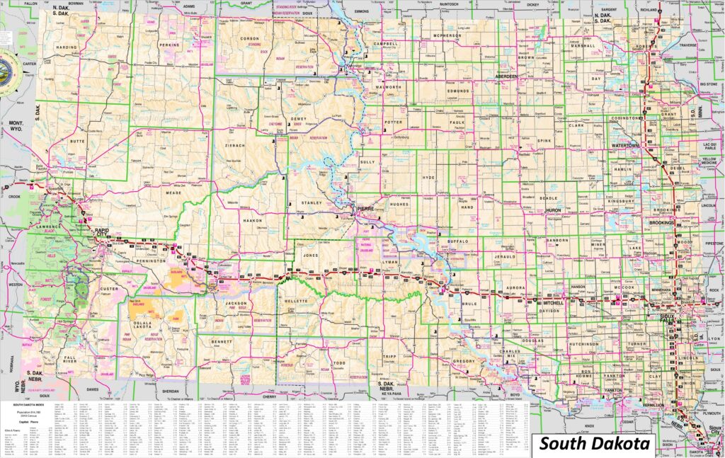
6. Map of South Dakota:
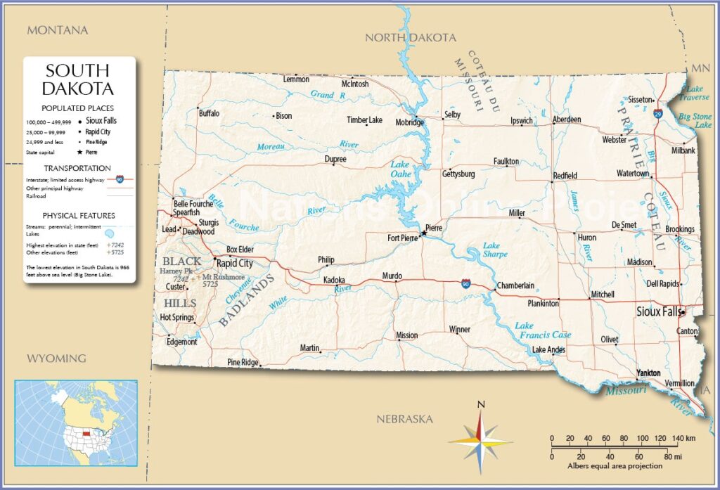
We have added above this collection of printable and high-quality maps of County. We have added a total of six different maps that contain helpful information about the counties and cities of South Dakota. Below, we are also adding some brief information about each map. So, please read the full description before viewing or saving any map in your device.
The first map is a simple coloured county map of South Dakota, which shows only county names. The second map is also a county map, but it differs from the above two maps. It is a simple and blank outline map.And the next map is a detailed SD county map with cities. So, check this map if you are looking for a full detailed county map of this state. Below we are also adding a list that shows some useful information about the counties of this state. Please read the entire table.
List of all Counties in South Dakota
This is a list of all counties of South Dakota with some helpful and additional information like the name of the county name, year of establishment in, populations, the county seat, and total area.
| S.N | County | County seat | Formed | Population | Area |
| 1 | Aurora County | Plankinton | 1881 | 2747 | 708 sq (1,834 km2) |
| 2 | Beadle County | Huron | 1879 | 19149 | 1,259 sq (3,261 km2) |
| 3 | Bennett County | Martin | 1909 | 3381 | 1,185 sq (3,069 km2) |
| 4 | Bon Homme County | Tyndall | 1862 | 7003 | 563 sq (1,458 km2) |
| 5 | Brookings County | Brookings | 1862 | 34375 | 794 sq (2,056 km2) |
| 6 | Brown County | Aberdeen | 1879 | 38301 | 1,713 sq (4,437 km2) |
| 7 | Brule County | Chamberlain | 1875 | 5247 | 819 sq (2,121 km2) |
| 8 | Buffalo County | Gann Valley | 1873 | 1948 | 471 sq (1,220 km2) |
| 9 | Butte County | Belle Fourche | 1883 | 10243 | 2,249 sq (5,825 km2) |
| 10 | Campbell County | Mound City | 1873 | 1377 | 736 sq (1,906 km2) |
| 11 | Charles Mix County | Lake Andes | 1862 | 9373 | 1,098 sq (2,844 km2) |
| 12 | Clark County | Clark | 1873 | 3837 | 958 sq (2,481 km2) |
| 13 | Clay County | Vermillion | 1862 | 14967 | 412 sq (1,067 km2) |
| 14 | Codington County | Watertown | 1877 | 28325 | 688 sq (1,782 km2) |
| 15 | Corson County | McIntosh | 1909 | 3902 | 2,473 sq (6,405 km2) |
| 16 | Custer County | Custer | 1875 | 8318 | 1,558 sq (4,035 km2) |
| 17 | Davison County | Mitchell | 1873 | 19956 | 436 sq (1,129 km2) |
| 18 | Day County | Webster | 1879 | 5449 | 1,029 sq (2,665 km2) |
| 19 | Deuel County | Clear Lake | 1862 | 4295 | 624 sq (1,616 km2) |
| 20 | Dewey County | Timber Lake | 1873 | 5239 | 2,303 sq (5,965 km2) |
| 21 | Douglas County | Armour | 1873 | 2835 | 434 sq (1,124 km2) |
| 22 | Edmunds County | Ipswich | 1873 | 3986 | 1,146 sq (2,968 km2) |
| 23 | Fall River County | Hot Springs | 1883 | 6973 | 1,740 sq (4,507 km2) |
| 24 | Faulk County | Faulkton | 1873 | 2125 | 1,000 sq (2,590 km2) |
| 25 | Grant County | Milbank | 1873 | 7556 | 682 sq (1,766 km2) |
| 26 | Gregory County | Burke | 1862 | 3994 | 1,016 sq (2,631 km2) |
| 27 | Haakon County | Philip | 1914 | 1872 | 1,813 sq (4,696 km2) |
| 28 | Hamlin County | Hayti | 1873 | 6164 | 511 sq (1,323 km2) |
| 29 | Hand County | Miller | 1873 | 3145 | 1,437 sq (3,722 km2) |
| 30 | Hanson County | Alexandria | 1873 | 3461 | 435 sq (1,127 km2) |
| 31 | Harding County | Buffalo | 1909 | 1311 | 2,671 sq (6,918 km2) |
| 32 | Hughes County | Pierre | 1880 | 17765 | 741 sq (1,919 km2) |
| 33 | Hutchinson County | Olivet | 1862 | 7427 | 813 sq (2,106 km2) |
| 34 | Hyde County | Highmore | 1873 | 1262 | 861 sq (2,230 km2) |
| 35 | Jackson County | Kadoka | 1914 | 2806 | 1,869 sq (4,841 km2) |
| 36 | Jerauld County | Wessington Springs | 1883 | 1663 | 530 sq (1,373 km2) |
| 37 | Jones County | Murdo | 1916 | 917 | 971 sq (2,515 km2) |
| 38 | Kingsbury County | De Smet | 1873 | 5187 | 838 sq (2,170 km2) |
| 39 | Lake County | Madison | 1873 | 11059 | 563 sq (1,458 km2) |
| 40 | Lawrence County | Deadwood | 1875 | 25768 | 800 sq (2,072 km2) |
| 41 | Lincoln County | Canton | 1867 | 65161 | 578 sq (1,497 km2) |
| 42 | Lyman County | Kennebec | 1873 | 3718 | 1,640 sq (4,248 km2) |
| 43 | Marshall County | Britton | 1885 | 4306 | 839 sq (2,173 km2) |
| 44 | McCook County | Salem | 1873 | 5682 | 575 sq (1,489 km2) |
| 45 | McPherson County | Leola | 1873 | 2411 | 1,137 sq (2,945 km2) |
| 46 | Meade County | Sturgis | 1889 | 29852 | 3,471 sq (8,990 km2) |
| 47 | Mellette County | White River | 1909 | 1918 | 1,307 sq (3,385 km2) |
| 48 | Miner County | Howard | 1873 | 2298 | 570 sq (1,476 km2) |
| 49 | Minnehaha County | Sioux Falls | 1862 | 197214 | 809 sq (2,095 km2) |
| 50 | Moody County | Flandreau | 1873 | 6336 | 520 sq (1,347 km2) |
| 51 | Oglala Lakota County | 1875 | 13672 | 2,094 sq (5,423 km2) | |
| 52 | Pennington County | Rapid City | 1875 | 109222 | 2,776 sq (7,190 km2) |
| 53 | Perkins County | Bison | 1909 | 2835 | 2,872 sq (7,438 km2) |
| 54 | Potter County | Gettysburg | 1875 | 2472 | 866 sq (2,243 km2) |
| 55 | Roberts County | Sisseton | 1883 | 10280 | 1,101 sq (2,852 km2) |
| 56 | Sanborn County | Woonsocket | 1883 | 2330 | 569 sq (1,474 km2) |
| 57 | Spink County | Redfield | 1873 | 6361 | 1,504 sq (3,895 km2) |
| 58 | Stanley County | Fort Pierre | 1873 | 2980 | 1,443 sq (3,737 km2) |
| 59 | Sully County | Onida | 1873 | 1446 | 1,007 sq (2,608 km2) |
| 60 | Todd County | 1909 | 9319 | 1,388 sq (3,595 km2) | |
| 61 | Tripp County | Winner | 1873 | 5624 | 1,614 sq (4,180 km2) |
| 62 | Turner County | Parker | 1871 | 8673 | 617 sq (1,598 km2) |
| 63 | Union County | Elk Point | 1862 | 16811 | 460 sq (1,191 km2) |
| 64 | Walworth County | Selby | 1873 | 5315 | 708 sq (1,834 km2) |
| 65 | Yankton County | Yankton | 1862 | 23310 | 522 sq (1,352 km2) |
| 66 | Ziebach County | Dupree | 1911 | 2413 | 1,962 sq (5,082 km2) |
And the fifth map is a detailed city and town map of South Dakota state. All major cities and towns are visible on this map, with all street roads, national highways, all lakes, rivers are also shown on this map. And , the last map is a state map of SD, USA that shows some major cities and other important places. So, these were some high-quality and printable maps that we have added above. These large HD maps are available in PDF and JPG (Image) formats. You can easily download any map by clicking on the buttons under the preview image. All these maps are free to download.