Nebraska is located in the Midwestern region of the United States of America. It has 93 counties divided into various cities and towns. Cherry county is the largest whereas Sarpy County is the smallest in Nebraska county based on the area. And, if you are here to explore more about the counties and cities of NE, USA then you must check our page because here we are providing some printable maps related to counties of Nebraska that will help you a lot to learn about counties. So, please scroll down the page, and let’s start with a county map of Nebraska. You may also check some other maps related to the state and cities of Nebraska.
Nebraska (NE) County Maps Collection:
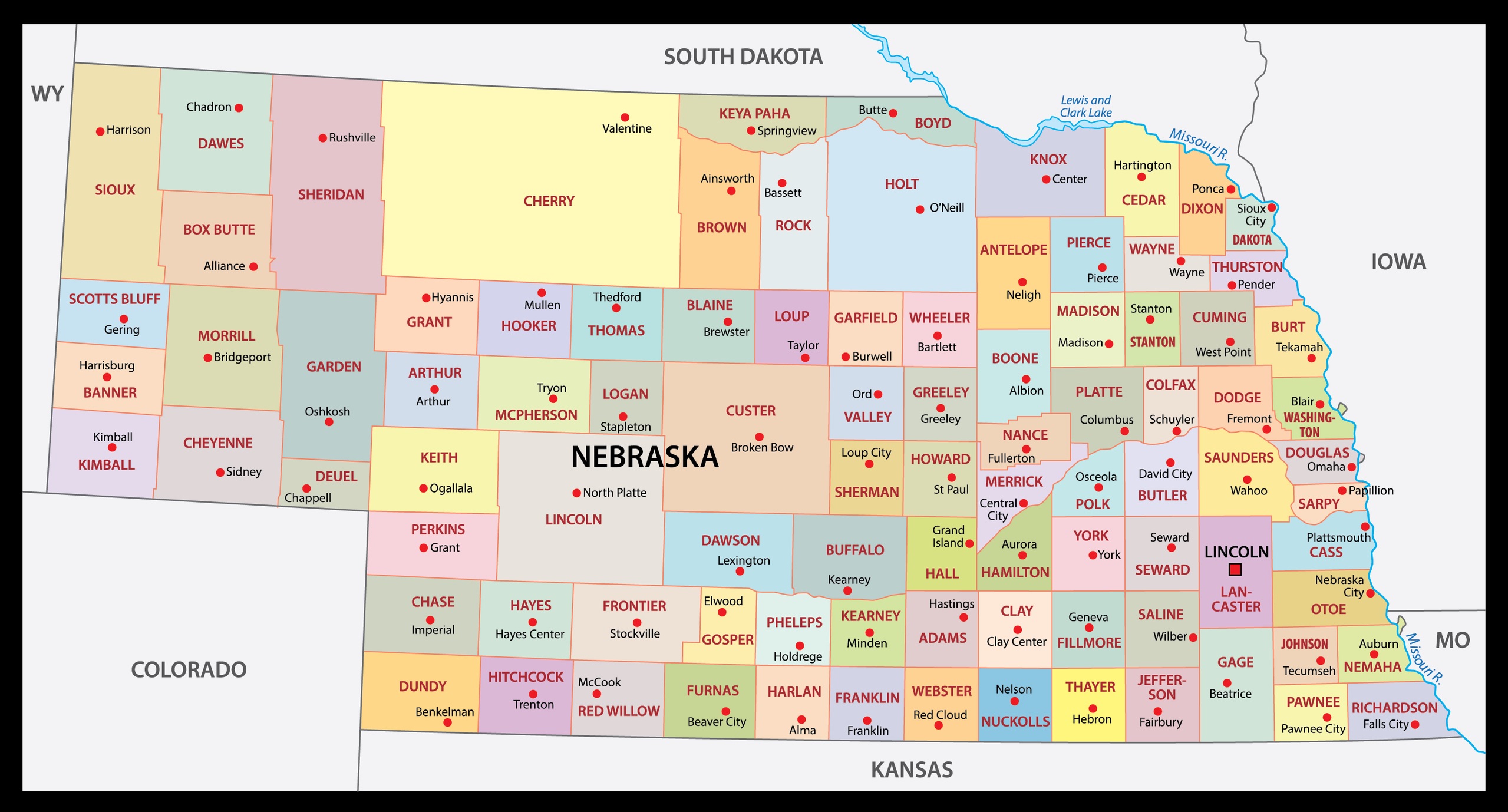
1. Map of Nebraska with Counties:
2. County Map of Nebraska:
3. Map of Nebraska with Cities and Towns:

4. Nebraska Map:

This is the collection of some high-quality NE county map that we have added above. We have added a total of four different maps that contain some helpful information about the counties and cities of Nebraska state. Here, we are adding some brief information about each map. So, please read the full description before downloading any map from the above collection.
The first map is a detailed county map of Nebraska, which shows county names along with cities, towns, and all county seats. The second map is also a blank or outlined county map of Nebraska. Below we are also adding a table that shows some useful information about the counties of Nebraska. Please read the entire table for additional information.
Counties in Nebraska, USA:
This is a list of all counties of this state with some useful information like the name of the county, the county seat, year of establishment, and total area.
| S.N | County | County Seat | Population | Area | Formed |
| 1 | Adams County | Hastings | 31610 | 563 sq mi | 1867 |
| 2 | Antelope County | Neligh | 6456 | 857 sq mi | 1871 |
| 3 | Arthur County | Arthur | 458 | 715 sq mi | 1887 |
| 4 | Banner County | Harrisburg | 759 | 746 sq mi | 1888 |
| 5 | Blaine County | Brewster | 482 | 711 sq mi | 1885 |
| 6 | Boone County | Albion | 5388 | 687 sq mi | 1871 |
| 7 | Box Butte County | Alliance | 11305 | 1,075 sq mi | 1887 |
| 8 | Boyd County | Butte | 2032 | 540 sq mi | 1891 |
| 9 | Brown County | Ainsworth | 2926 | 1,221 sq mi | 1883 |
| 10 | Buffalo County | Kearney | 47893 | 968 sq mi | 1855 |
| 11 | Burt County | Tekamah | 6574 | 493 sq mi | 1854 |
| 12 | Butler County | David City | 8312 | 584 sq mi | 1856 |
| 13 | Cass County | Plattsmouth | 25357 | 559 sq mi | 1854 |
| 14 | Cedar County | Hartington | 8711 | 740 sq mi | 1857 |
| 15 | Chase County | Imperial | 4000 | 894 sq mi | 1873 |
| 16 | Cherry County | Valentine | 5788 | 5,961 sq mi | 1883 |
| 17 | Cheyenne County | Sidney | 10091 | 1,196 sq mi | 1867 |
| 18 | Clay County | Clay Center | 6392 | 573 sq mi | 1855 |
| 19 | Colfax County | Schuyler | 10425 | 413 sq mi | 1869 |
| 20 | Cuming County | West Point | 8996 | 572 sq mi | 1855 |
| 21 | Custer County | Broken Bow | 10792 | 2,576 sq mi | 1877 |
| 22 | Dakota County | Dakota City | 20947 | 264 sq mi | 1855 |
| 23 | Dawes County | Chadron | 9088 | 1,396 sq mi | 1885 |
| 24 | Dawson County | Lexington | 24207 | 1,013 sq mi | 1860 |
| 25 | Deuel County | Chappell | 1937 | 440 sq mi | 1888 |
| 26 | Dixon County | Ponca | 5851 | 476 sq mi | 1856 |
| 27 | Dodge County | Fremont | 36515 | 534 sq mi | 1854 |
| 28 | Douglas County | Omaha | 537256 | 331 sq mi | 1854 |
| 29 | Dundy County | Benkelman | 1981 | 920 sq mi | 1873 |
| 30 | Fillmore County | Geneva | 5698 | 576 sq mi | 1856 |
| 31 | Franklin County | Franklin | 3085 | 576 sq mi | 1867 |
| 32 | Frontier County | Stockville | 2709 | 975 sq mi | 1872 |
| 33 | Furnas County | Beaver City | 4865 | 718 sq mi | 1873 |
| 34 | Gage County | Beatrice | 21864 | 855 sq mi | 1855 |
| 35 | Garden County | Oshkosh | 1902 | 1,705 sq mi | 1910 |
| 36 | Garfield County | Burwell | 2035 | 570 sq mi | 1884 |
| 37 | Gosper County | Elwood | 1972 | 458 sq mi | 1873 |
| 38 | Grant County | Hyannis | 633 | 776 sq mi | 1887 |
| 39 | Greeley County | Greeley | 2494 | 570 sq mi | 1871 |
| 40 | Hall County | Grand Island | 60720 | 546 sq mi | 1858 |
| 41 | Hamilton County | Aurora | 9112 | 544 sq mi | 1867 |
| 42 | Harlan County | Alma | 3513 | 553 sq mi | 1871 |
| 43 | Hayes County | Hayes Center | 976 | 713 sq mi | 1877 |
| 44 | Hitchcock County | Trenton | 2872 | 710 sq mi | 1873 |
| 45 | Holt County | O’Neill | 10449 | 2,413 sq mi | 1860 |
| 46 | Hooker County | Mullen | 738 | 721 sq mi | 1889 |
| 47 | Howard County | Saint Paul | 6355 | 570 sq mi | 1871 |
| 48 | Jefferson County | Fairbury | 7560 | 573 sq mi | 1856 |
| 49 | Johnson County | Tecumseh | 5144 | 376 sq mi | 1857 |
| 50 | Kearney County | Minden | 6548 | 516 sq mi | 1860 |
| 51 | Keith County | Ogallala | 8130 | 1,061 sq mi | 1873 |
| 52 | Keya Paha County | Springview | 790 | 773 sq mi | 1884 |
| 53 | Kimball County | Kimball | 3702 | 952 sq mi | 1888 |
| 54 | Knox County | Center | 8565 | 1,108 sq mi | 1857 |
| 55 | Lancaster County | Lincoln | 297036 | 839 sq mi | 1855 |
| 56 | Lincoln County | North Platte | 36051 | 2,564 sq mi | 1860 |
| 57 | Logan County | Stapleton | 763 | 571 sq mi | 1885 |
| 58 | Loup County | Taylor | 576 | 570 sq mi | 1883 |
| 59 | Madison County | Madison | 35278 | 573 sq mi | 1856 |
| 60 | McPherson County | Tryon | 526 | 859 sq mi | 1887 |
| 61 | Merrick County | Central City | 7802 | 485 sq mi | 1858 |
| 62 | Morrill County | Bridgeport | 4908 | 1,424 sq mi | 1908 |
| 63 | Nance County | Fullerton | 3623 | 441 sq mi | 1879 |
| 64 | Nemaha County | Auburn | 7157 | 409 sq mi | 1854 |
| 65 | Nuckolls County | Nelson | 4413 | 575 sq mi | 1860 |
| 66 | Otoe County | Nebraska City | 15752 | 616 sq mi | 1854 |
| 67 | Pawnee County | Pawnee City | 2709 | 432 sq mi | 1855 |
| 68 | Perkins County | Grant | 2921 | 883 sq mi | 1887 |
| 69 | Phelps County | Holdrege | 9213 | 540 sq mi | 1873 |
| 70 | Pierce County | Pierce | 7510 | 574 sq mi | 1856 |
| 71 | Platte County | Columbus | 32505 | 678 sq mi | 1856 |
| 72 | Polk County | Osceola | 5275 | 439 sq mi | 1856 |
| 73 | Red Willow County | McCook | 11006 | 717 sq mi | 1873 |
| 74 | Richardson County | Falls City | 8125 | 554 sq mi | 1854 |
| 75 | Rock County | Bassett | 1411 | 1,008 sq mi | 1885 |
| 76 | Saline County | Wilber | 14416 | 575 sq mi | 1867 |
| 77 | Sarpy County | Papillion | 169331 | 241 sq mi | 1857 |
| 78 | Saunders County | Wahoo | 20929 | 754 sq mi | 1856 |
| 79 | Scotts Bluff County | Gering | 36848 | 739 sq mi | 1888 |
| 80 | Seward County | Seward | 17089 | 575 sq mi | 1855 |
| 81 | Sheridan County | Rushville | 5251 | 2,441 sq mi | 1885 |
| 82 | Sherman County | Loup City | 3106 | 566 sq mi | 1871 |
| 83 | Sioux County | Harrison | 1475 | 1,313 sq mi | 1877 |
| 84 | Stanton County | Stanton | 6133 | 430 sq mi | 1855 |
| 85 | Thayer County | Hebron | 5189 | 575 sq mi | 1871 |
| 86 | Thomas County | Thedford | 699 | 713 sq mi | 1887 |
| 87 | Thurston County | Pender | 6895 | 394 sq mi | 1889 |
| 88 | Valley County | Ord | 4193 | 568 sq mi | 1871 |
| 89 | Washington County | Blair | 20223 | 390 sq mi | 1854 |
| 90 | Wayne County | Wayne | 9411 | 444 sq mi | 1867 |
| 91 | Webster County | Red Cloud | 3688 | 575 sq mi | 1867 |
| 92 | Wheeler County | Bartlett | 759 | 575 sq mi | 1877 |
| 93 | York County | York | 13883 | 576 sq mi | 1855 |
And the third map is a detailed map of this state. All major cities and towns are visible on this map with all major roads. And some water bodies are also shown on this map. The fourth map is a main map of Nebraska with cities that shows all counties, major cities, city roads, and interstate highways. So, these were some printable maps that we have added above. These large maps are available in PDF format and JPG (Image) format. You can easily download any map by clicking on the buttons under the preview image. All these H.D. maps are free to download.